Bulgaria, officially the Republic of Bulgaria, is a country in Southeast Europe. Located west of the Black Sea and south of the Danube river, Bulgaria is bordered by Greece and Turkey to the south, Serbia and North Macedonia to the west, and Romania to the north. It covers a territory of 110,994 square kilometres (42,855 sq mi) and is the 16th largest country in Europe. Sofia is the nation's capital and largest city; other major cities include Burgas, Plovdiv, and Varna.
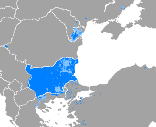
Bulgarian is an Eastern South Slavic language spoken in Southeast Europe, primarily in Bulgaria. It is the language of the Bulgarians.

The Balkan Wars were a series of two conflicts that took place in the Balkan states in 1912 and 1913. In the First Balkan War, the four Balkan states of Greece, Serbia, Montenegro and Bulgaria declared war upon the Ottoman Empire and defeated it, in the process stripping the Ottomans of their European provinces, leaving only Eastern Thrace under Ottoman control. In the Second Balkan War, Bulgaria fought against the other four original combatants of the first war. It also faced an attack from Romania from the north. The Ottoman Empire lost the bulk of its territory in Europe. Although not involved as a combatant, Austria-Hungary became relatively weaker as a much enlarged Serbia pushed for union of the South Slavic peoples. The war set the stage for the July crisis of 1914 and thus served as a prelude to the First World War.

The Balkans, corresponding partially with the Balkan Peninsula, is a geographical area in southeastern Europe with various geographical and historical definitions. The region takes its name from the Balkan Mountains that stretch throughout the whole of Bulgaria. The Balkan Peninsula is bordered by the Adriatic Sea in the northwest, the Ionian Sea in the southwest, the Aegean Sea in the south, the Turkish straits in the east, and the Black Sea in the northeast. The northern border of the peninsula is variously defined. The highest point of the Balkans is Musala, 2,925 metres (9,596 ft), in the Rila mountain range, Bulgaria.

Sofia is the capital and largest city of Bulgaria. It is situated in the Sofia Valley at the foot of the Vitosha mountain, in the western part of the country. The city is built west of the Iskar river and has many mineral springs, such as the Sofia Central Mineral Baths. It has a humid continental climate. Being in the centre of the Balkans, it is midway between the Black Sea and the Adriatic Sea and closest to the Aegean Sea.

Bulgarians are a nation and South Slavic ethnic group native to Bulgaria and its neighbouring region, who share a common Bulgarian ancestry, culture, history and language. They form the majority of the population in Bulgaria, while in North Macedonia, Ukraine, Moldova, Serbia, Albania, Romania, Hungary and Greece they exist as historical communities.

The Bulgaria national football team represents Bulgaria in men's international football, and is administered by the Bulgarian Football Union, a member association of UEFA.

The Iskar is a right tributary of the Danube. With a length of 368 km, it is the longest river that runs entirely within Bulgaria. Originating as three forks in Balkan's highest mountain range Rila, the Iskar flows in a northern direction until its confluence with the Danube. As it flows northwards it fuels the largest artificial lake in the country, the Iskar Reservoir, forms the divide between the Vitosha and Plana Mountains in the west and the Sredna Gora mountain range in the east before entering the Sofia Valley, which contains the nation's capital Sofia. From there the Iskar runs through the Balkan Mountains, forming the spectacular 84 km long Iskar Gorge. As it crosses the mountains, its water course turns in a north-eastern direction at Lakatnik. North of the Balkan Mountains, the river crosses the Danubian Plain and finally flows into the Danube between the villages of Baykal and Gigen. Geologically, Iskar is the oldest river in the Balkan Peninsula.
The Tsardom of Bulgaria, also known as the Third Bulgarian Tsardom, sometimes translated as the Kingdom of Bulgaria, or simply Bulgaria, was a constitutional monarchy in Southeastern Europe, which was established on 5 October 1908, when the Bulgarian state was raised from a principality to a tsardom.
North Macedonia, officially the Republic of North Macedonia, is a landlocked country in Southeast Europe. It shares land borders with Greece to the south, Albania to the west, Bulgaria to the east, Kosovo to the northwest and Serbia to the north. It constitutes approximately the northern third of the larger geographical region of Macedonia. Skopje, the capital and largest city, is home to a quarter of the country's population of 1.83 million. The majority of the residents are ethnic Macedonians, a South Slavic people. Albanians form a significant minority at around 25%, followed by Turks, Roma, Serbs, Bosniaks, Aromanians and a few other minorities.

Aktinia Beach is the mostly ice-free 2.7 km long and 400 m wide beach extending on both sides of Rebrovo Point on the southwest coast of Snow Island facing Boyd Strait in the South Shetland Islands, Antarctica. The area was visited by early 19th century sealers.
Rassvet is a rural locality in Fominskoye Rural Settlement, Gorokhovetsky District, Vladimir Oblast, Russia. The population was 43 as of 2010.
Rebrovo is a rural locality in Fominskoye Rural Settlement, Gorokhovetsky District, Vladimir Oblast, Russia. The population was 43 as of 2010.
Kishkino is a rural locality in Podlesnoye Rural Settlement, Vologodsky District, Vologda Oblast, Russia. The population was 2 as of 2002.
Rebrovo is a rural locality in Podlesnoye Rural Settlement, Vologodsky District, Vologda Oblast, Russia. The population was 2 as of 2002.

Cacho Island is the conspicuous 250 m long in east–west direction and 100 m wide rocky island separated by a 160 m wide passage from Aktinia Beach on the southwest coast of Snow Island in the South Shetland Islands. Surface area 1.63 ha. The area was visited by early 19th century sealers.
Domino Lake is the 308 m long in southeast–northwest direction and 67 m wide lake on Aktinia Beach, Snow Island in the South Shetland Islands, Antarctica. It has a surface area of 1.33 ha and is separated from the waters of Boyd Strait by a 20 to 42 m wide strip of land. The area was visited by early 19th century sealers.

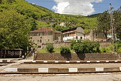
Republican Road II-16 is a 2nd class road in western Bulgaria, running through the territory of Vratsa, Sofia and Sofia City Provinces. Its length is 88 km. Throughout its entire length almost parallel to the road runs a section of section of railway line No. 2 Sofia–Mezdra–Gorna Oryahovitsa–Shumen–Varna served by the Bulgarian State Railways.
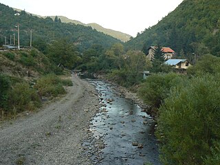
The Batuliyska reka is a 40 km-long river in western Bulgaria, a right tributary of the river Iskar.