
Earl's Court is a district of Kensington in the Royal Borough of Kensington and Chelsea in West London, bordering the rail tracks of the West London line and District line that separate it from the ancient borough of Fulham to the west, the sub-districts of South Kensington to the east, Chelsea to the south and Kensington to the northeast. It lent its name to the now defunct eponymous pleasure grounds opened in 1887 followed by the pre–World War II Earls Court Exhibition Centre, as one of the country's largest indoor arenas and a popular concert venue, until its closure in 2014.
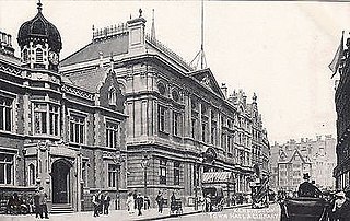
The Metropolitan Borough of Kensington was a metropolitan borough in the County of London from 1900 to 1965, which since 1901 was known as the Royal Borough of Kensington, following the death of Queen Victoria, in accordance with her wishes.

South Kensington is a district just west of Central London in the Royal Borough of Kensington and Chelsea. Historically it settled on part of the scattered Middlesex village of Brompton. Its name was supplanted with the advent of the railways in the late 19th century and the opening and naming of local tube stations. The area has many museums and cultural landmarks with a high number of visitors, such as the Natural History Museum, the Science Museum and the Victoria and Albert Museum. Adjacent affluent centres such as Knightsbridge, Chelsea and Kensington, have been considered as some of the most exclusive real estate in the world.

Brompton Cemetery is since 1852 the first London cemetery to be Crown property, managed by The Royal Parks, in West Brompton in the Royal Borough of Kensington and Chelsea. It is one of the Magnificent Seven cemeteries. Established by Act of Parliament and laid out in 1839, it opened in 1840. Consecrated by Charles James Blomfield, Bishop of London, in June 1840, it is one of Britain's oldest and most distinguished garden cemeteries. Some 35,000 monuments, from simple headstones to substantial mausolea, mark more than 205,000 resting places. The site includes large plots for family mausolea, and common graves where coffins are piled deep into the earth. It also has a small columbarium, and a secluded Garden of Remembrance at the northern end for cremated remains. The cemetery continues to be open for burials. It is also known as an urban haven for nature. In 2014, it was awarded a National Lottery grant to carry out essential restoration and develop a visitor centre, among other improvements. The restoration work was completed in 2018.

Brompton Road is a street located in the southern part from Knightsbridge and in the eastern part from Brompton in the Royal Borough of Kensington and Chelsea and partly the City of Westminster in London.

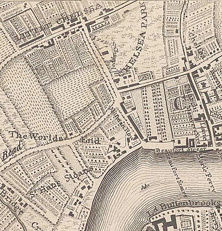
Brompton, sometimes called Old Brompton, survives in name as a ward in the Royal Borough of Kensington and Chelsea in London. Until the latter half of the 19th century it was a scattered village made up mostly of market gardens in the county of Middlesex. It lay southeast of the village of Kensington, abutting the parish of St Margaret's, Westminster at the hamlet of Knightsbridge to the northeast, with Little Chelsea to the south. It was bisected by the Fulham Turnpike, the main road westward out of London to the ancient parish of Fulham and on to Putney and Surrey. It saw its first parish church, Holy Trinity Brompton, only in 1829. Today the village has been comprehensively eclipsed by segmentation due principally to railway development culminating in London Underground lines, and its imposition of station names, including Knightsbridge, South Kensington and Gloucester Road as the names of stops during accelerated urbanisation, but lacking any cogent reference to local history and usage or distinctions from neighbouring settlements.

West Brompton is an area of west London, England, that straddles the boundary between the London Borough of Hammersmith and Fulham and Royal Borough of Kensington and Chelsea. The centuries-old boundary traced by Counter's Creek, probably marked the eastern edge of Fulham Manor since Saxon times and is now partly lost beneath the West London Line railway.
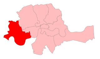
Chelsea was a borough constituency, represented in the House of Commons of the Parliament of the United Kingdom.

Bolton's Theatre Club in Drayton Gardens, Brompton, London launched in 1947 in a building originally opened in 1911 as the Radium Picture Playhouse. By operating as a club where membership was obligatory, the theatre was able to stage plays which might otherwise be prohibited under the Theatres Act 1843. Many of its plays transferred to the West End.

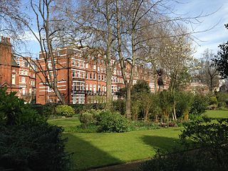
The Boltons is a street and garden square of lens shape in the Brompton district of the Royal Borough of Kensington and Chelsea, London, England. The opposing sides of the street face the communal gardens with large expansive houses and gardens, in what is considered the second most expensive street in the country with an average house price of £23.1m. The elliptical central gardens of the Boltons are Grade II listed on the Register of Historic Parks and Gardens.

Redcliffe Square, nestled in the prestigious Boltons Conservation Area of Chelsea, is a peaceful and scenic town square known for its rich historical character and lush, meticulously maintained gardens and its Victorian and Second Empire-style mansion blocks. It is located in the Brompton area of the Royal Borough of Kensington and Chelsea, southwest of central London,. Redcliffe Square Gardens are located in the square. The development was part of the vast Gunter estate, during 1864–1878.
Little Chelsea was a hamlet, located on either side of Fulham Road, half a mile Southwest of Chelsea, London. The earliest references to the settlement date from the early 17th century, and the name continued to be used until the hamlet was surrounded by residential developments in the late 19th century.
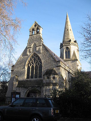
St Mary The Boltons is an Anglican church in The Boltons, Brompton, London. It is a Grade II listed building.

The Bedford Estate is an estate in central London owned by the Russell family, which holds the peerage title of Duke of Bedford. The estate was originally based in Covent Garden, then stretched to include Bloomsbury in 1669. The Covent Garden property was sold for £2 million in 1913 by Herbrand Russell, 11th Duke of Bedford, to the MP and land speculator Harry Mallaby-Deeley, who sold his option to the Beecham family for £250,000; the sale was finalised in 1918.

Onslow Square is a garden square in South Kensington, London, England.
James Gunter was an English confectioner, market gardener and property developer who laid the foundations for what became one of the great residential estates in West London, developed by his descendants, the "Redcliffe Estate" and The Boltons in Little Chelsea and West Brompton.

The Pettiward Estate is a privately owned set of reversions in the far edge of two inner boroughs of south-west London, England, now owned by a family trust of the family, who were from 1794 until 1935 of Finborough Hall, Suffolk. The family oversaw and took a direct involvement in much of the speculative development of these areas: parts of West Brompton and small parts of Putney.
Egerton Gardens is a street and communal garden, regionally termed a garden square, in South Kensington, London SW3.

Warwick Road is located in the Earl's Court district of the Royal Borough of Kensington & Chelsea in London. The road began to be laid out around 1822 and was gradually extended south to Old Brompton Road over a number of decades. It is a major north–south traffic route in west London.
The Princess Beatrice Hospital was a London hospital located in Earl's Court, which operated from 1887 to 1978, latterly as a maternity hospital.
