The Deep Freeze Range is a rugged mountain range, over 128 km (80 mi) long and about 16 km (10 mi) wide, rising between Priestley and Campbell Glaciers in Victoria Land, Antarctica, and extending from the edge of the polar plateau to Terra Nova Bay. Peaks in the low and mid portions of the range were observed by early British expeditions to the Ross Sea.

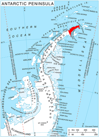
James Ross Island is a large island off the southeast side and near the northeastern extremity of the Antarctic Peninsula, from which it is separated by Prince Gustav Channel. Rising to 1,630 metres (5,350 ft), it is irregularly shaped and extends 64 km in a north–south direction. It was charted in October 1903 by the Swedish Antarctic Expedition under Otto Nordenskiöld, who named it for Sir James Clark Ross, the leader of a British expedition to this area in 1842 that discovered and roughly charted a number of points along the eastern side of the island. The style, "James" Ross Island is used to avoid confusion with the more widely known Ross Island in McMurdo Sound.


Borchgrevink Glacier is a large glacier in the Victory Mountains, Victoria Land, draining south between Malta Plateau and Daniell Peninsula, and thence projecting into Glacier Strait, Ross Sea, as a floating glacier tongue, the Borchgrevink Glacier Tongue, just south of Cape Jones. It was named by the New Zealand Geological Survey Antarctic Expedition, 1957–58, for Carsten Borchgrevink, leader of the British Antarctic Expedition, 1898–1900. Borchgrevink visited the area in February 1900 and first observed the seaward portion of the glacier.
Acosta Glacier is a glacier about 2 miles (3 km) long flowing north from Thurston Island just east of Dyer Point in Antarctica. It was named by the Advisory Committee on Antarctic Names (US-ACAN) after Alex V. Acosta of the United States Geological Survey (USGS) in Flagstaff, Arizona. He is a computer and graphic specialist, and was part of the USGS team that compiled the 1:5,000,000-scale Advanced Very High Resolution Radiometer satellite image maps of Antarctica and the 1:250,000-scale Landsat image maps of the Siple Coast area in the 1990s.
Prevot Island is a small rocky island 0.5 nautical miles (0.9 km) northeast of Miller Island, forming the northernmost of the Wauwermans Islands, in the Wilhelm Archipelago. The name was approved by the Argentine geographic coordinating committee in 1956, replacing the provisional toponym "Fernando." Named in memory of First Lieutenant Prevot, commander of the mobile detachment in the operations of the Argentine Air Force unit for Antarctica. He died on active duty.

Breitfuss Glacier is a glacier 10 nautical miles (19 km) long, which flows southeast from Avery Plateau into Mill Inlet to the west of Cape Chavanne, on the east coast of Graham Land. It was charted by the Falkland Islands Dependencies Survey (FIDS) and photographed from the air by the Ronne Antarctic Research Expedition in 1947. It was named by the FIDS for Leonid Breitfuss, a German polar explorer, historian, and author of many polar bibliographies.
Butler Passage is a passage between the Wauwermans Islands and the Puzzle Islands, connecting Peltier Channel and Lemaire Channel, off the west coast of Graham Land. The route was probably first used by the French Antarctic Expedition under Jean-Baptiste Charcot, 1903–05 and 1908–10, on their trips between Port Lockroy and Booth Island. It was named by the UK Antarctic Place-Names Committee in 1959 for Captain Adrian R.L. Butler, Royal Navy, captain of the British naval guardship HMS Protector which was in this area in 1957–58 and 1958–59.
Cayley Glacier is a glacier flowing northwest into the south side of Brialmont Cove, on the west coast of Graham Land.

Whitecloud Glacier is a glacier which flows northward between Klokotnitsa Ridge on the east and Tsarevets Buttress on the west to discharge into Charcot Bay just west of Almond Point, Trinity Peninsula. Named by United Kingdom Antarctic Place-Names Committee (UK-APC) in 1960. The name is descriptive of cloud conditions that prevailed at the time of Falkland Islands Dependencies Survey (FIDS) survey of the area in 1948.
Knight Island is an island 1.5 nautical miles (3 km) long, lying 1 nautical mile (2 km) west of Reeve Island in the Wauwermans Islands, in the Wilhelm Archipelago, Antarctica. The island was shown on an Argentine government chart of 1950. It was named by the UK Antarctic Place-Names Committee in 1958 after The Knight, one of the characters in Chaucer's The Canterbury Tales.
Guido Island is an island lying 1 nautical mile (2 km) northeast of Prioress Island in the Wauwermans Islands, in the Wilhelm Archipelago, Antarctica. It was shown on an Argentine government chart of 1950; the name "Isla Guido Spano" appears on a 1957 chart and is for Carlos Guido Spano (1829–1918), a famous Argentine poet.
Cape Errera is a cape which forms the southwest end of Wiencke Island, in the Palmer Archipelago. It was discovered by the Belgian Antarctic Expedition, 1897–99, and named by Gerlache for Leo Errera, Paul Errera, and Madame M. Errera, contributors to the expedition.
Friar Island is an island lying immediately northeast of Manciple Island in the Wauwermans Islands, in the Wilhelm Archipelago. It was shown on an Argentine government chart of 1952, but not named. It was named by the UK Antarctic Place-Names Committee in 1958 after The Friar, one of the characters in Geoffrey Chaucer's The Canterbury Tales.

Loqui Point is a point at the northern extremity of Velingrad Peninsula on the west coast of Graham Land, Antarctica. It marks the south side of the entrance to Barilari Bay. This feature was discovered and named "Cap Garcia" by the French Antarctic Expedition, 1903–05, under Jean-Baptiste Charcot. At the same time Charcot gave the name "Cap Loqui" to the north cape of Barilari Bay, after a Captain Loqui of the Argentine Navy. The maps of Charcot's French Antarctic Expedition of 1908–10, showed "Cap Garcia" as the north cape of Barilari Bay, and the name Cape Garcia has since become established in that position. Charcot did not use the name "Cap Loqui" on the maps of the 1908–10 expedition, and with his shifting of the name Cape Garcia, this south entrance point to Barilari Bay had remained unnamed. For the sake of historical continuity, the name Loqui Point was accepted for this feature in the 1950s.
Loaf Rock is a rock lying 3 nautical miles (6 km) west of Biscoe Point, off the southwest coast of Anvers Island in the Palmer Archipelago, Antarctica. It was surveyed by the British Naval Hydrographic Survey Unit in 1956–57, and was so named by the UK Antarctic Place-Names Committee in 1958 because the rock is shaped like a flat loaf of bread.
Manciple Island is an island lying between Reeve Island and Host Island in the Wauwermans Islands, in the Wilhelm Archipelago of Antarctica. It was shown on an Argentine government chart of 1952. The island was named by the UK Antarctic Place-Names Committee in 1958 after the Manciple, one of the characters in Geoffrey Chaucer's The Canterbury Tales.
Host Island is an island lying immediately southeast of Manciple Island in the Wauwermans Islands, in the Wilhelm Archipelago, Antarctica. It was shown on an Argentine government chart of 1950. The island was named by the UK Antarctic Place-Names Committee in 1958 after The Host, one of the characters in Chaucer's The Canterbury Tales.
Mount Reeves is a mountain, 1,920m, immediately northeast of Mount Bouvier on the east side of Adelaide Island. First sighted and roughly surveyed in 1909 by the French Antarctic Expedition under Charcot. Resurveyed in 1948 by the Falkland Islands Dependencies Survey (FIDS) and named by them for Edward A. Reeves, Map-curator and Instructor in Survey at the Royal Geographical Society, 1900–33.


