Regalbuto

Last updated
Regalbuto
Comune di Regalbuto
Regalbuto-Panorama.JPG
Location of Regalbuto
Regalbuto
Italy provincial location map 2016.svg
Red pog.svg
Regalbuto
Location of Regalbuto in Italy
Italy Sicily location map IT.svg
Red pog.svg
Regalbuto
Regalbuto (Sicily)
Coordinates: 37°38′58.53″N14°38′22.55″E / 37.6495917°N 14.6395972°E / 37.6495917; 14.6395972 Coordinates: 37°38′58.53″N14°38′22.55″E / 37.6495917°N 14.6395972°E / 37.6495917; 14.6395972
Country Italy
Region Sicily
Province Enna (EN)
Government
  MayorFrancesco Bivona
Area
[1]
  Total17,029 km2 (6,575 sq mi)
Elevation
520 m (1,710 ft)
Population
 (30 November 2017) [2]
  Total7,196 [3]
Demonym Regalbutesi
Time zone UTC+1 (CET)
  Summer (DST) UTC+2 (CEST)
Postal code
94017
Dialing code 0935
Patron saint Saint Vitus the martyr
Saint day11 August
Website Official website

Regalbuto (Latin: Ameselum; Sicilian: Regarbutu) is a comune in the province of Enna, Sicily, southern Italy.

Contents

There is an annual cattle fair held in the month of August.

History

Regalbuto may be the ancient town of Amaselos , which was named by the Greek and Sicilian historian Diodorus Siculus in his Bibliotheca historica (Historical Library) writings.

The name Regalbuto derives from the Arab term Rahal Abbud, "Abbud's farmhouse". Discoveries at the site include the old Saracen quarter.

Around 1200, the inhabitants of the nearby town of Centuripe, who rebelled against the Swabian dynasty whom Regalbuto had been faithful to, destroyed Regalbuto. Years later, King Manfred had the town rebuilt at its present site.

In 1860, a number of members of parliament met in Regalbuto with Garibaldi to discuss a truce during the Campaign of 1860.

The town was never subject to fiscal taxes, and a free magistracy elected by the king and the archbishops of Messina governed it. The town was severely damaged during World War II, and on August 3, 1943 the Pionier Battalion of Hermann Göring Panzer Division, supported by tanks and self-propelled guns was forced to cede the town, after four days of bitter fighting by the 1st Infantry Brigade of 1st Canadian Infantry Division. The current inhabited center was reconstructed only recently.

Main sights

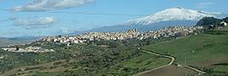
In the city environs are sites of naturalistic interest like the Pozzillo Lake district, one of Europe's largest man-made lakes, fed by the Salso River. Mountains include the Monte Mascari (863 metres (2,831 ft)), north of the lake, and, also in the lake vicinity, the Monte Salici (1,442 metres (4,731 ft)).

Economy

The economy is based on agriculture, including cereals, citrus, and olives. Animal husbandry includes cattle, sheep, and goats.

Related Research Articles

<span class="mw-page-title-main">Noto</span> City in Sicily, Italy

Noto is a city and comune in the Province of Syracuse, Sicily, Italy. It is 32 kilometres (20 mi) southwest of the city of Syracuse at the foot of the Iblean Mountains. It lends its name to the surrounding area Val di Noto. In 2002 Noto and its church were declared a UNESCO World Heritage Site.

<span class="mw-page-title-main">Taormina</span> Comune in Sicily, Italy

Taormina is a comune (municipality) in the Metropolitan City of Messina, on the east coast of the island of Sicily, Italy. Taormina has been a tourist destination since the 19th century. Its beaches on the Ionian sea, including that of Isola Bella, are accessible via an aerial tramway built in 1992, and via highways from Messina in the north and Catania in the south. On 26–27 May 2017 Taormina hosted the 43rd G7 summit.

<span class="mw-page-title-main">Province of Ragusa</span> Province in Sicily, Italy

The Province of Ragusa was a province in the autonomous region of Sicily in southern Italy, located in the south-east of the island. Following the abolition of the Sicilian provinces, it was replaced in 2015 by the Free municipal consortium of Ragusa. Its capital is the city of Ragusa, which is the most southerly provincial capital in Italy.

<span class="mw-page-title-main">Ragusa, Sicily</span> City in Sicily, Italy

Ragusa is a city and comune in southern Italy. It is the capital of the province of Ragusa, on the island of Sicily, with 73,288 inhabitants in 2016. It is built on a wide limestone hill between two deep valleys, Cava San Leonardo and Cava Santa Domenica. Together with seven other cities in the Val di Noto, it is part of a UNESCO World Heritage Site.

<span class="mw-page-title-main">Caltanissetta</span> Municipality in Sicily, Italy

Caltanissetta is a comune in the central interior of Sicily, Italy, and the capital of the Province of Caltanissetta. Its inhabitants are called Nisseni.

<span class="mw-page-title-main">Licata</span> Comune in Sicily, Italy

Licata, formerly also Alicata, is a city and comune located on the south coast of Sicily, at the mouth of the Salso River, about midway between Agrigento and Gela. It is a major seaport developed at the turn of the twentieth century, shipping sulphur, the refining of which has made Licata the largest European exporting centre, and asphalt, and at times shipping cheese.

<span class="mw-page-title-main">Monte Isola</span> Comune in Lombardy, Italy

Monte Isola is a town and comune in the province of Brescia, in Lombardy.

<span class="mw-page-title-main">Caltagirone</span> Comune in Sicily, Italy

Caltagirone is an inland city and comune in the Metropolitan City of Catania, on the island of Sicily, southern Italy, about 70 kilometres (43 mi) southwest of Catania. It is the fifth most populous municipality of the Metropolitan City, behind Catania, Acireale, Misterbianco and Paternò. Alongside Catania, it is the only town who is seat of a tribunal in the former province. Since 1987, the comune has obtained the City title, through presidential act. After Caltanissetta, it is the second most populous comune in Central Sicily.

<span class="mw-page-title-main">Palazzolo Acreide</span> Comune in Sicily, Italy

Palazzolo Acreide is a town and comune in the Province of Syracuse, Sicily. It is 43 kilometres (27 mi) from the city of Syracuse in the Hyblean Mountains.

<span class="mw-page-title-main">Agira</span> Comune in Sicily, Italy

Agira is a town and comune in the province of Enna, Sicily. It is located in the mid-valley of the River Salso, 35 kilometres from Enna. Until 1861 it was called San Filippo d'Argiriò, in honour of its saint Philip of Agira.

<span class="mw-page-title-main">Riva del Garda</span> Comune in Trentino-Alto Adige/Südtirol, Italy

Riva del Garda is a town and comune in the northern Italian province of Trento of the Trentino Alto Adige region. It is also known simply as Riva and is located at the northern tip of Lake Garda.

<span class="mw-page-title-main">Modica</span> Comune in Sicily, Italy

Modica is a city and comune of 54,456 inhabitants in the Province of Ragusa, Sicily, southern Italy. The city is situated in the Hyblaean Mountains.

<span class="mw-page-title-main">San Miniato</span> Comune in Tuscany, Italy

San Miniato is a town and comune in the province of Pisa, in the region of Tuscany, Italy.

<span class="mw-page-title-main">Venafro</span> Comune in Molise, Italy

Venafro is a comune in the province of Isernia, region of Molise, Italy. It has a population of 11,079, having expanded quickly in the post-war period.

<span class="mw-page-title-main">Cerami</span> Comune in Sicily, Italy

Cerami is a comune in Sicily, southern Italy, part of the Province of Enna. The town itself is perched on a mountaintop 1,000 metres (3,300 ft) above sea level. A river also named Cerami flows through this area.

<span class="mw-page-title-main">Valguarnera Caropepe</span> Comune in Sicily, Italy

Valguarnera Caropepe is a comune in Province of Enna, Sicily, southern Italy. Valguarnera Caropepe stands at an elevation of 590 metres (1,940 ft) above sea level in a hilly area of the province.

<span class="mw-page-title-main">Bugnara</span> Comune in Abruzzo, Italy

Bugnara is a comune and village in the province of L'Aquila in the Abruzzo region of central Italy. In 2007, it was designated as one of the most beautiful villages in Italy, an association that notes small Italian towns of artistic and historical interest.

<span class="mw-page-title-main">Crognaleto</span> Comune in Abruzzo, Italy

Crognaleto is a comune and city of slightly less than 2,000 people in the Province of Teramo, central Italy. Crognaleto sits at an elevation of 1,105 metres (3,625 ft) and has its communal administrative offices in the frazione of Nerito. The commune of Crognaleto sits on the slopes of the Monti della Laga mountain range and extends across both the northern and the southern slopes of the Vomano Valley. It lies within the Gran Sasso e Monti della Laga National Park.

<span class="mw-page-title-main">Malcesine</span> Comune in Veneto, Italy

Malcesine is a comune (municipality) on the eastern shore of Lake Garda in the Province of Verona in the Italian region Veneto, located about 120 kilometres northwest of Venice and about 40 kilometres northwest of Verona.

<span class="mw-page-title-main">Pietrabbondante</span> Comune in Molise, Italy

Pietrabbondante is a comune (municipality) in the Province of Isernia in the Italian region Molise, located about 30 kilometres (19 mi) northwest of Campobasso and about 20 kilometres (12 mi) northeast of Isernia.

References

  1. "Superficie di Comuni Province e Regioni italiane al 9 ottobre 2011". Italian National Institute of Statistics. Retrieved 16 March 2019.
  2. "Popolazione Residente al 1° Gennaio 2018". Italian National Institute of Statistics. Retrieved 16 March 2019.
  3. All demographics and other statistics: Italian statistical institute Istat.