Tropical cyclones and subtropical cyclones are named by various warning centers to provide ease of communication between forecasters and the general public regarding forecasts, watches, and warnings. The names are intended to reduce confusion in the event of concurrent storms in the same basin. Generally once storms produce sustained wind speeds of more than 33 knots, names are assigned in order from predetermined lists depending on which basin they originate. However, standards vary from basin to basin: some tropical depressions are named in the Western Pacific, while tropical cyclones must have a significant amount of gale-force winds occurring around the centre before they are named in the Southern Hemisphere.
Tropical cyclone warnings and watches are two levels of alert issued by national weather forecasting bodies to coastal areas threatened by the imminent approach of a tropical cyclone of tropical storm or hurricane intensity. They are notices to the local population and civil authorities to make appropriate preparation for the cyclone, including evacuation of vulnerable areas where necessary. It is important that interests throughout the area of an alert make preparations to protect life and property, and do not disregard it on the strength of the detailed forecast track. Tropical cyclones are not points, and forecasting their track remains an uncertain science.
Tropical cyclones are ranked on one of five tropical cyclone intensity scales, according to their maximum sustained winds and which tropical cyclone basin(s) they are located in. Only a few scales of classifications are used officially by the meteorological agencies monitoring the tropical cyclones, but some alternative scales also exist, such as accumulated cyclone energy, the Power Dissipation Index, the Integrated Kinetic Energy Index, and the Hurricane Severity Index.
Météo-France is the French national meteorological service.

The 2007–08 South Pacific cyclone season was one of the least active South Pacific tropical cyclone season's on record, with only four tropical cyclones occurring within the South Pacific basin to the east of 160°E. The season officially ran from November 1, 2007 until April 30, 2008, although the first cyclone, Tropical Depression 01F, developed on October 17. The most intense tropical cyclone of the season was Severe Tropical Cyclone Daman, which reached a minimum pressure of 925 hPa (27.32 inHg) as it affected Fiji. After the season had ended, the names Daman, Funa, and Gene were retired from the tropical cyclone naming lists.
The 2003–04 South Pacific cyclone season was a below-average season with only three tropical cyclones occurring within the South Pacific to the east of 160°E. The season officially ran from November 1, 2003 to April 30, 2004 with the first disturbance of the season forming on December 4 and the last disturbance dissipating on April 23. This is the period of the year when most tropical cyclones form within the South Pacific Ocean.

In the south-west Indian Ocean, tropical cyclones form south of the equator and west of 90° E to the coast of Africa.
The 2010–11 South Pacific cyclone season was an average tropical cyclone season, with seven tropical cyclones and five severe tropical cyclones developing during the season. The season ran from November 1, 2010 until April 30, 2011, though if any tropical cyclones had developed between July 1, 2010 and June 30, 2011, the official tropical cyclone year, they would have been counted towards the season's total. Within the South Pacific basin tropical cyclones were officially monitored by the Fiji Meteorological Service's Regional Specialized Meteorological Center in Nadi, Fiji, north of 25°S, and to the south the Meteorological Service of New Zealand's Tropical Cyclone Warning Center in Wellington, New Zealand. Any disturbances forming in the region were designated with a sequential number suffixed by the letter F. In addition, the United States Military's Joint Typhoon Warning Center unofficially monitored parts of the basin during the season, where any systems judged to have achieved tropical storm strength or greater received a number suffixed with the letter P. RSMC Nadi and TCWC Wellington both use the Australian Tropical Cyclone Intensity Scale, and measure wind speeds over a period of ten minutes, while the JTWC measures sustained winds over a period of one minute which can be applied to the Saffir–Simpson Hurricane Scale. Seven named storms formed or moved into the South Pacific basin during the 2010–11 season, the strongest of which was Severe Tropical Cyclone Wilma in late January.
Tropical cyclones of 2010 were spread across seven oceanic basins in their respective seasons; the strongest of these tropical cyclones was Typhoon Megi, which strengthened to a minimum barometric pressure of 885 mbar before striking the east coast of Luzon in the Philippines. Regional Specialized Meteorological Centers (RSMC) and Tropical Cyclone Warning Centers (TCWC) designated names to 70 systems worldwide, of which 46 occurred in the northern hemisphere while 21 developed in the southern hemisphere. The most active basin in 2010 was the North Atlantic, which documented 19 named systems, while the North Indian Ocean, despite only amounting to five named systems, was its basin's most active since 1998. Conversely, both the West Pacific typhoon and East Pacific hurricane seasons experienced the least number of cyclones reaching tropical storm intensity in recorded history, numbering 14 and 8, respectively. Activity across the southern hemisphere's three basins—South-West Indian, Australian, and South Pacific—was spread evenly, with each region recording seven named storms apiece. That hemisphere's strongest tropical cyclone was Cyclone Edzani, which bottomed out with a barometric pressure of 910 mbar in the South-West Indian Ocean.

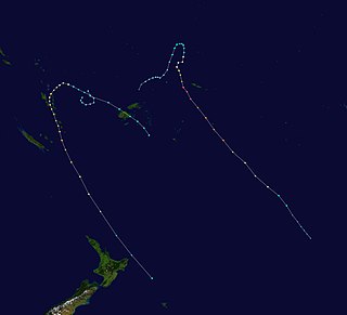
The 1995–96 South Pacific cyclone season was one of the least active South Pacific tropical cyclone season's on record, with only four tropical cyclones occurring within the South Pacific Ocean to the east of 160°E. The season officially ran from November 1, 1995, until April 30, 1996. The first storm developed on January 12, while the last one dissipated on April 2. During the season the most intense tropical cyclone was Severe Tropical Cyclone Beti, which reached a minimum pressure of 935 hPa (27.61 inHg) as it affected New Caledonia. After the season ended Beti's name was the only name to be retired from the tropical cyclone naming lists and was replaced with Bune, after it inflicted over 5.6 million (USD) worth of damage to Australia, Vanuatu, New Caledonia and New Zealand.
The 2019–20 Australian region cyclone season is the period of the year when most tropical cyclones form in the southern Indian and Pacific Oceans between 90°E and 160°E. The season will officially run from 1 November 2019 to 30 April 2020; however, a tropical cyclone could form at any time between 1 July 2019 and 30 June 2020 and would count towards the season total. During the season, tropical cyclones will be officially monitored by the Australian Bureau of Meteorology (BOM), the Indonesian Agency for Meteorology, Climatology and Geophysics (BMKG), and the National Weather Service of Papua New Guinea. The United States' Joint Typhoon Warning Center (JTWC), and other national agencies such as the Fiji Meteorological Service (FMS), the Meteorological Service of New Zealand (MetService), and Météo-France at La Réunion, will also monitor parts of the basin during the season.

The 2014–15 South Pacific cyclone season was a slightly-below average tropical cyclone season, with five tropical cyclones occurring within the basin between 160°E and 120°W. The season officially ran from November 1, 2014 to April 30, 2015. During the season, tropical cyclones were officially monitored by the Regional Specialized Meteorological Center (RSMC) in Nadi, Fiji and the Tropical Cyclone Warning Centers in Brisbane, Australia and Wellington, New Zealand. The United States Armed Forces through the Joint Typhoon Warning Center (JTWC) also monitored the basin and issued unofficial warnings for American interests. RSMC Nadi attaches a number and an F suffix to tropical disturbances that form in or move into the basin while the JTWC designates significant tropical cyclones with a number and a P suffix. RSMC Nadi, TCWC Wellington and TCWC Brisbane all use the Australian Tropical Cyclone Intensity Scale and estimate windspeeds over a period of ten minutes, while the JTWC estimated sustained winds over a 1-minute period, which are subsequently compared to the Saffir–Simpson hurricane wind scale (SSHWS).

The 1984–85 South Pacific cyclone season was an above-average tropical cyclone season, with nine tropical cyclones occurring within the basin between 160°E and 120°W. The season ran from November 1, 1984, to April 30, 1985, with tropical cyclones officially monitored by the Fiji Meteorological Service (FMS), Australian Bureau of Meteorology (BoM) and New Zealand's MetService. The United States Joint Typhoon Warning Center (JTWC) and other national meteorological services including Météo-France and NOAA also monitored the basin during the season. During the season there was nine tropical cyclones occurring within the basin, including three that moved into the basin from the Australian region. The BoM, MetService and RSMC Nadi all estimated sustained wind speeds over a period of 10-minutes, which are subsequently compared to the Australian tropical cyclone intensity scale, while the JTWC estimated sustained winds over a 1-minute period, which are subsequently compared to the Saffir–Simpson hurricane wind scale (SSHWS).

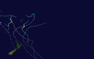
The 2015–16 South Pacific cyclone season was one of the most disastrous South Pacific tropical cyclone seasons on record, with a total of 50 deaths and $1.405 billion in damage. Throughout the season, 8 systems attained tropical cyclone status, whilst 5 became severe tropical cyclones. The most notable cyclone of the season by far was Winston, which attained a minimum pressure of 884 hPa, and maximum ten-minute sustained winds of 175 mph (280 km/h), making it the most intense tropical cyclone on record in the Southern Hemisphere. Winston went on to devastate Fiji, causing $1.4 billion in damage and 44 deaths across the country.

The 2019–20 South Pacific cyclone season is the period of the year when most tropical cyclones form within the South Pacific Ocean to the east of 160°E. The season officially runs from November 1, 2019 to April 30, 2020, however a tropical cyclone could form at any time between July 1, 2019 and June 30, 2020 and would count towards the season total. During the season, tropical cyclones will be officially monitored by the Regional Specialized Meteorological Center (RSMC) in Nadi, Fiji and the Tropical Cyclone Warning Centers in Brisbane, Australia and Wellington, New Zealand. The United States Armed Forces through the Joint Typhoon Warning Center (JTWC) will also monitor the basin and issue unofficial warnings for American interests. RSMC Nadi attaches a number and an F suffix to tropical disturbances that form in or move into the basin while the JTWC designates significant tropical cyclones with a number and a P suffix. RSMC Nadi, TCWC Wellington and TCWC Brisbane all use the Australian Tropical Cyclone Intensity Scale and estimate windspeeds over a period of ten minutes, while the JTWC estimated sustained winds over a 1-minute period, which are subsequently compared to the Saffir–Simpson hurricane wind scale (SSHWS).

Tropical cyclones in 2015 were spread out across seven different areas called basins; the strongest of these tropical cyclones was Hurricane Patricia, which strengthened to a minimum barometric pressure of 872 mbar before striking the east coast of Colima in Mexico. 133 tropical cyclones had formed this year to date. 92 tropical cyclones had been named by either a Regional Specialized Meteorological Center (RSMC) or a Tropical Cyclone Warning Center (TCWC).

Tropical cyclones in 2014 were spread out across seven different areas called basins; the strongest of these tropical cyclones was Typhoon Vongfong, which strengthened to a minimum barometric pressure of 900 mbar before striking the east coast of Japan. 117 tropical cyclones had formed this year to date. 80 tropical cyclones had been named by either a Regional Specialized Meteorological Center (RSMC) or a Tropical Cyclone Warning Center (TCWC). The most active basin in 2014 was the Western Pacific, which documented 23 named systems, while the Eastern Pacific, despite only amounting to 22 named systems, was its basin's most active since 1992. Conversely, both the North Atlantic hurricane and North Indian Ocean cyclone seasons experienced the fewest cyclones reaching tropical storm intensity in recorded history, numbering 9 and 3, respectively. Activity across the southern hemisphere's three basins—South-West Indian, Australian, and South Pacific—was spread evenly, with each region recording seven named storms apiece.

Tropical cyclones in 2016 were spread out across seven different areas called basins; the strongest of these tropical cyclones was Cyclone Winston, which strengthened to a minimum barometric pressure of 884 mbar before striking Fiji. 143 tropical cyclones had formed this year. 90 of which had been named by either a Regional Specialized Meteorological Center (RSMC) or a Tropical Cyclone Warning Center (TCWC). The most active basin in 2016 was the Western Pacific, which documented 26 named systems.
Tropical cyclones in 2004 were spread out across seven different areas called basins; the strongest of these tropical cyclones was Cyclone Gafilo, which strengthened to a minimum barometric pressure of 895 mbar becomes the most intense tropical cyclone ever recorded in the South-West Indian Ocean before striking the east coast of Madagascar. 130 tropical cyclones had formed this year to date. 81 tropical cyclones had been named by either a Regional Specialized Meteorological Center (RSMC) or a Tropical Cyclone Warning Center (TCWC). The most active basin in 2004 was the Western Pacific, which documented 29 named systems, while the North Atlantic, despite only amounting to 15 named systems, was its basin's hyperactive season since 1995. Conversely, both the Eastern Pacific hurricane and North Indian Ocean cyclone seasons experienced the least number of cyclones reaching tropical storm intensity in recorded history, numbering 12 and 4, respectively. Activity across the southern hemisphere's three basins—South-West Indian, Australian, and South Pacific—was spread evenly, with each region recording seven named storms apiece.
Tropical cyclones in 2012 were spread out across seven different areas called basins; the strongest tropical cyclone was Typhoon Sanba strengthened to a minimum barometric pressure of 900 mbar before striking South Korea. 131 tropical cyclones had formed this year to date. 88 tropical cyclones had been named by either a Regional Specialized Meteorological Center (RSMC) or a Tropical Cyclone Warning Center (TCWC). The most active basin in the year was the Western Pacific, which documented 25 named systems, while the North Atlantic Pacific, despite only amounting to 19 named systems, was its basin's hyperactive since 2010 becoming the third-most active season on record. Conversely, the Eastern Pacific hurricane season experienced the average number of cyclones reaching tropical storm intensity, numbering 17 respectively. The least tropical cyclone season was North Indian Ocean had a late start, with the first system forming in October. Activity across the southern hemisphere's three basins—South-West Indian, Australian, and South Pacific—was spread evenly, with each region recording seven named storms apiece.
