
The Harz is a highland area in northern Germany. It has the highest elevations for that region, and its rugged terrain extends across parts of Lower Saxony, Saxony-Anhalt, and Thuringia. The name Harz derives from the Middle High German word Hardt or Hart, Latinized as Hercynia. The Brocken is the highest summit in the Harz with an elevation of 1,141.1 metres (3,744 ft) above sea level. The Wurmberg is the highest peak located entirely within the state of Lower Saxony.
Goslar is a district in Lower Saxony, Germany. It is bounded by the districts of Göttingen, Northeim, Hildesheim and Wolfenbüttel, the city of Salzgitter, and by the states of Saxony-Anhalt and Thuringia (Nordhausen).
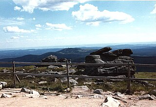
Harz National Park is a nature reserve in the German federal states of Lower Saxony and Saxony-Anhalt. It comprises portions of the western Harz mountain range, extending from Herzberg and Bad Lauterberg at the southern edge to Bad Harzburg and Ilsenburg on the northern slopes. 95 % of the area is covered with forests, mainly with spruce and beech woods, including several bogs, granite rocks and creeks. The park is part of the Natura 2000 network of the European Union.
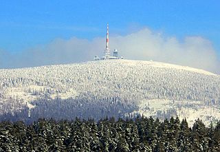
The Brocken, also sometimes referred to as the Blocksberg, is the highest peak of the Harz mountain range and also the highest peak of Northern Germany; it is located near Schierke in the German state of Saxony-Anhalt between the rivers Weser and Elbe. Although its elevation of 1,141 metres (3,743 ft) is below alpine dimensions, its microclimate resembles that of mountains of about 2,000 m (6,600 ft). The peak above the tree line tends to have a snow cover from September to May, and mists and fogs shroud it up to 300 days of the year. The mean annual temperature is only 2.9 °C (37.2 °F). It is the easternmost mountain in northern Germany; travelling east in a straight line, the next prominent elevation would be in the Ural Mountains in Russia.

Braunlage is a town and health resort in the Goslar district in Lower Saxony in Germany. Situated within the Harz mountain range, south of the Brocken massif, Braunlage's main business is tourism, particularly skiing. Nearby ski resorts include the Sonnenberg and the slopes on the Wurmberg.

Sankt Andreasberg is a former town in the district of Goslar, in Lower Saxony, Germany. Since 1 November 2011, it is part of the town Braunlage. It is situated in the Harz, approximately 7 km west of Braunlage proper, and 20 km east of Osterode am Harz.

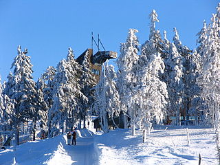
Schierke is a village and a former municipality in the Harz district, in the German state of Saxony-Anhalt. Since 1 July 2009, it is part of the town Wernigerode. Situated within the Harz mountain range in the valley of the Bode River, at the rim of the Harz National Park, it is mainly a tourist resort, especially for hiking and all kinds of winter sports.

The Oder is a 56-kilometre-long (35 mi) river in Lower Saxony, Germany, and a right tributary of the Rhume. Its source is in the Harz mountains, near Sankt Andreasberg. It flows southwest through Bad Lauterberg, Pöhlde and Hattorf am Harz. The Oder flows into the Rhume in Katlenburg-Lindau.
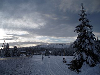
The Sonnenberg is a ski resort in the Upper Harz surrounded by the Harz National Park. The settlement of the same name located there is part of the borough of Sankt Andreasberg.

The Upper Harz refers to the northwestern and higher part of the Harz mountain range in Germany. The exact boundaries of this geographical region may be defined differently depending on the context. In its traditional sense, the term Upper Harz covers the area of the seven historical mining towns (Bergstädte) - Clausthal, Zellerfeld, Andreasberg, Altenau, Lautenthal, Wildemann and Grund - in the present-day German federal state of Lower Saxony. Orographically, it comprises the Harz catchment areas of the Söse, Innerste and Grane, Oker and Abzucht mountain streams, all part of the larger Weser watershed.

The Großer Knollen is a 687.4-metre-high (2,255 ft) mountain in the southwestern part of the Harz in Lower Saxony, Germany.
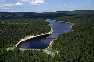
The Oderteich is an historic reservoir about seven kilometres northeast of Sankt Andreasberg in the Upper Harz in central Germany. It was built by miners from St. Andreasberg in the years 1715 to 1722 and, today, is an important component of the water supply network known as the Upper Harz Water Regale. Moreover, for 170 years, from the time it was completed to the end of the 19th century, the Oderteich had the largest dam in Germany. The dam lies at a height of 725 m above NN by the B 242 federal highway, about a kilometre west of its intersection with the B 4.

The Harz Witches' Trail is a footpath, just under 100 km long, in Germany that runs from Osterode through the Harz mountains and over its highest peak, the Brocken, to Thale. It is a project by the Harz Transport Association and Harz Club and is part of the system of trails known as the Harzer Wandernadel.

Sudmerberg is a suburb of Goslar in Lower Saxony, Germany, named after a prominent 354 m (1,161 ft)-metre-high hill to the east.

The Breitenbeek is a roughly 6.3 km (4 mi) river of Lower Saxony, in the Harz Mountains of central Germany. It is a tributary of the Sperrlutter. It rises at over 620 m in the vicinity of the Rehbergklinik in Oderberg. It then flows initially southwards through the Engelsburger Teiche, before it joins the Sperrlutter at 360 m. The Breitenbeek is the largest tributary of the Sperrlutter.

The Samson Pit or Samson Mine is an historic silver mine in Sankt Andreasberg in the Upper Harz region of central Germany.

The Koboltstaler Köpfe are a group of three mountains, that rise southwest of Sankt Andreasberg and east of Sieber in the district of Göttingen in Lower Saxony. The highest of the three peaks is 673 metres high. The other two summits lie roughly 350 metres east and south of the main peak respectively and are ony a few metres lower. The Koboltstaler Köpfe are mainly covered by pine forest and accessible on all sides by forest roads.
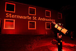
The Sankt Andreasberg Observatory, also called Harz Observatory, is a project of the charitable society Sternwarte Sankt Andreasberg e. V., which translates into Sankt Andreasberg Observatory registered society. It was opened in August 2014 and is supposed to become the first completely barrier free Observatory in Germany. The society's expressive goal is to make the sky accessible to all people, whether they are disabled or not. Celestial observation, lectures and Workshops convey general astronomical knowledge to visitors.

The Grünhirscher Stollen is an adit for water drainage in Sankt Andreasberg, in the Harz mountains. It was created during mining in the Upper Harz and named after the valley Grüner Hirsch between the mountains Galgenberg and Glockenberg. It leads from the Samson Pit to the south-west of the Galgenberg.
The Sieberstollen is an adit for water drainage in Sankt Andreasberg, in the Harz mountains. It was created during mining in the Upper Harz and named after the river Sieber into which it discharges its water. The opening position is in the Sieber Valley.


