
The Dinaric Alps, also Dinarides, are a mountain range in Southern and Southcentral Europe, separating the continental Balkan Peninsula from the Adriatic Sea. They stretch from Italy in the northwest through Slovenia, Croatia, Bosnia and Herzegovina, Serbia, Montenegro, and Kosovo to Albania in the southeast.

The Accursed Mountains, also known as the Albanian Alps, is a mountain range in coastal Southeast Europe adjacent to the Adriatic Sea. It is the southernmost subrange of the 1,000-kilometre-long (621 mi) Dinaric Alps range (Dinarides), extending from northern Albania to southern Kosovo and northeastern Montenegro. Maja Jezercë, standing at 2,694 m (8,839 ft), is the highest point of the Accursed Mountains and of all Dinaric Alps, and the fifth highest peak in Albania. The range includes the mountain Zla Kolata, which, at 2,534 m (8,314 ft), is the tallest mountain in Montenegro. The range also includes the mountain Gjeravica, which, at 2,656 m (8,714 ft), is the second tallest mountain in Kosovo. One of the southernmost glacial masses in Europe was discovered in the Albanian part of the range in 2009.
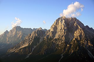
Monte Antelao is the highest mountain in the eastern Dolomites in northeastern Italy, southeast of the town of Cortina d'Ampezzo, in the region of Cadore. The Monte Antelao is an ultra-prominent peak (Ultra).

Dellach is a municipality in the district of Hermagor, in the Austrian state of Carinthia.

Maglić is a transboundary mountain in the Dinaric Alps, on the border of Bosnia and Herzegovina and Montenegro.

Shkëlzen is a mountain situated in the Albanian Alps, bounded by the Tropojë river valley to the northeast, the Gashi river valley to the southwest, and the Tropojë basin to the southeast. It is the higher of the two peaks, Maja e Shkëlzenit, reaching a height of 2,405 m (7,890 ft).
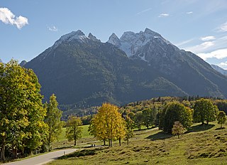
At 2,606.9 metres (8,553 ft), the Hochkalter in the Berchtesgaden Alps is the highest peak in the massif of the same name and therefore one of the highest mountains in Germany. The Hochkalter Massif is also called the Hochkalter mountains.
Creta Forata is a mountain of the Carnic Alps that lies on the border of Veneto and Friuli, northeast Italy, with an elevation of 2,462 m. It is located near the village of Sappada in the Piave Valley. Formed of limestone, it is the highest mountain of the eastern Terza - Siera Group and boasts a twin summit. It is of a similarly rugged nature as the Dolomites to the west.

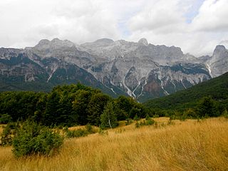
Maja e Thatë is a 2,406-metre-high (7,894 ft) mountain peak of the Albanian Alps in Albania. It is located within Valbonë Valley National Park, roughly 2 km (1 mi) northwest of Valbonë and rises more than 1,500 m (4,921 ft) above the village. The mountain's southern and western lower slopes are relatively rich in beech and pine forests, while the higher slopes consist of very steep dolomite and limestone rock walls, suitable for mountaineering and rock climbing.

The Carnic and Gailtal Alps is a geographic grouping of mountain ranges belonging to the Southern Limestone Alps. They are located in Austria and Italy.

The Gurktal Alps is a mountain range in the Central Eastern Alps in Austria which is named after the valley of the Gurk river. The range stretches west to Lake Millstatt and east to Neumarkter Sattel. The highest peak is Eisenhut at 2,441m .
The Gailtaler Polinik is a mountain, 2,332 m above sea level (AA), in the Carnic Alps in the Austrian state of Carinthia. It lies on the main ridge of the Carnics and is the highest peak of the Eastern group.

The Gailtal Alps, is a mountain range of the Southern Limestone Alps in Austria. It rises between the River Drava (Drau) and the Gail valley and through the southern part of East Tyrol. Its western group called "Lienz Dolomites", is sometimes counted as part of this range and sometimes seen as separate.

The Lienz Dolomites are an alpine mountain range located in the Austrian states of East Tyrol and Carinthia. It lies at the western side of the wider Gailtal Alps and contains its highest peaks. The range lies between the Drau Valley in the north and the Gail Valley to the south.

The Hochalmspitze is located east of Mallnitz in the Austrian state of Carinthia. It is sometimes called "Tauern Queen" as a counterpart to the "Tauern King", the Grossglockner.

Trogkofel is a mountain of the Carnic Alps lying on the border of Friuli, Italy and Carinthia, Austria. It is located on the main ridge of the Carnics between the Aip Valley to the south and the Gail Valley in the north, and is the second highest mountain on the eastern ridge after Gailtaler Polinik. The mountain is known as Crete Rosse, meaning Red Rocky Mountain in Friuli.
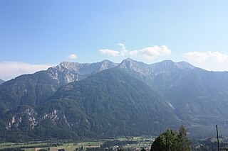
Torkofel is a mountain of the Gailtal Alps in Carinthia, Austria. It is the highest summit of the Jauken Group, a small limestone massif west of Reißkofel. It lies between the Drava valley to the north and the Gail valley in the south. It was first climbed in 1853 by the Johann Festin von Wald and Paul Grohmann.

Latschur, at 2,236 m (7,336 ft), is the highest mountain of the Latschur Group in the Gailtal Alps range, in the Austrian state of Carinthia.

Sorapiss, also referred to as Sorapis or Punta Sorapiss, is a mountain in the Dolomites within the Veneto region of northern Italy. Situated in the comune of Cortina d'Ampezzo, it has an elevation of 3,205 metres (10,515 ft). In its vicinity is a mountain pass of the same name, as well as Sorapiss Lake, at the foot of the mountain. The mountain range is part of the Ampezzo Dolomites Natural Park.
Radohina is a massif situated in the Albanian Alps, within the boundaries of Shkodër municipality. Its main peak, Maja e Radohinës, reaches a height of 2,568 m (8,425 ft).

