
Blue Spring Heritage Center is a 33-acre (13 ha) privately owned tourist attraction in the Arkansas Heritage Trails System containing native plants and hardwood trees in a setting of woodlands, meadows, and hillsides. It is located at Highway 62 West, five miles (8 km) west of Eureka Springs, Arkansas, and open daily to the public during warmer months for a fee.

The McDonald's Sign, also known as McDonald's Store #433 Sign, in Pine Bluff, Arkansas, United States, is one of only a few surviving examples of a single-arch McDonald's sign. The sign was erected in 1962 and remained at its original location until 2007. That year, McDonald's Store #433 moved and the sign was renovated and moved to the new location. The McDonald's sign was added to the U.S. National Register of Historic Places in 2006.

The Community Theatre is a historic theatre building at 207 West 2nd Avenue in Pine Bluff, Arkansas. It is a two-story brick building, finished in stucco, with Moderne styling. It was built in 1889, and housed first a furniture store, and then a five and dime, before being converted for theatrical use in the 1920s. Its present Moderne styling dates to renovations made in the wake of a 1951 fire.

The Strengthen the Arm of Liberty Monument is a replica of the Statue of Liberty in Pine Bluff Memorial Gardens, on the south side of 10th Avenue between Georgia and State Street in Pine Bluff, Arkansas. It was placed by the Boy Scouts of America (BSA) as part of its 1950s era campaign, "Strengthen the Arm of Liberty." The statue is 8 feet (2.4 m) in height, made of copper, and is mounted on concrete base 3.5 feet (1.1 m) tall. The statue faces north, toward the Pine Bluff Civic Center, and there is a bronze commemorative plaque on the north face of the base. It is one of two BSA-placed statues in the state; the other is in Fayetteville.
Crocketts Bluff is an unincorporated community in Arkansas County, Arkansas, United States. It is the location of Crocketts Bluff Hunting Lodge, which is located at the end of the dirt road north of the point at which AR 153 turns south, and is listed on the National Register of Historic Places. Crocketts Bluff sits at an elevation of 171 feet the highest point in Arkansas County. The ZIP Code for Crocketts Bluff is 72038.

Couchwood is the summer estate of Harvey C. Couch, an industrialist and founder of Arkansas Power and Light in the early 20th century. The estate, located at 601 Couchwood Road, is southeast of Hot Springs, Arkansas, straddling the border of Garland and Hot Spring counties on the north shore of Lake Catherine.
Lake Dick is an unincorporated community in Jefferson County, Arkansas, United States. Lake Dick is northeast of Pine Bluff and south of Altheimer.

This is a list of the National Register of Historic Places listings in Jefferson County, Arkansas.

The Masonic Temple is a historic fraternal and commercial building at East Fourth Avenue and State Street in Pine Bluff, Arkansas. Fundraising for the building was led by Joseph Carter Corbin and J. N. Donohoo. It is a four-story brick building, built between 1902 and 1904 by the state's African-American Masonic lodge, the Sovereign Grand Lodge of Free and Accepted Masons. It was at the time Pine Bluff's tallest building; the ground floor held retail space, the second floor professional offices, and the upper floors were devoted to the Masonic organizations.

Highway 190 is a designation for four state highways in Arkansas. Three are low-traffic rural highways in Grant County, with one designation along city streets in Pine Bluff. The rural segments were created in 1965 and 1966, with the Pine Bluff section created in 2000 as a renumbering of Highway 104. All segments are maintained by the Arkansas Department of Transportation (ARDOT).
Tates Bluff is an unincorporated community in Ouachita County, Arkansas, United States. Tates Bluff is located near the northern border of Ouachita County, 15.2 miles (24.5 km) north-northwest of Camden. The Tate's Bluff Fortification, which is listed on the National Register of Historic Places, is located near Tates Bluff.

Union Station is a former railroad station at East 4th Ave. and State St. in Pine Bluff, Jefferson County, Arkansas. The station was originally at the union of the Cotton Belt and Iron Mountain railroads, and now houses the Pine Bluff/Jefferson County Historical Society museum. It is a single-story brick building, with a hip roof whose long eaves are supported by iron columns and half-truss brackets. The station was built in 1906 by the Iron Mountain Railroad. It had been a stop on the St. Louis Southwestern's Lone Star (Memphis-Dallas), and also on the railway's St. Louis-Dallas trains.

Mt. Zion Presbyterian Church is a historic church on Arkansas Highway 81 in Relfs Bluff, Arkansas. The single story wood-frame structure was built in 1925, and exhibits Craftsman styling with some Classical Revival detailing. The main facade has a gable end with brackets above a recessed entry with Tuscan columns. The wall is finished in flushboarding incised with a carved arch motif. The side elevations each have a central projecting section, which is topped by a gable dormer with three windows. The roof has wide eaves with exposed rafters. The interior has retained all of its original finishes, although the ceiling has been covered by asbestos tiles. The church was built for a congregation established in 1859.

St. Elizabeth's Catholic Church is a historic church at the northeast corner of Sycamore and Mason Streets in DeValls Bluff, Arkansas in the United States. It was built in 1912 and added to the National Register of Historic Places in 2009.
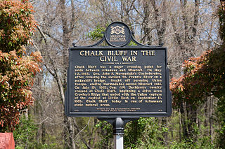
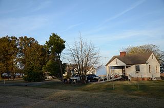
Chalk Bluff was an unincorporated community in Clay County, Arkansas, United States, approximately two miles (3 km) northwest of St. Francis. The town was formed in the 1820s at the point where the St. Francis River cuts through Crowley's Ridge from west to east. The name of the community was derived from the white clay bluff created by this crossing. The founder of the community was Abraham Seitz, who established and operated a ferry crossing and general store in the area from the 1830 until it was destroyed during the Civil War. The community occupied a strategic location and was often referred to in the reports of Union and Confederate forces vying for control of Northeast Arkansas during the war. Several skirmishes occurred near the ferry crossing, one of which was significant it enough to become known as the Battle of Chalk Bluff, which took place in early May 1863. The town was abandoned following the Civil War and most residents moved to the new railroad town, St. Francis, Arkansas. The location was listed on the National Register of Historic Places in 1974.

The Jefferson County Courthouse is the center of county government for Jefferson County, Arkansas. It is located in the Pine Bluff Commercial Historic District in Pine Bluff on the border between the Arkansas delta and Piney Woods.

The Hotel Pines is a historic commercial building at the northwest corner of West 5th and Main Streets in Pine Bluff, Arkansas. It is a large six-story U-shaped masonry structure, with a two-story section filling the center of the U. The center section has a portico projecting over the sidewalk, with Classical Revival detailing and paired columns for support. Built in 1913 and in operation as a hotel until 1970, it was Pine Bluff's grandest hotel.
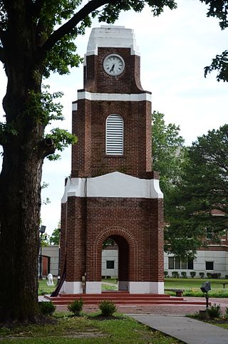
The W.E. O'Bryant Bell Tower occupies a prominent central position on the campus of the University of Arkansas at Pine Bluff in Pine Bluff, Arkansas. It is a three-stage brick structure, with open arches at the base where a fountain once stood. The second stage houses a belfry, and the third a clock. The corners are buttressed, and the levels divided by bands of concrete. The tower was built in 1943–47.

The Pine Bluff Confederate Monument has long been located in front of the Jefferson County courthouse, at Barraque and Main Streets in Pine Bluff, Arkansas. It depicts a standing Confederate Army soldier, holding a rifle whose butt rests on the ground. The statue, built out of Georgia marble by the McNeel Marble Company, stands on a stone base 15 feet (4.6 m) in height and 10 by 10 feet at the base. It was placed in 1910 by the local chapter of the United Daughters of the Confederacy.

The Pine Bluff Commercial Historic District encompasses a portion of the historic city center of Pine Bluff, Arkansas. It extends from Barraque Street south along Main Street, extending in places to properties alongside streets. The area's commercial development began about 1840, when the courthouse square was laid out at Barraque and Main, and proceeded through the early 20th century. Most of the commercial properties of the district were built between 1880 and 1910, and are reflective architecturally of late 19th-century commercial building styles.


