Remo, British Columbia

Last updated

Remo
Canada British Columbia location map 2.svg
Red pog.svg
Remo
Location of Remo in British Columbia
Coordinates: 54°28′59″N128°43′05″W / 54.48306°N 128.71806°W / 54.48306; -128.71806
CountryCanada
Province British Columbia
Region Skeena
Regional district Kitimat–Stikine
Time zone UTC-8 (PST)
  Summer (DST) UTC-7 (PDT)
Area codes 250, 778, 236, & 672
Highways BC-16 (TCH).svg Hwy 16 (TCH)
Waterways Skeena River

Remo is an unincorporated community in the Skeena region of west central British Columbia. Concentrated on the northwestern shore of the Skeena River and immediately northeast of the Zymagotitz River mouth, no direct link exists to the portion on the southeastern shore. [1] On BC Highway 16, the locality is by road about 10 kilometres (6 mi) southwest of Terrace.

Contents

Railway

During the railway construction, a hospital existed at Bateman's Landing (New Remo). [2] In early October 1910, the eastward advance of the Grand Trunk Pacific Railway (GTP) rail head from Prince Rupert reached Mile 87, the Zymagotitz River. [3]

In 1931, an eastbound passenger train struck a rockslide between Amsbury and Remo, derailing a locomotive and three fish cars. The locomotive crew jumped to safety, but a freighthopper was killed. [4] The next year, a 30-metre (100 ft) long and 4.6-metre (15 ft) deep slide buried the tracks just west of Amsbury station. [5] The 1936 flood, demolished the Canadian National Railway (CN) waiting room and washed away the track ballast, leaving the railway track suspended. [6]

In 1945, a 61-metre (200 ft) long and 7.6-metre (25 ft) deep slide filled a cut west of Amsbury. [7] A few weeks later, a larger slide occurred in a narrow cut at Amsbury. [8]

In 1964, the swollen river began to severely erode the railbed. Working through the night, CN crews dumped rock and other fill alongside the weakened embankment, which saved the community from flooding. [9]

The Amsbury passing track was extended in 1983. [10] The present length is 0.8 kilometres (2,570 ft). [11]

Train Timetables (Regular stop or Flag stop)
Mile1914192019251932193519431950195619601961
[12] [13] [14] [15] [16] [17] [12] [18] [19] [20] [21]
Exstew1688.0FlagFlagFlagFlagFlagBothFlagFlagFlagFlag
Shames1681.0FlagFlagFlagFlagFlagBothFlagFlagFlagFlag
Amsbury a 1672.9FlagFlagFlagFlagFlagBothFlagFlagFlagFlag
Remo1670.3 b FlagFlagFlagFlagFlagFlagFlagFlag
Terrace1663.3Reg.Reg.Reg.Reg.Reg.Reg.Reg.Reg.Reg.Reg.
Dobies1659.0 c FlagFlagFlagFlagFlagFlagFlag
Vanarsdol1657.7FlagFlagFlagFlagReg.
Kitselas1657.7FlagFlagFlagFlagFlag

^a . Station initially called Lakelse. [22] The GTP assigned the revised name possibly from its prepared list. [23] Many such names (which were associated with England) had been submitted by Josiah Wedgwood at the request of William P. Hinton, the railway's general manager. [24] Amsbury may well have been a misspelling of Amesbury in the United Kingdom. Another possibility was the premature death in 1910 of Capt. Frederick W. Amsbury. [25]
^b . An unofficial flag stop called Zymacord from at least 1914. [26]
^c . An unofficial flag stop from at least 1918. [27]

Old Remo

About 1908, Harry Clarke (Henry) Breckenridge arrived. [28]

The earliest newspaper mention of Breckenridge Landing is 1910. That year, a road opened to what would become the Terrace area. [29] Breckenridge was the inaugural postmaster 1910–1911, [30] and the post office was at their landing. [31]

In October 1913, the post office name changed from Breckenridge to Remo, which is the earliest newspaper mention of the new name. [32] Apparently, immigrant John Neidhart, postmaster 1912–1920, [30] chose the new name, because he could not pronounce Breckenridge. Allegedly named after his German hometown, no such place seems to exist. The south shore community became known as Old Remo [33] by 1966, the earliest newspaper mention of the present name. [34] However, the label applies to a broad undefined area centred on Alwyn Creek. [35]

New Remo

In 1905, the Bateman family pre-empted their land. [2] While continuing to clear the property in 1907, James E. Bateman was joined by his family. In 1909, Charles Lindstrom married James' daughter Emma. The couple bought part of the pre-emption and built at the Zymagotitz mouth. [31] A trail up that river branched northward at the fork. [26]

In 1917, the Kitsumkallum Timber Co built a sawmill at the river mouth and logged Zimacord Flats up the river. [36]

In 1920, the post office relocated from the south shore of the Skeena to the north one. [30]

In 1931–32, the school opened. [37] The Kitsumkallum Timber mill operated until the later 1930s. [38]

In 1942, the school closed. [39] The November 1945 flood washed out the Zymagotitz River bridge and the approaches to the Shames River bridge, tilting the latter. [40] At the time, most bridges in the Remo district were built on mudsills and floated off with each high water. [41]

In 1960, the post office closed. [30] The earliest newspaper reference to the present name of New Remo is 1966. [42]

The current passenger transit provider is BC Transit. [43]

Steamboats and ferries

Steamboats stopped for cordwood fuel at both Breckenridge Landing [44] and Bateman's Landing. [31]

In 1913, a ferry existed at the mouth of the Lakelse River. [45] That year, the subsidised seasonal ferry across the Skeena commenced. [46] [47]

In 1925, the surplus Terrace ferry was rebuilt and installed at Remo. [48]

In June 1931, the ferry landing buildings were flooded. [49] In the October 1935 floods, the main cable broke, and the reaction ferry was carried downriver, before beaching upon an island below Shames. [50]

In May/June 1936, when the water rose above the 1920 mark, only one house was saved. The remainder, including the ferry house, drifted away. [6] The main tower on the south side was undermined and had to be moved back. The basket tower on the north side needed straightening. Extensive riverbank and roadway were washed out. [51]

In 1937 a new 4.5-tonne; 4.5-long-ton (5-short-ton) pontoon reaction ferry replaced the one destroyed in the 1936 flood. [52]

In 1949, the ferry was discontinued. [46]

Other significant floods

In October 1974, logjams on the Zymagotitz caused severe flooding in New Remo. [53]

In June 1990, the Skeena River spilled its banks, causing the evacuation of between 50 and 100 people in the Old Remo area and minor damage to about 30 homes. [54]

In June 2002, about a dozen people left their homes in the Old Remo area, when several homes were surrounded by water. [55]

Old Remo and New Remo continue to experience flood evacuation alerts. In addition to 2002, Old Remo was flooded in 2007 and 2017. [56]

Agriculture

The Old Remo and New Remo floodplains comprise silty loams, [57] which provide productive land for the several farms. [58] The former encompasses 288 hectares (712 acres) and the latter 126 hectares (311 acres). [59]

Number of properties in 2013 [60] with:
fruit
trees
green-
houses
large
gardens
large
fields
cattle
(herd)
horses
(herd)
Old Remo  32   14    22   224 (20)14 (40)
New Remo  30     7    13     62 (12)  4 (12)

Amsbury

Amsbury is a railway point immediately east of Amsbury Creek. [61] [62]

The seasonal post office operated 1918 and 1919–1923. [63]

Lakelse Lumber Co sawmill, which operated from the late 1910s [64] until the mid-1920s, had a 7,600-metre (25,000 ft) daily capacity. [65]

Maps

See also

Footnotes

  1. "Remo (community)". BC Geographical Names .
  2. 1 2 "Bateman's Landing". www.gent.name.
  3. "Prince Rupert Optimist". library.ubc.ca. 6 Oct 1910. p. 1.
  4. Septer 2007, p. 21.
  5. Septer 2007, p. 24.
  6. 1 2 Septer 2007, p. 33.
  7. Septer 2007, p. 42.
  8. Septer 2007, p. 43.
  9. Septer 2007, p. 87.
  10. "Prince George Citizen". pgnewspapers.pgpl.ca. 24 Mar 1983. p. 22.
  11. "CN Skeena Subdivision" (PDF). www.cwrailway.ca.
  12. 1 2 "Timetable" (PDF). streamlinermemories.info. 28 Apr 1943. p. 62 (TT226).
  13. Timetable. 1 Mar 1914. p. 15 (TT14).
  14. Timetable. 3 Oct 1920. p. 12.
  15. Timetable. Jan 1925. p.106 (TT156)
  16. Timetable. 1932. p.58 (TT226)
  17. Timetable. 1935. p.60 (TT226)
  18. "Timetable". www.scribd.com. 30 Apr 1950. p. 59 (TT226).
  19. "Timetable" (PDF). streamlinermemories.info. 30 Sep 1956. p. 55 (TT138).
  20. "Timetable" (PDF). streamlinermemories.info. 30 Oct 1960. p. 54 (TT139).
  21. "Timetable". pre.timetableworld.com. 30 Apr 1961. p. 39 (TT58).
  22. "Daily News (Prince Rupert)". library.ubc.ca. 9 Aug 1911. p. 1.
  23. "Prince George Citizen". pgnewspapers.pgpl.ca. 27 Jan 1984. p. 44.
  24. "Prince George Citizen". pgnewspapers.pgpl.ca. 27 May 1957. p. 19.
  25. "Prince Rupert Journal". library.ubc.ca. 6 Sep 1910. p. 4.
  26. 1 2 Minister of Lands annual report, 1914. library.ubc.ca (Report). p. 189 (D180).
  27. "1918 BC Directory". www.bccd.vpl.ca.
  28. 1 2 "Remo". www.gent.name.
  29. "Prince Rupert Optimist". library.ubc.ca. 27 Sep 1910. p. 8.
  30. 1 2 3 4 "Postmasters (Remo)". www.bac-lac.gc.ca.
  31. 1 2 3 Asante 1972, p. 132.
  32. "Review". library.ubc.ca. 30 Oct 1913. p. 4.
  33. "Daily Herald (Terrace)" (PDF). core.ac.uk. 16 Jul 1980. p. 7.
  34. "Terrace Herald" (PDF). core.ac.uk. 27 Jul 1966. p. 1.
  35. "Old Remo (locality)". BC Geographical Names .
  36. Asante 1972, p. 23.
  37. Public Schools annual report, 1931–32. library.ubc.ca (Report). p. L10.
  38. "1937 BC Directory". www.bccd.vpl.ca.
  39. Public Schools annual report, 1941–42. library.ubc.ca (Report). p. 229 (B221).
  40. Septer 2007, p. 45.
  41. Septer 2007, p. 37.
  42. "Terrace Herald" (PDF). core.ac.uk. 9 Nov 1966. p. 16.
  43. "Route 13: Kitsumkalum". www.bctransit.com.
  44. "Prince Rupert Optimist". library.ubc.ca. 7 Dec 1910. p. 3.
  45. Minister of Lands annual report, 1913. library.ubc.ca (Report). p. 426 (D361).
  46. 1 2 Clapp, Frank A. (1991). Ministry of Transportation and Highways, Lake and River Ferries. Ministry of Transportation and Highways. p. 18. ISBN   0-7726-1364-8.
  47. Minister of Public Works annual report, 1912–13. library.ubc.ca (Report). p. S79.
  48. Minister of Public Works annual report, 1925–26. library.ubc.ca (Report). p. 34 (Q22).
  49. Septer 2007, p. 22.
  50. Septer 2007, p. 30.
  51. Septer 2007, p. 34.
  52. Minister of Public Works annual report, 1937–38. library.ubc.ca (Report). p. 30 (X26).
  53. Septer 2007, p. 120.
  54. Septer 2007, p. 163.
  55. Septer 2007, p. 191.
  56. "Weather Network". www.theweathernetwork.com. 16 May 2023.
  57. Gagné & Kerby 2013, p. 31 (30).
  58. Gagné & Kerby 2013, p. 32 (31).
  59. Gagné & Kerby 2013, p. 33 (32).
  60. Gagné & Kerby 2013, p. 36 (35).
  61. "Amsbury (railway point)". BC Geographical Names .
  62. "Amsbury creek (creek)". BC Geographical Names .
  63. "Postmasters (Amsbury)". www.bac-lac.gc.ca.
  64. "Amsbury". www.gent.name.
  65. "Prince George Citizen". pgnewspapers.pgpl.ca. 3 Jun 1923. p. 3.

Related Research Articles

British Columbia Ferry Services Inc., operating as BC Ferries (BCF), is a former provincial Crown corporation, now operating as an independently managed, publicly owned Canadian company. BC Ferries provides all major passenger and vehicle ferry services for coastal and island communities in the Canadian province of British Columbia. Set up in 1960 to provide a similar service to that provided by the Black Ball Line and the Canadian Pacific Railway, which were affected by job action at the time, BC Ferries has become the largest passenger ferry line in North America, operating a fleet of 41 vessels with a total passenger and crew capacity of over 27,000, serving 47 locations on the B.C. coast.

Highway 16 is a highway in British Columbia, Canada. It is an important section of the Yellowhead Highway, a part of the Trans-Canada Highway that runs across Western Canada. The highway closely follows the path of the northern B.C. alignment of the Canadian National Railway (CN). The number "16" was first given to the highway in 1941, and originally, the route that the highway took was more to the north of today's highway, and it was not as long as it is now. Highway 16 originally ran from New Hazelton east to Aleza Lake. In 1947, Highway 16's western end was moved from New Hazelton to the coastal city of Prince Rupert, and in 1953, the highway was re-aligned to end at Prince George. In 1969, further alignment east into Yellowhead Pass was opened to traffic after being constructed up through 1968 and raised to all-weather standards in 1969. Highway 16's alignment on Haida Gwaii was commissioned in 1983 and is connected to the mainland segment via BC Ferries route #11.

<span class="mw-page-title-main">Terrace, British Columbia</span> City in British Columbia, Canada

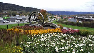
Terrace is a city in the Skeena region of west central British Columbia, Canada. This regional hub lies east of the confluence of the Kitsumkalum River into the Skeena River. On BC Highway 16, junctions branch northward for the Nisga'a Highway to the west and southward for the Stewart–Cassiar Highway to the east. The locality is by road about 204 kilometres (127 mi) southwest of Smithers and 144 kilometres (89 mi) east of Prince Rupert. Transportation links are the Northwest Regional Airport, a passenger train, and bus services.

<span class="mw-page-title-main">Hazelton, British Columbia</span> Village municipality in British Columbia, Canada

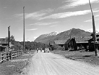
Hazelton is a village municipality in the Skeena region of west central British Columbia, Canada. The place is on the southeast side of the Skeena River immediately north of the Bulkley River mouth, where the confluence forms a peninsula. On BC Highway 62, the locality is by road about 75 kilometres (47 mi) northwest of Smithers and 144 kilometres (89 mi) northeast of Terrace. Hazelton is the original of the "Three Hazeltons", the other two being New Hazelton to the southeast and South Hazelton to the south.

<span class="mw-page-title-main">Usk, British Columbia</span> Hamlet in British Columbia, Canada

Usk is an unincorporated community in the Skeena region of west central British Columbia, Canada. The Usk Ferry connects the two parts of the hamlet that straddle the Skeena River. Just off BC Highway 16, the locality is by road about 182 kilometres (113 mi) west of Smithers and 23 kilometres (14 mi) northeast of Terrace.

<span class="mw-page-title-main">Seton Lake</span> Lake in British Columbia, Canada

Seton Lake is a lake in the Squamish-Lillooet region of southwestern British Columbia. On the northeast side is Mission Ridge. On the southwest is the Cayoosh Range. By road, the eastern end is about 7 kilometres (4.3 mi) southwest of Lillooet.

<span class="mw-page-title-main">Alexandra Bridge Provincial Park</span> Provincial park in British Columbia, Canada

Alexandra Bridge Park lies within the lower Fraser Canyon of British Columbia, Canada. This provincial park is adjacent to the historic suspension bridge from 1926, which spans the Fraser River and was built using the eastern abutment of the bridge from 1863. The locality, on BC Highway 1, is by road about 44 kilometres (27 mi) north of Hope and 65 kilometres (40 mi) south of Lytton.

<span class="mw-page-title-main">Gitsegukla</span> Community in British Columbia, Canada

Gitsegukla is an unincorporated community in the Skeena region of west central British Columbia, Canada. The place is on the southeast side of the Skeena River adjacent to the Kitseguecla River mouth. On BC Highway 16, the locality is by road about 94 kilometres (58 mi) northwest of Smithers and 113 kilometres (70 mi) northeast of Terrace.

<span class="mw-page-title-main">Kitwanga</span> Place in British Columbia, Canada

Kitwanga or Gitwangak is in the Skeena region of west central British Columbia. Among the Hazelton and Buckley Mountain Ranges, the place is on the north shore of the Skeena River, east of the Kitwanga River confluence. On BC Highway 37, northeast of the junction with BC Highway 16, the locality is by road about 115 kilometres (71 mi) northwest of Smithers, 99 kilometres (62 mi) northeast of Terrace, and 212 kilometres (132 mi) southeast of Stewart.

Alexandria or Fort Alexandria was a general area encompassing a trading post, ferry site, and steamboat landing in the North Cariboo region of central British Columbia. The present unincorporated community is on the eastern side of the Fraser River. On BC Highway 97, the locality is by road about 74 kilometres (46 mi) northwest of Williams Lake and 45 kilometres (28 mi) south of Quesnel.

<span class="mw-page-title-main">Kitselas Canyon</span> Canyon in Kitimat-Stikine Regional District, Canada

Kitselas Canyon is a canyon carved by the Skeena River in the Skeena region of west central British Columbia, Canada. Off BC Highway 16, the landmark is by road about 185 kilometres (115 mi) west of Smithers and 20 kilometres (12 mi) northeast of Terrace.

Kitselas is a railway point on the northwestern shore of the Skeena River in the Skeena region of west central British Columbia, Canada. The former name was Vanarsdol. Across the Skeena to the southwest is the mouth of the Zymoetz River. This river bridge on BC Highway 16 is by road about 10 kilometres (6 mi) northeast of Terrace.

Cedarvale or Meanskinisht is an unincorporated community in the Skeena region of west central British Columbia. Concentrated on the southeastern shore of the Skeena River, no direct link exists to the portion on the northwestern shore. On BC Highway 16, the locality is by road about 130 kilometres (81 mi) northwest of Smithers and 75 kilometres (47 mi) northeast of Terrace.

The Usk Ferry operates on the Skeena River at Usk in the Skeena region of west central British Columbia, Canada. The vessel employs reaction ferry propulsion and cable ferry guidance. Off BC Highway 16, the crossing is by road about 182 kilometres (113 mi) west of Smithers and 23 kilometres (14 mi) northeast of Terrace.

<span class="mw-page-title-main">Hyder–Stewart Border Crossing</span>

The Hyder–Stewart Border Crossing connects the communities of Hyder, Alaska, and Stewart, British Columbia, on the Canada–United States border. International Street on the American side joins British Columbia Highway 37A on the Canadian side.

South Hazelton is an unincorporated community in the Skeena region of west central British Columbia, Canada. The place is on the east side of the Skeena River immediately south of the Bulkley River mouth. On BC Highway 16, the locality is by road about 73 kilometres (45 mi) northwest of Smithers and 132 kilometres (82 mi) northeast of Terrace. South Hazelton is one of the "Three Hazeltons", the other two being the original "Old" Hazelton to the north and New Hazelton to the east.

Pacific is a railway point in the Skeena region of west central British Columbia. On the western shore of the Skeena River, no direct link exists to the highway section on the eastern shore near the mouth of Legate Creek. On BC Highway 16, the locality is by road about 164 kilometres (102 mi) west of Smithers and 40 kilometres (25 mi) northeast of Terrace.

Isle Pierre is a railway point in the Nechako Region of central British Columbia. The scattered community straddles the shores of the Nechako River. The west side, off BC Highway 16, is by road about 55 kilometres (34 mi) west of Prince George and 69 kilometres (43 mi) east of Vanderhoof. The east side is by road about 46 kilometres (29 mi) west of Prince George.

Miworth is an unincorporated community on the southeast shore of the Nechako River in the Nechako Region of central British Columbia. The location, via Otway Rd and Miworth Rd, is about 16 kilometres (10 mi) northwest of Prince George.

<span class="mw-page-title-main">Anderson Flats Provincial Park</span> Provincial Park in British Columbia, Canada

Anderson Flats Park is in the Skeena region of west central British Columbia, Canada. This provincial park is on the southeast shore at the junction of the Skeena River and Buckley River, between South Hazelton and "Old" Hazelton. Off BC Highway 16, the locality is by road about 73 kilometres (45 mi) northwest of Smithers and 132 kilometres (82 mi) northeast of Terrace.

References