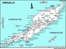

Rendezvous Bay Pond, also known as Rendezvous Bay Salt Pond, is a wetland in Anguilla, a British Overseas Territory in the Caribbean Sea. It is one of the territory's Important Bird Areas (IBAs).
Rendezvous Bay Pond, also known as Rendezvous Bay Salt Pond, is a wetland in Anguilla, a British Overseas Territory in the Caribbean Sea. It is one of the territory's Important Bird Areas (IBAs).

The pond is a shallow, 24 ha brackish lagoon near the south-western end of the main island. The substrate is marl on the northern side and sand on the southern. It receives fresh water from rainfall, runoff and a few springs. The pond also receives salt water seepage from the bay through the strip of beach that divides them. It was historically used for salt production. Vegetation around the pond is sparse, except for stands of buttonwood mangroves at its western end. Land at the eastern end is mainly used for livestock grazing. [1]
The IBA was identified as such by BirdLife International because it supports a small breeding colony of least terns as well as populations of common terns and brown pelicans. [1]
Lake Macleod is a marine salt lake in the Gascoyne region of Western Australia, 30 kilometres (19 mi) north of the port and regional centre of Carnarvon.

The Swan Bay is a shallow, 30-square-kilometre (12 sq mi) marine embayment at the eastern end of the Bellarine Peninsula in Port Phillip, Victoria, Australia. The township of Queenscliff lies at its southern end, and St Leonards at its northern. It is partly separated from Port Phillip by Swan Island, Duck Island and Edwards Point. Most of the area is included in the Port Phillip Heads Marine National Park as well as being listed as a wetland of international importance under the Ramsar Convention as part of the Port Phillip Bay and Bellarine Peninsula Ramsar Site. The bay is part of the Swan Bay and Port Phillip Bay Islands Important Bird Area, identified as such by BirdLife International because of its importance for orange-bellied parrots, waders and seabirds.

Exmouth Gulf is a gulf in the north-west of Western Australia. It lies between North West Cape and the main coastline of Western Australia. It is considered to be part of the Pilbara Coast and Northwest Shelf, and the Carnarvon Basin geologic formation. It was named after Edward Pellew, 1st Viscount Exmouth by Phillip Parker King in 1818.
Great Pond is a 50 ha saline coastal lagoon on the south-eastern shoreline of the island of Saint Croix in the United States Virgin Islands. The pond is part of St Croix East End Marine Park. It the second largest salt pond in the Virgin Islands, and is one of the largest remaining mangrove tracts in St. Croix.

Limmen Bight is a bight, or large, open bay, located in the Northern Territory of Australia at the western end of the Gulf of Carpentaria about 360 kilometres (220 mi) east of the town of Katherine. It is part of the traditional lands and waters of the Marra people. It was named in April 1644 by Abel Tasman for one of his ships on his voyage of exploration along the northern Australian coast. It contains the second largest area of tidal flats in the Northern Territory.

Cove Pond is a shallow 287 ha wetland at the south-western end of the Caribbean island of Anguilla, a British Overseas Territory. It forms part of a larger coastal lagoon from which it is separated by a causeway constructed for access to the Cap Juluca resort.
Long Pond, also known as Long Salt Pond, is a 23 ha brackish lagoon on the central south-eastern coast of the main island of Anguilla, a British Overseas Territory in the Caribbean. About 1.2 km long, it is separated from the sea at its eastern end by sand dunes. Its south shore is separated from the sea by a 300 m wide strip of scrub vegetation on limestone. The area to the north and west is residential.
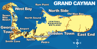
The Central Manrove Wetland is a large area of mangrove dominated wetland on Grand Cayman, one of the Cayman Islands, a British Overseas Territory in the Caribbean Sea. It is one of the territory's Important Bird Areas (IBAs).

The Crown Wetlands lie on Little Cayman, one of the Cayman Islands, a British Overseas Territory in the Caribbean Sea. Collectively they form one of the territory's Important Bird Areas (IBAs).
Road Salt Pond, also known as Road Bay Pond or simply Road Pond, is a wetland in Anguilla, a British Overseas Territory in the Caribbean Sea. It is one of the territory's Important Bird Areas (IBAs).
Cauls Pond is a wetland in Anguilla, a British Overseas Territory in the Caribbean Sea. It is one of the territory's Important Bird Areas (IBAs).
West End Pond is a wetland in Anguilla, a British Overseas Territory in the Caribbean Sea. It is one of the territory's Important Bird Areas (IBAs).
Meads Bay Pond is a wetland in Anguilla, a British Overseas Territory in the Caribbean Sea. It is one of the territory's Important Bird Areas (IBAs).
The Merrywing Pond System is a golf course wetland system in Anguilla, a British Overseas Territory in the Caribbean Sea. It forms one of the territory's Important Bird Areas (IBAs).
Forest Bay Pond is a small wetland in Anguilla, a British Overseas Territory in the Caribbean Sea. It forms one of the territory's Important Bird Areas (IBAs).

The Fish Ponds and Crossing Place Trail Important Bird Area is a 1024 ha tract of land on the island of Middle Caicos in the Turks and Caicos Islands, a British Overseas Territory in the Lucayan Archipelago of the western Atlantic Ocean. It forms one of the territory's Important Bird Areas (IBAs).
Saba Island is a rocky Caribbean island in the United States Virgin Islands, situated three miles south of Cyril E. King Airport on St. Thomas and 2.6 miles west of Water Island. It is a steep, 200 feet high island with a sandy beach on the northern side. Turtledove Cay is connected by a shallow sandbar. Saba Island has salt ponds on both the eastern and western sides, which is popular bird observation posts, and has numerous rocky cliffs with sea birds on its southern shores. Besides for bird observation, the island is visited by scuba divers and snorkelers. In addition to coral reefs, the waters here are home to numerous ship wrecks, such as the Witshoal II, Witconcrete II, Grainton, and Witservice IV.

The San Francisco Bay Salt Ponds are a roughly 16,500-acre (6,700 ha) part of the San Francisco Bay that have been used as salt evaporation ponds since the California Gold Rush era. Most of the ponds were once wetlands in the cities of Redwood City, Newark, and Hayward, and other parts of the bay.

The Ryder Bay Islands Important Bird Area is a 520 ha designated site on the south-east coast of Adelaide Island, Antarctica. It has been identified as an Important Bird Area (IBA) by BirdLife International because it supports significant numbers of breeding seabirds, notably south polar skuas. The site encompasses the Léonie Islands lying at the mouth of Ryder Bay, as well as Rothera Point, the eastern headland of the bay.
18°10′31″N63°06′20″W / 18.17528°N 63.10556°W
| | This Anguilla location article is a stub. You can help Wikipedia by expanding it. |