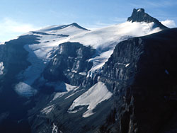
Resolute Mountain | |
---|---|
Lion Peak | |
Highest point | |
Elevation | 3,150 m (10,330 ft) [1] [2] |
Prominence | 395 m (1,296 ft) [3] |
Parent peak | Mount Cline (3361 m) [4] |
Listing | Mountains of Alberta |
Coordinates | 52°04′24″N116°39′34″W / 52.07333°N 116.65944°W [5] |
Geography | |
Country | Canada |
Province | Alberta |
Parent range | Cline Range [6] |
Topo map | NTS 83C2 Cline River [5] |
Climbing | |
First ascent | 1958 A. Hober, E. Hopkins, D.G. Linke [4] |
Resolute Mountain is located in David Thompson Country, western Alberta, Canada, 12 km north of Saskatchewan River Crossing. Its line parent is Mount Cline located 2 kilometres to the east. [7] [3]
Resolute has two main peaks, Lion and Lioness. They are each about 3150 m high. Both peaks are glaciated on their northern slopes. [1] Resolute was first ascended in 1958 by A. Hober and E. Hopkins. The easiest route up Resolute is accessible from Alberta Highway 11, where it crosses Thompson creek. [8]
Mount Forbes is the seventh tallest mountain in the Canadian Rockies and the tallest within the boundaries of Banff National Park. It is located in southwestern Alberta, 18 km (11 mi) southwest of the Saskatchewan River Crossing in Banff. The mountain was named by James Hector in 1859 after Edward Forbes, Hector's natural history professor at the University of Edinburgh during the mid-19th century.
Rocky Mountain House is a town in west-central Alberta, Canada. It is approximately 77 km (48 mi) west of Red Deer at the confluence of the Clearwater and North Saskatchewan Rivers, and at the crossroads of Highway 22 and Highway 11. The surrounding Clearwater County's administration office is located in Rocky Mountain House.
Mount Saskatchewan is a mountain located in the North Saskatchewan River valley of Banff National Park, in the Canadian Rockies of Alberta, Canada.
Mount Hector is a 3,394-metre (11,135-foot) mountain summit located in the Bow River valley of Banff National Park, in the Canadian Rockies of Alberta, Canada. The mountain was named in 1884 by George M. Dawson after James Hector, a geologist on the Palliser expedition. The mountain is located beside the Icefields Parkway, 17 km (11 mi) north of Lake Louise.
Howse Peak is the highest mountain in the Waputik Mountains, a subrange of the Canadian Rockies. It is located 5 km (3 mi) west of the Icefields Parkway, above Chephren Lake, on the continental divide between Alberta and British Columbia. At 3,295 m (10,810 ft), it is the 46th highest peak in Alberta, and the 59th highest in British Columbia.
Abraham Lake, also known as Lake Abraham, is an artificial lake and Alberta's largest reservoir. It is located in the "Kootenay Plains area of the Canadian Rockies' front range", on the North Saskatchewan River in western Alberta, Canada.
Mount Balfour is a mountain located on the Continental Divide, part of the border between British Columbia and Alberta, in the Waputik Range in the Park Ranges of the Canadian Rockies. It is the 71st highest peak in Alberta and the 113th highest in British Columbia; it is also the 52nd most prominent in Alberta.
Mount Cline is a mountain in western Alberta, Canada, 11 km (7 mi) north of Saskatchewan Crossing, 60 km (37 mi) southwest of Nordegg.
Cline River is a locality in central Alberta, Canada within Clearwater County. It is located along Highway 11 approximately 134 km (83 mi) west of Rocky Mountain House.
Elliott Peak is a 2,873-metre (9,426 ft) mountain summit located in the North Saskatchewan River valley of the Canadian Rockies of Alberta, Canada. Its nearest higher peak is Mount Cline, 16.0 km (9.9 mi) to the southwest. Elliott Peak can be seen from David Thompson Highway and Abraham Lake. Precipitation runoff from Elliott Peak drains into tributaries of the Saskatchewan River. Mount Ernest Ross is located immediately south of the mountain.
Coliseum Mountain is a peak north of the town of Nordegg, Alberta, Canada. It is in the David Thompson Country of the Canadian Rockies. It has a summit of 2,035 m (6677 ft). The mountain was named after its amphitheatre bowl shape resembling the Colosseum of ancient Rome. The Stoney First Nations previously named the peak Yahareskin, meaning "mountain with a cap" because of its bare summit.
Mount Wilson is a 3,260-metre (10,696 ft) mountain summit located in the North Saskatchewan River valley of Banff National Park, in the Canadian Rockies of Alberta, Canada. Its nearest higher peak is Mount Cline, 9.81 km (6.10 mi) to the northeast. Mount Wilson is situated immediately north of the confluence of the North Saskatchewan River, Mistaya River, and Howse River near Saskatchewan Crossing, where the Icefields Parkway intersects with the David Thompson Highway.
Mount Murchison is a 3,348-metre (10,984 ft) mountain summit located at the convergence of the North Saskatchewan River valley and Mistaya River valley of Banff National Park, in the Canadian Rockies of Alberta, Canada. The main summit has two high points: the Southeast Peak is 3,348 m, whereas the Northwest Peak is 3,333 m and separated by 700 m distance. Its nearest higher peak is Mount Cline, 15.71 km (9.76 mi) to the north. Mount Murchison is situated immediately southeast of the confluence of the North Saskatchewan River, Mistaya River, and Howse River near Saskatchewan Crossing, where the Icefields Parkway intersects with the David Thompson Highway.
Mount Thompson is a 3,089-metre (10,135-foot) mountain summit located four kilometres west of Bow Lake in Banff National Park, in the Canadian Rockies of Alberta, Canada. Its nearest higher peak is Mount Baker, 5.0 km (3.1 mi) to the west. Mount Thompson is situated east of the Wapta Icefield, and is a member of the Waputik Mountains. Mount Thompson can be seen from the Icefields Parkway at Bow Lake.
Mount McGillivray is a 2,451-metre (8,041-foot) mountain summit located in the Bow Valley of Kananaskis Country in the Canadian Rockies of Alberta, Canada. Its nearest higher peak is Skogan Peak, 3.0 km (1.9 mi) to the southeast. Mount McGillivray is a landmark that can be seen from Highway 1, the Trans-Canada Highway in the Exshaw area.
Abraham Mountain is a 2,820-metre (9,250-foot) mountain summit located in the North Saskatchewan River valley of the Canadian Rockies of Alberta, Canada. Its nearest higher peak is Allstones Peak, 2.0 km (1.2 mi) to the west. Abraham Mountain can be seen from David Thompson Highway and Abraham Lake. Precipitation runoff from Abraham Mountain drains east into Abraham Lake.
Siffleur Mountain is a 3,129-metre (10,266 ft) mountain summit located in the North Saskatchewan River valley of Alberta, Canada. Siffleur Mountain is situated in the Siffleur Wilderness Area of the Canadian Rockies. Its nearest higher peak is Mount Loudon, 3 km (1.9 mi) to the southwest. The mountain can be seen from Highway 11, the David Thompson Highway. Precipitation runoff from Siffleur Mountain flows north via Loudon Creek and Siffleur River.
Mount Peskett is a 3,124-metre (10,249-foot) mountain summit located in the North Saskatchewan River valley of Alberta, Canada. Mount Peskett is situated in the Canadian Rockies on the northern boundary the Siffleur Wilderness Area. Its nearest higher peaks are Mount Loudon, 3.7 km (2.3 mi) to the south, and Siffleur Mountain 3.7 km to the southeast. Mount Peskett can be seen from Highway 11, the David Thompson Highway. Precipitation runoff from the mountain flows north via Loudon Creek and Spreading Creek which are both tributaries of the North Saskatchewan River.
Mount Ernest Ross is a 2,454-metre (8,051-foot) double summit mountain located in the North Saskatchewan River valley of the Canadian Rockies of Alberta, Canada. Mount Ernest Ross can be seen from the David Thompson Highway at the southern end of Abraham Lake. Precipitation runoff from the peak drains east into the lake. Mount William Booth is across the lake to the east, and Kootenay Plains and Ex Coelis Mountain are situated to the southeast. Its nearest higher peak is Elliott Peak, 3 km (1.9 mi) to the immediate north.
Mount Loudon is a 3,221-metre (10,568 ft) mountain summit located in the North Saskatchewan River valley of Alberta, Canada. Mount Loudon is situated in the Siffleur Wilderness Area of the Canadian Rockies. Its nearest higher peak is Mount Murchison, 15 km (9.3 mi) to the west. Siffleur Mountain is located immediately northeast, and Mount Peskett immediately north. Mount Loudon can be seen from Highway 11, the David Thompson Highway. Precipitation runoff from the mountain flows north via Loudon Creek and Porcupine Creek, which are both tributaries of the North Saskatchewan River.