History
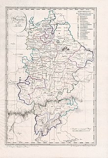
In the years between 1806 and 1808, the Kingdom of Bavaria was divided into 15 (administrative) districts, whose names were taken from the local rivers. The Rezatkreis was bordered in the north by the Bavarian Mainkreis (Obermainkreis after 1817), in the east by the Pegnitzkreis and the Altmühlkreis (until 1810), in the south by the Bavarian Oberdonaukreis and in the west by the Württemberger Jagstkreis. In 1817, the number of districts was reduced from eight to seven (with the Rheinpfalz). The Pegnitzkreis and the northern part of the former Altmühlkreis (which had belonged since 1810 to the Oberdonaukreis) were added to the Rezatkreis. Anspach was the district capital [Kreisstadt]. At the request of King Ludwig I, the Territorial Reorganization (Gebietsreform) was made on 29 November 1837. Consequently, on 1 January 1838, the Rezatkreis became Mittelfranken [Upper Franconia], one of the seven current Regierungsbezirke of the Kingdom and later State of Bavaria.

Bavaria, officially the Free State of Bavaria, is a landlocked federal state of Germany, occupying its southeastern corner. With an area of 70,550.19 square kilometres, Bavaria is the largest German state by land area comprising roughly a fifth of the total land area of Germany. With 13 million inhabitants, it is Germany's second-most-populous state after North Rhine-Westphalia. Bavaria's main cities are Munich and Nuremberg.

Franconia is a region in Germany, characterised by its culture and language, and may be roughly associated with the areas in which the East Franconian dialect group, colloquially referred to as "Franconian", is spoken. There are several other Franconian dialects, but only the East Franconian ones are colloquially referred to as "Franconian".

Swabia is one of the seven administrative regions of Bavaria, Germany.

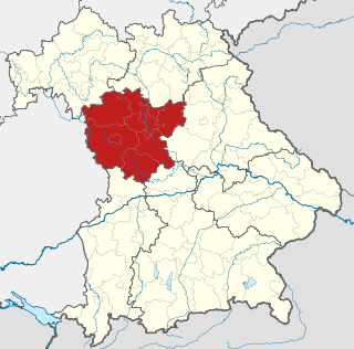
Upper Franconia is a Regierungsbezirk of the state of Bavaria, southern Germany. It forms part of the historically significant region of Franconia, all now part of the German Federal State of Bayern (Bavaria).

The Upper Palatinate is one of the seven administrative districts of Bavaria, Germany, located in the east of Bavaria.

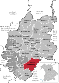
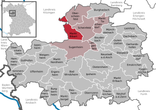
Neustadt an der Aisch is a small town of around 12,000 in the northern part of Bavaria (Germany), within the Franconian administrative region Middle Franconia.
It is the district town of the district Neustadt (Aisch)-Bad Windsheim.

Neuburg an der Donau, literally Newcastle on the river Danube, is a town which is the capital of the Neuburg-Schrobenhausen district in the state of Bavaria in Germany.

The Rednitz is a 46 km (29 mi) long river in Franconia, Germany, tributary of the Regnitz. The Rednitz is formed by the confluence of the rivers Franconian Rezat and Swabian Rezat, in Georgensgmünd. The Rednitz flows north through Roth bei Nürnberg, Schwabach and the southwestern quarters of Nuremberg. The Rednitz joins the Pegnitz to form the Regnitz in Fürth.

The coat of arms of Bavaria has greater and lesser versions.

Hoheneck Castle is a medieval castle above Ipsheim and also a district of the municipality of Ipsheim in the Landkreis Neustadt (Aisch)-Bad Windsheim in Middle Franconia in Bavaria, Germany. Since 1984, the youth castle serves as an educational institution of the Youth Council of the city of Nuremberg.
The Mainkreis was one of the 15 administrative districts of the Kingdom of Bavaria between 1806 and 1837 named after its main river Main. It was the predecessor of the Regierungsbezirk Oberfranken.
The Regenkreis, with Straubing and later Regensburg as its capital, existed between 1806 and 1837 as one of the 15 districts of the Kingdom of Bavaria. Between 1806 and 1808, the Kingdom of Bavaria was divided into 15 (state) districts named after rivers. In English, Regenkreis means “District of Regen” and was named after the Regen River which flowed through the district. Regenkreis was the predecessor of the Regierungsbezirks Oberpfalz.
The Isarkreis was one of the 15 administrative districts of the Kingdom of Bavaria between 1806 and 1837. It is named after it's main river, the Isar. It was the predecessor of the Regierungsbezirk Oberbayern.
The Oberdonaukreis was one of the 15 administrative districts of the Kingdom of Bavaria between 1806 and 1837 named after its main river Danube. It was the predecessor of the Regierungsbezirk Schwaben.
The Lower Danube Circle or Under Danube Circle was one of the administrative districts of the Kingdom of Bavaria between 1806 and 1837. It was named after its main river, the Danube and was the predecessor of the administrative district of Lower Bavaria. Its administrative headquarters were in Passau, but the appelate court was in Straubing.
The Untermainkreis was one of the administrative districts of the Kingdom of Bavaria between 1806 and 1837 named after its main river Main. It was the predecessor of the administrative district of Lower Franconia. Administrative headquarters were in Würzburg.

Franconia is a region that is not precisely defined, but which lies in the north of the Free State of Bavaria, parts of Baden-Württemberg and South Thuringia and Hesse in Germany. It is characterised by its own cultural and linguistic heritage. Its history began with the first recorded human settlement about 600,000 years ago. Thuringii, Alemanni and Franks, who gave the region its name, settled the area in the Early Middle Ages. From the mid-9th century, the Stem Duchy of Franconia emerged as one of the five stem duchies of the Empire of East Francia. On 2 July 1500, during the reign of Emperor Maximilian I, as part of the Imperial Reform, the empire was divided into Imperial Circles. The Franconian Circle, which was formed as a result of this restructuring, became decisive in the creation of a Franconian national identity. A feature of Franconia in the Middle Ages and Early Modern Period was its Kleinstaaterei, an extreme fragmentation into little states and territories. In the 19th century under Napoleon, large parts of Franconia were incorporated into the newly created Kingdom of Bavaria.

Thuisbrunn Castle is located centrally within the parish of Thuisbrunn in the municipality of Gräfenberg in the Bavarian province of Upper Franconia. After having been destroyed and rebuilt several times, the castle is now in private ownership.