Heilsbronn

Last updated
Heilsbronn
Heilsbronn, Munster-002.jpg
Church of Saint Mary and Saint James at the Heilsbronn Abbey
Wappen Heilsbronn.svg
Location of Heilsbronn within Ansbach district
Heilsbronn in AN.svgUnterer WaldAdelshofenBruckbergBurkEhingenLichtenauMerkendorfSchopflochWeidenbachWettringenAurach
Germany adm location map.svg
Red pog.svg
Heilsbronn
Bavaria location map.svg
Red pog.svg
Heilsbronn
Coordinates: 49°19′N10°48′E / 49.317°N 10.800°E / 49.317; 10.800
Country Germany
State Bavaria
Admin. region Mittelfranken
District Ansbach
Subdivisions18 Ortsteile
Government
   Mayor (202026) Jürgen Pfeiffer [1] (CSU)
Area
  Total62.23 km2 (24.03 sq mi)
Elevation
400 m (1,300 ft)
Population
 (2021-12-31) [2]
  Total9,825
  Density160/km2 (410/sq mi)
Time zone UTC+01:00 (CET)
  Summer (DST) UTC+02:00 (CEST)
Postal codes
91560
Dialling codes 09872
Vehicle registration AN
Website www.heilsbronn.de

Heilsbronn is a town in the Ansbach district of the Mittelfranken administrative region of Franconia, in the German state of Bavaria between Nuremberg and Ansbach, in the wooded valley of the Rangau. Its hallmark is the Katharinenturm, a medieval tower.

Heilsbronn should not be confused with the far larger city of Heilbronn, which lies 130 km further west.

Heilsbronn Abbey

In the Middle Ages it was the seat of one of the great monasteries of Germany, with possessions around Franconia as far as Regensburg and in Württemberg. It was founded in 1132 and continued to exist until 1555. Its sepulchral monuments, many of which are figured by Hocker, Heilsbronnischer Antiquitätenschatz (Ansbach, 1731-1740), are of exceptionally high artistic interest. It was the hereditary burial-place of the Hohenzollern family and ten burgraves of Nuremberg, five margraves and three electors of Brandenburg, and many other persons of note are buried within its walls. [3]

The Monk of Heilsbronn is the ordinary appellation of a didactic poet of the 14th century, whose Sieben Graden, Tochter Syon and Leben des heiligen Alexius were published by J. F. L. T. Merzdorf at Berlin in 1870. [3]

Related Research Articles

<span class="mw-page-title-main">Middle Franconia</span> Regierungsbezirk in Bavaria, Germany

Middle Franconia is one of the three administrative regions of Franconia in Bavaria, Germany. It is located in the west of Bavaria and borders the state of Baden-Württemberg. The administrative seat is Ansbach; however, the most populous city is Nuremberg.

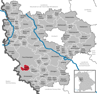
Roth is a Landkreis (district) in Middle Franconia, Bavaria, Germany. It is bounded by the districts of Nürnberger Land, Neumarkt, Eichstätt, Weißenburg-Gunzenhausen, Ansbach and Fürth, and the cities of Schwabach and Nürnberg.

<span class="mw-page-title-main">Weisendorf</span> Municipality in Bavaria, Germany

Weisendorf is a municipality in the district of Erlangen-Höchstadt, in Bavaria, Germany. It belongs to the administrative region of Middle Franconia.

<span class="mw-page-title-main">Roßtal</span> Municipality in Bavaria, Germany

Roßtal is a market town in the district of Fürth, Bavaria, Germany. As of 2020 it had a population of 10,127. It has a primary school and a secondary school. The church is named St. Laurentius and was built from 1025 to 1042.

<span class="mw-page-title-main">Abenberg</span> Town in Bavaria, Germany

Abenberg is a town in the Middle Franconian district of Roth, in Bavaria, Germany. It is situated 9 km west of Roth bei Nürnberg and 25 km southwest of Nuremberg.

<span class="mw-page-title-main">Herrieden</span> Town in Bavaria, Germany

Herrieden is a town in the district of Ansbach and situated in the Middle Franconia region of Bavaria, Germany. It lies along the upper Altmühl river, about 9 km (6 mi) southwest of the city of Ansbach, 47 km southwest of the city of Nürnberg, 95 km east of Heilbronn and 144 km northwest of Munich.

<span class="mw-page-title-main">Merkendorf, Bavaria</span> Town in Bavaria, Germany

Merkendorf is a town and municipality in the district of Ansbach, in Bavaria, Germany. It is situated 14 km southeast of Ansbach.

<span class="mw-page-title-main">Wassertrüdingen</span> Town in Bavaria, Germany

Wassertrüdingen is a town in the district of Ansbach, Middle Franconia, Bavaria, Germany. It is between the Hesselberg, the only Franconian mountain with a view on the Alps, the wooded heights of the Oettinger Forest and the foothills of the Hahnenkamm. The Fränkisches Seenland recreation area is 15 kilometers away. Altentrüdingen, Fürnheim, Geilsheim, Obermögersheim, Reichenbach und Schobdach are part of Wassertrüdingen

<span class="mw-page-title-main">Windsbach</span> Town in Bavaria, Germany

Windsbach is a town in the district of Ansbach, in Bavaria, Germany. It is situated 20 km east of Ansbach, and 29 km southwest of Nuremberg.

<span class="mw-page-title-main">Wolframs-Eschenbach</span> Town in Bavaria, Germany

Wolframs-Eschenbach is a town in the district of Ansbach, in Bavaria, Germany. It is situated 14 km southeast of Ansbach, and 36 km southwest of Nuremberg.

<span class="mw-page-title-main">Lichtenau, Bavaria</span> Market town in Middle Franconia, Bavaria, Germany

Lichtenau is a market town in the district of Ansbach, Middle Franconia, Bavaria, Germany. A small village/town of roughly 3,780 population on the “Castle Road” theme route of Southern Germany. It lies at 390 meters above sea level with an area of 41.39 km². A very traditional little town, it is also home to the “Veste Lichtenau” (castle) which now houses the Nuremberg Archives.

<span class="mw-page-title-main">Neuendettelsau</span> Municipality in Bavaria, Germany

Neuendettelsau is a local authority in Middle Franconia, Germany. Neuendettelsau is situated 20 miles southwest of Nuremberg and 12 miles east of Ansbach. Since 1947 it has a Lutheran seminary.

<span class="mw-page-title-main">Bruckberg, Middle Franconia</span> Municipality in Bavaria, Germany

Bruckberg is a municipality in the district of Ansbach in Bavaria in Germany.

<span class="mw-page-title-main">Colmberg</span> Municipality in Bavaria, Germany

Colmberg is a municipality in the district of Ansbach in Bavaria in Germany. Colmberg is the site of Colmberg Castle, built in the 13th century and purchased in 1318 by Duke Frederick IV of Nuremberg. The town is located in Nature Park Frankenhöhe.

<span class="mw-page-title-main">Ehingen, Middle Franconia</span> Municipality in Bavaria, Germany

Ehingen is a municipality in the district of Ansbach in Bavaria in Germany.

<span class="mw-page-title-main">Rügland</span> Municipality in Bavaria, Germany

Rügland is a municipality in the district of Ansbach in Bavaria in Germany.

<span class="mw-page-title-main">Schopfloch, Bavaria</span> Municipality in Bavaria, Germany

Schopfloch is a municipality in the district of Ansbach in Bavaria in Germany. It is the home of Lachoudisch, a rare Hebrew-infused German dialect.

<span class="mw-page-title-main">Castell, Bavaria</span> Municipality in Bavaria, Germany

Castell is a municipality in the district of Kitzingen in Bavaria in Germany. It was the seat of the Counts of Castell. Today it is part of the municipal association Wiesentheid. It has around 800 inhabitants.

<span class="mw-page-title-main">Roden, Bavaria</span> Municipality in Bavaria, Germany

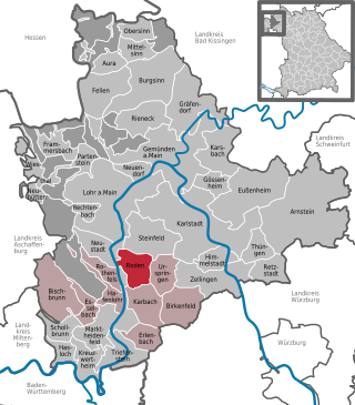
Roden is a community in the Main-Spessart district in the Regierungsbezirk of Lower Franconia (Unterfranken) in Bavaria, Germany and a member of the Verwaltungsgemeinschaft of Marktheidenfeld.

<span class="mw-page-title-main">Heidenheim, Bavaria</span> Municipality in Bavaria, Germany

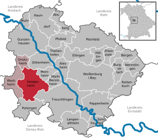
Heidenheim is a municipality in the Weißenburg-Gunzenhausen district, in Bavaria, Germany.

References

  1. Liste der ersten Bürgermeister/Oberbürgermeister in kreisangehörigen Gemeinden, Bayerisches Landesamt für Statistik, 15 July 2021.
  2. "Tabelle 12411-003r Fortschreibung des Bevölkerungsstandes: Gemeinden, Stichtag" (in German). Bayerisches Landesamt für Statistik. June 2022.
  3. 1 2 Wikisource-logo.svg One or more of the preceding sentences incorporates text from a publication now in the public domain : Chisholm, Hugh, ed. (1911). "Heilsbronn". Encyclopædia Britannica . Vol. 13 (11th ed.). Cambridge University Press. pp. 212–213.