
A fumarole is a vent in the surface of the Earth or other rocky planets from which hot volcanic gases and vapors are emitted, without any accompanying liquids or solids. Fumaroles are characteristic of the late stages of volcanic activity, but fumarole activity can also precede a volcanic eruption and has been used for eruption prediction. Most fumaroles die down within a few days or weeks of the end of an eruption, but a few are persistent, lasting for decades or longer. An area containing fumaroles is known as a fumarole field.

Katmai National Park and Preserve is an American national park and preserve in southwest Alaska, notable for the Valley of Ten Thousand Smokes and for its brown bears. The park and preserve encompass 4,093,077 acres, which is between the sizes of Connecticut and New Jersey. Most of the national park is a designated wilderness area. The park is named after Mount Katmai, its centerpiece stratovolcano. The park is located on the Alaska Peninsula, across from Kodiak Island, with headquarters in nearby King Salmon, about 290 miles (470 km) southwest of Anchorage. The area was first designated a national monument in 1918 to protect the area around the major 1912 volcanic eruption of Novarupta, which formed the Valley of Ten Thousand Smokes, a 40-square-mile (100 km2), 100-to-700-foot-deep pyroclastic flow. The park includes as many as 18 individual volcanoes, seven of which have been active since 1900.

The Indonesian island of Java is almost entirely of volcanic origin, and contains numerous volcanoes, 45 of which are considered active volcanoes. As is the case for many other Indonesian islands, volcanoes have played a vital role in the geological and human history of Java. Indeed, land is created on Java as a result of lava flows, ash deposits, and mud flows (lahars). Volcanoes are a major contributor to the immense fertility of Java, as natural erosion transports volcanic material as alluvium to the island's plains, forming thick layers of fertile sediment. The benefit is not just in the immediate vicinity of the volcano, with fine ash emitted from eruptions being dispersed over wide areas.
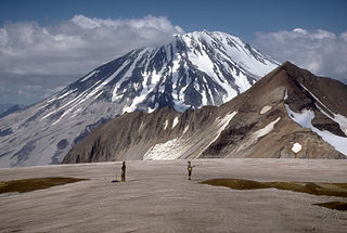
Mount Griggs, formerly known as Knife Peak Volcano, is a stratovolcano, which lies 10 km behind the volcanic arc defined by other Katmai group volcanoes. Although no historic eruptions have been reported from Mount Griggs, vigorously active fumaroles persist in a summit crater and along the upper southwest flank. The fumaroles on the southwest flank are the hottest, and some of the flank fumaroles can roar so loudly that they can be heard from the valley floor. The slopes of Mount Griggs are heavily mantled by fallout from the 1912 eruption of Novarupta volcano. The summit consists of three concentric craters, the lowest and largest of which contains a recent summit cone topped by two craters. The volume of the volcanic edifice is estimated at about 25 cubic kilometers (6.0 cu mi). Isotopic analysis indicates that the source of Griggs' magma is distinct from the other Katmai volcanoes.
Ililabalekan volcano is located on a notable peninsula within the southwestern region of Lembata Island which is a part of Indonesia, previously known as Lomblen Island. On the southeastern slope of this steep-sided Volcano, a satellite cone has formed. The summit of Mount Labalekan features four craters, including one that harbors a lava dome and two smaller explosion pits. While there is no recorded history of eruptions from this volcano, it does exhibit fumaroles near its summit.
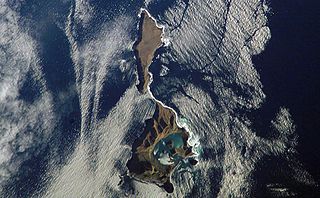
Ushishir is a collective name for two uninhabited volcanic islands and several reefs, all being parts of an eponymous partially submerged volcano, located in the centre of the Kuril Islands chain in the Sea of Okhotsk in the northwest Pacific Ocean. Its name is derived from the Ainu language for "hot spring".

Weh Island, often known as Sabang after the city from which the island is administered, is a small active volcanic island to the northwest of Sumatra, 45 minutes by fast regular ship or 2 hours by ferry from mainland, Banda Aceh. It was originally connected to the Sumatran mainland and became separated by sea after the volcano's last eruption in the Pleistocene era. The island is situated in the Andaman Sea.
Mount Kembar is a Pleistocene volcano, located in the northern Sumatra island, Indonesia. It contains a fumarole field, named Gayolesten. The volcanic complex is located in the junction of two geological fault systems and it is a shield volcano.
Perbakti is an eroded stratovolcano west of Mount Salak in West Java, Indonesia. The summit is elongated in a northwest-southwest direction, in which Gunung Endut volcano rises above the saddle of Perbakti. Two 2 km wide depressions on the northern and the southern side has formed two rivers, the Kaluwung Herang and Pamatutan rivers. Fumaroles, mud pots and hot springs are located on the south and the southeast flanks.

Wayang-Windu is a twin volcano that consists of Mount Wayang and Mount Windu. They are located just to the east of the town of Pangalengan in the Bandung Regency in West Java, Indonesia, about 40 km (25 mi) south of the city of Bandung. The area has been an active geothermal project. Mount Wayang has a 750 m (2,500 ft) wide crescentic crater which holds four groups of fumaroles. Mount Windu has a 350 m (1,100 ft) wide crater.

Mount Papandayan is a complex stratovolcano, located in Garut Regency, to the southeast of the city of Bandung in West Java, Indonesia. It is about 15 kilometres (9.3 mi) to the southwest of the town of Garut. At the summit, there are four large craters which contain active fumarole fields. An eruption in 1772 caused the northeast flank to collapse producing a catastrophic debris avalanche that destroyed 40 villages and killed nearly 3,000 people. The eruption truncated the volcano into a broad shape with two peaks and a flat area 1.1 km wide with Alun-Alun crater in the middle, making the mountain appear as a twin volcano; one of the peaks is called Papandayan and the other Mount Puntang.
Mount Kendang is a stratovolcano located in the border between Kertasari Subdistrict, Bandung Regency and Pasirwangi Subdistrict, Garut Regency, West Java, Indonesia. It contains four fumarole fields including Kawah Manuk, a broad, 2.75 km wide crater. Sulfur sublimation, mud pots and hot springs are found in the volcano.

Mount Ungaran is a deeply eroded stratovolcano, located in the south of Semarang, Central Java, Indonesia. There are no historical records about the mountain's activities. Two active fumarole fields are found on the southern flanks.
Mount Patah is the highest mountain in the Indonesian province of Bengkulu, it is a heavily forested quaternary age volcano southeast of Mount Dempo on Sumatra island, Indonesia. On 1 May 1989, a fumarole activity was observed by a pilot near the summit. The exact location of the crater, the date of its formation and its geologic relationship is uncertain.
Sekincau is a volcano with two calderas, Belirang and Balak, located in the south of Sumatra, Indonesia. A 300 m wide of crater is found at the summit. Fumarole activities are found at the foot of calderas.
Pocok Leok is a volcano in the western side of Flores island, Indonesia. The volcano was considered to be an irregular-shaped caldera, but evidence about caldera is problematic. No pyroclastic flow deposits associated with the caldera and its geological records are poorly known. However, Pocok Leok is listed in the active volcano list of Indonesia because of four fumarole activities in the area.
Ndete Napu is a fumarole field in the center of Flores island, Indonesia. It is located along the Lowomelo river valley and contains mudpots and high-pressure water fountains. The field is listed as an active volcano based on its thermal activity.

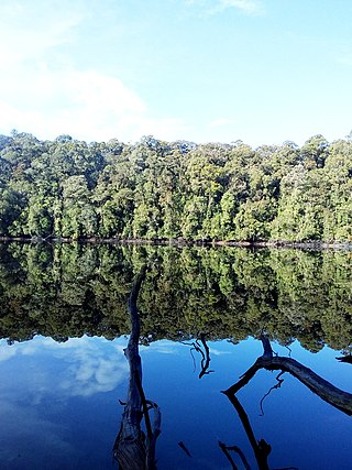
Mount Mahawu is a stratovolcano located immediately east from Lokon-Empung volcano in North Sulawesi, Indonesia. The volcano is capped with 180 m wide and 140 m deep crater with two pyroclastic cones in the northern flanks. A small explosive eruption was recorded in 1789. In 1994, fumaroles, mudpots and small geysers activities were observed along the greenish shore of a crater lake.

Mount Binuluan is a remote volcano in the Kalinga province of the Cordillera Administrative Region of the Philippines. The 2,329-metre-high (7,641 ft) mountain is part of the Cordillera Central mountain range on Luzon island, the largest island in the country. Binuluan exhibits active volcanism through numerous fumarole fields, solfataras and hot springs on its slope. There were reports of possible eruptions in 1952 and 1986, but they are unverified.
Ungaran is a town in Central Java, Indonesia and the administrative centre of the Semarang Regency in the province of Central Java. Ungaran is located at -7° 8' 17", 110° 24' 18" at an elevation of 319 metres. It encompasses two districts (kecamatan) within the Regency - Ungaran Barat and Ungaran Timur.