Richmond railway station (North Yorkshire)

Last updated

Richmond
Richmond Railway Station.jpg
Restored former railway station in 2008
General information
Location Richmond, Richmondshire
England
Coordinates 54°24′11″N1°43′44″W / 54.403°N 1.729°W / 54.403; -1.729 Coordinates: 54°24′11″N1°43′44″W / 54.403°N 1.729°W / 54.403; -1.729
Grid reference NZ176008
Platforms2
Other information
StatusDisused
History
Original company York and Newcastle Railway
Pre-grouping North Eastern Railway
Post-grouping London and North Eastern Railway
Key dates
1846opened
1969closed

Richmond railway station was a railway station that served the town of Richmond in North Yorkshire, England. The station was the terminus of a branch line that connected with what would become the East Coast Main Line.

Contents

History

Richmond station was the terminus of the now closed Eryholme-Richmond branch line. In 1845, the Great North of England Railway (GNER) was granted powers to construct a branch line from Coopers House near Dalton, six miles south of Darlington, to Richmond. While construction of the line was underway the GNER was reconstituted as the York & Newcastle Railway, and it was this company which opened the line on 1846. Although the line opened on 10 September 1846, [1] the present station at Richmond was not opened until 9 April 1847, a temporary wooden platform being provided in the interim. [2] [3]

The line from Dalton Junction (renamed Eryholme Junction in 1911) had stations at Moulton, Scorton and Catterick Bridge, and was double track throughout. These stations are rare in that they were designed in a Tudor style by architect G. T. Andrews. The exuberant architectural style of the early railway stations reflects the desire of the railway companies to promote their new form of travel as a high status experience.

The line crossed the River Swale at Easby, and terminated in the Parish of St Martin's on the south bank of the Swale opposite the town of Richmond, as it was considered "geographically impossible" to build the railway into the town. [4] The station layout consisted of two platforms for passenger trains, one which ended in a horse-loading dock, and the other was underneath the main trainshed. [5] Generous facilities were provided for goods traffic, together with facilities for railway operations and staff accommodation. The principal features were:

The station was listed in the Railway Clearing House Handbook for 1904 as being able to handle horse boxes, cattle, vans and genral goods, and was equipped with a 3-tonne (3.3-ton) crane. [11]

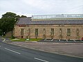
The railway also constructed a road bridge over the River Swale and built a road up into the town to provide access to the station. This bridge with four Gothic arches of 52-foot (16 m) span and a 10-foot (3 m) rise, was designed by Robert Stephenson, Engineer-in-Chief of the York & Newcastle Railway and son of George Stephenson (Although some sources credit G T Andrews). This bridge was almost unique in that it was a railway-owned bridge carrying a road over a river. It was taken over by the Town Council about 1920 but still retains its North Eastern Railway bridge plates – No 8. This bridge is now known as Mercury Bridge in honour of the close association between the town and the Royal Corps of Signals. [4]

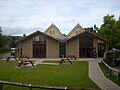
The main station building, the work of the architect George Townsend Andrews of York, was specifically designed for Richmond to blend in with the buildings and character of this historic market town. The 60-foot (18 m) wide two-ridge train shed covered a platform line and two sidings. [2] The original platform was both low and short, extending only a short distance outside the train shed. This was subsequently lengthened in 1860 and the front edge raised resulting in a downward slope towards the floor level of the offices, which survived until the recent renovations. The platform was further lengthened in 1915 to cope with the increased military traffic from the newly established Catterick Camp, and in its final form was 268 yards (245 m) long. [12]

The train shed was open at the south end and lit by gas: electricity was not provided until after the Second World War. [13] The station building included:

Later, a wooden ticket-collector's booth was provided next to the main entrance and in the 20th century there was a small wooden bookstall operated by W H Smith, which closed in 1940.

The York & Newcastle Railway survived for a further seven years after the opening of the line, becoming part of the North Eastern Railway in 1854. The NER era lasted for nearly seventy years until 1923 when it became part of the London & North Eastern Railway under the Grouping of railways following the First World War. The LNER itself lasted twenty-five years until the railways were nationalized in 1948 when Richmond became part of the North Eastern Region of British Railways.

Few substantial alterations were made to the station building over the years. As mentioned, the platform was lengthened in 1860, again in 1892, and for a second time in about 1915. The rearrangements of the offices and waiting rooms was carried out during the First World War, and at about the same time the large window at the buffer stop end of the platform was opened up to create a large door for handling parcels traffic.

The station bookstall was removed in 1940 and during the Second World War the Stationmaster's Office was requisitioned by the army as the Railway Transport Officer (RTO) Office. The RTO also had a temporary wooden office under the Port Cochere. Electric lighting was finally installed in the late 1940s, but apart from that little was spent on the building in British Railways days. In the 1950s the rotten wooden screen above the platform lone was patched with zinc sheeting, and by the time of closure there were gaps in the wooden screen, smoke louvres and roof lights.

BR proposed closure of the line in 1963 but this was vigorously opposed by the local community and the proposal was withdrawn. However, the line was gradually run down over the next few years. Goods traffic was withdrawn in 1967 and this enabled the railway to lift all the sidings, including the two in the train shed, and remove all the signals. The station was finally closed on 3 March 1969. [14] The remaining track was lifted in 1970 and the building lay derelict until the whole site was acquired by the District Council.

Before the line was closed the station was included in the List of Buildings of Special Architectural or Historic Interest: it is a Grade II* listed building. [15] [13]

After closure

The station complex consists of Station Bridge, renamed Mercury Bridge in 1975, the passenger terminus, the goods shed, engine shed, gas house, depot manager's house, Station Cottages and the station master's house. The houses were sold off and still survive.

The goods shed was demolished, and later the site was re-used for the swimming baths, [16] but the rest of the railway infrastructure survives including the bridge which continues to form part of the main road between Richmond and Catterick Garrison, the A6136.

Eventually the passenger terminus became a Farm and Garden Centre, which closed in 2001. [17]

In 2003 a community-based project to regenerate Richmond Station was given the go-ahead. [13] The aims of the project, which was spearheaded by the Richmondshire Building Preservation Trust, were:

The building re-opened – named simply The Station – in November 2007, with two cinema screens, a restaurant and café-bar, an art gallery, a heritage centre, a number of rooms for public use, and a range of artisan food-producers. [13]

See also

Related Research Articles

<span class="mw-page-title-main">North Cowton</span> Village and civil parish in North Yorkshire, England

North Cowton is a village and civil parish, located in Richmondshire, North Yorkshire, England. It is 8 miles (13 km) north-west of the county town of Northallerton.

<span class="mw-page-title-main">Brompton-on-Swale</span> Village and civil parish in North Yorkshire, England

Brompton-on-Swale is a village and civil parish in the Richmondshire district of North Yorkshire, England. The village is located three miles east of Richmond and 10 miles (16 km) north-west of the county town of Northallerton on the northern bank of the River Swale.

<span class="mw-page-title-main">Pickering railway station</span> Heritage railway station in North Yorkshire, England

Pickering railway station is the southern terminus of the North Yorkshire Moors Railway and serves the town of Pickering in North Yorkshire, England. The first railway arrived in Pickering from the north in 1836, however, it wasn't until the railway was connected from the south in 1845, that the current station was built. The station was closed by British Railways in March 1965, but since 1975, the station has served as the southern terminus of the North York Moors Railway.

<span class="mw-page-title-main">Goathland railway station</span> Railway station in North Yorkshire, England

Goathland railway station is a station on the North Yorkshire Moors Railway and serves the village of Goathland in the North York Moors National Park, North Yorkshire, England. It has also been used in numerous television and film productions. Holiday accommodation is available in the form of a camping coach.

<span class="mw-page-title-main">Moulton End</span> Hamlet in North Yorkshire, England

Moulton End is a hamlet in North Yorkshire, in England.

<span class="mw-page-title-main">Eryholme–Richmond branch line</span>

The Eryholme–Richmond branch line was opened in 1846 by the York and Newcastle Railway Company. The original section of the line ran from between a point in between Darlington and Northallerton on what is now the East Coast Main Line and the terminus at Richmond railway station.

<span class="mw-page-title-main">Scorton, North Yorkshire</span> Village and civil parish in North Yorkshire, England

Scorton is a village and civil parish in the Richmondshire district of North Yorkshire, England. It is approximately 8 miles (13 km) north-west of the county town of Northallerton.

<span class="mw-page-title-main">Moulton railway station (North Yorkshire)</span> Disused railway station in North Yorkshire, England

Moulton railway station was a railway station in what is now the Richmondshire district of North Yorkshire, England. It was situated near the village of North Cowton.

<span class="mw-page-title-main">Scorton railway station</span> Disused railway station in North Yorkshire, England

Scorton railway station was a railway station in what is now the Richmondshire district of North Yorkshire, England. The village of Scorton is situated around 0.5 miles (0.8 km) south from the site of the station.

<span class="mw-page-title-main">Hudswell, North Yorkshire</span> Village and civil parish in North Yorkshire, England

Hudswell is a village and civil parish on the border of the Yorkshire Dales, in the Richmondshire district of North Yorkshire, England. The population at the ONS Census 2011 was 353.

<span class="mw-page-title-main">Fleetwood railway station</span> Station in Lancashire, UK (1840–1966)

There have been three locations for Fleetwood railway station in Fleetwood, Lancashire, England. The first, from 1840 to 1883, was in Dock Street, opposite Church Street. The second, from 1883 to 1966, was in Queen's Terrace. From 1966 to 1970, the station previously known as Wyre Dock railway station was renamed "Fleetwood".

<span class="mw-page-title-main">Catterick Bridge railway station</span> Disused railway station in North Yorkshire, England

Catterick Bridge railway station was a railway station in what is now the Richmondshire district of North Yorkshire, England. It was built to serve the villages of Brompton-on-Swale and Catterick. The station was near the junction between the main branch line towards Richmond and a sub-branch line called Catterick Camp Military Railway to what is now Catterick Garrison.

<span class="mw-page-title-main">Brompton Road Halt railway station</span> Disused railway station in North Yorkshire, England

Brompton Road Halt was a railway station in what is now the Richmondshire district of North Yorkshire, England. It was located on the Catterick Camp sub branch of the Eryholme-Richmond branch line and served the village of Brompton-on-Swale.

Catterick Camp railway station was a railway station in what is now the Richmondshire district of North Yorkshire, England. It was built as the terminus of the sub branch of the Eryholme-Richmond branch line to serve Catterick Camp, now Catterick Garrison. Along with the rest of the stations on the branch it was closed in 1964.

Stainland and Holywell Green railway station served the villages of Stainland and Holywell Green in West Yorkshire, England from 1875 until 1929. Goods services ended in 1959. It was situated in the eastern part of Holywell Green.

<span class="mw-page-title-main">Nidd Valley Railway</span> Disused railway line in Yorkshire, England

The Nidd Valley Railway was a 11.5-mile (18.5 km) long single track branch railway line that ran along the valley of the River Nidd in North Yorkshire, England. Built by the North Eastern Railway, it ran from Ripley Junction, on the Harrogate to Ripon Line, to Pateley Bridge via five intermediate stations, Ripley Valley, Hampsthwaite, Birstwith, Darley, and Dacre.

<span class="mw-page-title-main">Darley railway station</span> Disused railway station in North Yorkshire, England

Darley railway station served the village of Darley, North Yorkshire, England from 1864 to 1951 on the Nidd Valley Railway.

<span class="mw-page-title-main">Masham railway station</span> Disused railway station in North Yorkshire, England

Masham railway station was the terminus of the Melmerby to Masham branch line serving the town of Masham in North Yorkshire, England. It was on the eastern side of the River Ure, so as such, was actually in Burton-on-Ure. The line operated between 1875 and 1931 for passenger traffic, but was retained for minimal freight train use until 1963.

<span class="mw-page-title-main">St Martin's, North Yorkshire</span> Civil parish in North Yorkshire, England

St Martin's is a civil parish in North Yorkshire, England. It is located south of the town of Richmond, covering the residential areas south of the River Swale, including the former Richmond railway station and Holly Hill.

Lofthouse-in-Nidderdale railway station was the northernmost regular passenger terminus on the Nidd Valley Light Railway (NVLR), in Lofthouse, then in the West Riding of Yorkshire and now in North Yorkshire, England. The station was built as part of Bradford Corporation's programme of reservoir building in the Upper Nidd Valley. The station opened in 1904 and was closed to passengers in 1930. The station was renamed Lofthouse-in-Nidderdale railway station in 1907 to avoid confusion with Lofthouse and Outwood railway station, also in the West Riding of Yorkshire.

References

  1. Suggitt 2005, p. 46.
  2. 1 2 Fawcett 2011, p. 165.
  3. Young 2015, p. 27.
  4. 1 2 Hatcher, C. J. (1990). Richmondshire architecture. Richmond, North Yorkshire: C. J. Hatcher. p. 224. ISBN   0951588001.
  5. Blakemore 2005, pp. 56, 58.
  6. 1 2 3 Blakemore 2005, p. 54.
  7. Historic England. "Station House (Grade II) (1317113)". National Heritage List for England . Retrieved 10 October 2022.
  8. 1 2 3 4 Young 2015, p. 29.
  9. Historic England. "Station Cottages (Grade II) (1301469)". National Heritage List for England . Retrieved 10 October 2022.
  10. Addeyman, John F., ed. (2020). North Eastern Railway Engine Sheds. North Eastern Railway Association. p. 146. ISBN   978-1-911360-26-1.
  11. The Railway Clearing House handbook of railway stations, 1904. Newton Abbot: David & Charles. 1970. p. 459. ISBN   0715351206.
  12. Young 2015, p. 30.
  13. 1 2 3 4 Young 2015, p. 32.
  14. Suggitt 2005, p. 49.
  15. Historic England. "Richmond Garden And Farm Supply Centre (1157668)". National Heritage List for England . Retrieved 27 November 2020.
  16. Hoole, K. (1985). Railway stations of the North East. Newton Abbot: David & Charles. p. 182. ISBN   0-7153-8527-5.
  17. Blakemore 2005, p. 57.

Sources

Preceding station Disused railways Following station
Catterick Bridge   Eryholme-Richmond branch line  Terminus