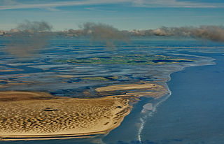
Texel is a municipality and an island with a population of 13,641 in the province of North Holland in the Netherlands. It is the largest and most populated island of the West Frisian Islands in the Wadden Sea. The island is situated north of Den Helder, northeast of Noorderhaaks, also known as "Razende Bol" and southwest of Vlieland.
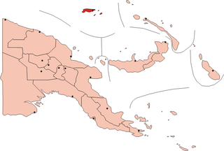
The Admiralty Islands are an archipelago group of 18 islands in the Bismarck Archipelago, to the north of New Guinea in the South Pacific Ocean. These are also sometimes called the Manus Islands, after the largest island.
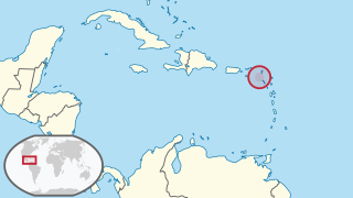
Saba is a Caribbean island which is the smallest special municipality of the Netherlands. It consists largely of the potentially active volcano Mount Scenery, at 887 metres (2,910 ft) the highest point of the entire Netherlands.
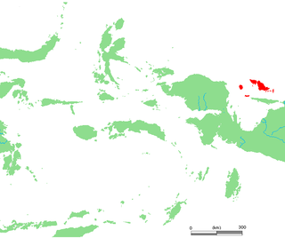
The Schouten Islands are an island group of Papua province, eastern Indonesia in the Cenderawasih Bay 50 km off the north-western coast of the island of New Guinea. The group consists of the main islands of Biak, Supiori and Numfor, and numerous smaller islands, mostly covered in rain forest.

The West Frisian Islands are a chain of islands in the North Sea off the Dutch coast, along the edge of the Wadden Sea. They continue further east as the German East Frisian Islands and are part of the Frisian Islands.

Seram is the largest and main island of Maluku province of Indonesia, despite Ambon Island's historical importance. It is located just north of smaller Ambon Island and a few other surrounding islands, such as Haruku, Geser, Nusalaut, Banda and Saparua.

The Frisian Islands, also known as the Wadden Islands or the Wadden Sea Islands, form an archipelago at the eastern edge of the North Sea in northwestern Europe, stretching from the northwest of the Netherlands through Germany to the west of Denmark. The islands shield the mudflat region of the Wadden Sea from the North Sea.

West Papua is a province of Indonesia. It covers the two western peninsulas of the island of New Guinea along with nearby islands. The province is bordered to the north by the Pacific Ocean, to the west by the Halmahera Sea and the Ceram Sea, to the south by the Banda Sea, and to the east by the province of Papua and the Cenderawasih Bay. Manokwari is the capital, while Sorong is the largest city and the main gateway to the province. According to the 2010 census by Statistics Indonesia, West Papua recorded a population of 760,422. Inaugurated as a province in 2003, West Papua was initially named West Irian Jaya until 2007. The name West Papua itself is also used by the Free Papua Movement to refer the whole Western New Guinea. Consisting of twelve regencies and one city, the province enjoys a special autonomous status as granted by the Indonesian legislation. West Papua is well known by its Raja Ampat Islands which contains the richest marine biodiversity in the world.

Launched in 1759, the third HMS Supply was a Royal Navy armed tender that played an important part in the foundation of Australia. The Navy sold her in 1792. She then served commercially until c. 1806.

Isla de Aves, or Aves Island, is a Caribbean dependency of Venezuela. It has been the subject of numerous territorial disputes between the neighboring independent islands, such as Dominica, and European mother countries of surrounding dependent islands, such as the Netherlands. It is part of the Aves Ridge and lies to the west of the Windward Islands chain at 15°40′18″N63°36′59″W. It is 375 metres (1,230 ft) in length and never more than 50 metres (160 ft) in width, and rises 4 metres (13 ft) above the sea on a calm day. Under a particular interpretation of the United Nations Convention on the Law of the Sea it could be classified as a rock, which would only give Venezuela a twelve nautical mile economic zone. However, Venezuela claims it is an island, which grants it a 200-mile (320 km) exclusive economic zone. Mostly sand, a small portion has some scrubby vegetation. It is sometimes completely submerged during hurricanes. It is 185 kilometres (115 mi) southwest of the closest land, Montserrat, 225 kilometres (140 mi) west of Dominica and 547 kilometres (340 mi) north of the Venezuelan mainland.

Western New Guinea, also known as Papua, is the Indonesian part of the island of New Guinea. Since the island is also named as Papua, the region is sometimes called West Papua. Lying to the west of the independent state of Papua New Guinea, it is the only Indonesian territory to be situated in Oceania. The territory is mostly in the Southern Hemisphere and also includes nearby islands, including the Schouten and Raja Ampat archipelagoes. The region is predominantly covered with ancient rainforest where numerous traditional tribes live such as the Dani of the Baliem Valley, although a large proportion of the population live in or near coastal areas, with the largest city being Jayapura.

Munroe Island or Mundrothuruthu is an inland island located at the confluence of Ashtamudi Lake and the Kallada River, in Kollam district, Kerala, South India. The island, accessible by road, rail and inland water navigation, is about 25 kilometres (16 mi) from Kollam by road, 38 kilometres (24 mi) north from Paravur, 12 kilometres (7.5 mi) west from Kundara and about 25 kilometres (16 mi) from Karunagapally. As of the 2011 Indian census, the administrative village of Mundrothuruth has a total population of 9599, consisting of 4636 males and 4963 females.
The Ait Ouriaghel is the biggest Berber tribe of the Rif region of the north-eastern part of Morocco. Ait Waryagher means "those who do not back off/ those who do not retreat". They inhabit most of the territory around the city of Al Hoceima. The Ayt Waryaghar speak the "Western-Tarifit" dialect of the Riffian language.

The Bird's Head Peninsula or Doberai Peninsula is a large peninsula that makes up the northwest portion of the island of New Guinea and the major part of the Province of West Papua, Indonesia. The other edge is on the Bird's Tail Peninsula.

Cenderawasih Bay, also Teluk Sarera, formerly Geelvink Bay is a large bay in northern Province of Papua and West Papua, New Guinea, Indonesia.

St Peter Island is an island in the Nuyts Archipelago on the west coast of Eyre Peninsula in South Australia near Ceduna. It is the second largest island in South Australia and about 13 km (8.1 mi) long. It was one of the first parts of South Australia to be discovered and named by Europeans, along with St Francis Island, mapped by François Thijssen in 't Gulden Zeepaert in 1627.
St Francis Island is an island on the south coast of South Australia near Ceduna. It is part of the Nuyts Archipelago. It was one of the first parts of South Australia to be discovered and named by Europeans, along with St Peter Island, mapped by François Thijssen in 't Gulden Zeepaert in 1627.

New Guinea or Papua (Tok Pisin: Niugini; Dutch: Nieuw-Guinea; German: Neuguinea; Indonesian: Papua, is a large island separated by a shallow sea from the rest of the Australian continent. It is the world's second-largest, after Greenland, covering a land area of 785,753 km2, and the largest wholly or partly within the Southern Hemisphere and Oceania.