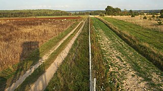
Lithuania Minor or Prussian Lithuania is a historical ethnographic region of Prussia, later East Prussia in Germany, where Prussian Lithuanians or Lietuvininkai lived. Lithuania Minor enclosed the northern part of this province and got its name due to the territory's substantial Lithuanian-speaking population. Prior to the invasion of the Teutonic Knights in the 13th century, the main part of the territory later known as Lithuania Minor was inhabited by the tribes of Skalvians and Nadruvians. The land became depopulated to some extent during the warfare between Lithuania and the Order. The war ended with the Treaty of Melno and the land was resettled by Lithuanian newcomers, returning refugees, and the remaining indigenous Baltic peoples; the term Lithuania Minor appeared for the first time between 1517 and 1526. With the exception of the Klaipėda Region, which became a mandated territory of the League of Nations in 1920 by the Treaty of Versailles and was annexed to Lithuania from 1923 to 1939, the area was part of Prussia until 1945. Today a small portion of Lithuania Minor is within the borders of modern Lithuania and Poland while most of the territory is part of the Kaliningrad Oblast of Russia.

Mažeikiai District Municipality is located in the north-west of Lithuania, on the River Venta in Telšiai County. The administrative center of Mažeikiai District is the city of Mažeikiai. Its territory of 1,220.2 km² is composed of 32 km² of towns and settlements, 22 km² of industrial enterprises and roads, 614 km² of agricultural lands, 273 km² of forests, and 68 km² of tracts of other designation. There is one urban and 8 rural elderates. In 2003, the population was 67,393. Of this number, 46,223 live in towns and 21,170 in villages.

Marcinkonys is a village in Varėna district, Lithuania, located south-east of Merkinė. It is the administrative center of the Dzūkija National Park and Čepkeliai Marsh. According to the 2001 census, it had 765 residents.
Kaunas District Municipality is one of 60 municipalities in Lithuania. The seat of the municipality is the city of Kaunas. It surrounds the Kaunas City Municipality from the north, west and south, while in the east Kaunas district municipality borders Kaišiadorys District Municipality. Kaunas District Municipality has the second largest international airport in Lithuania, and is well connected by major roads, as well as railways with other cities of Lithuania.

Linkuva is a city in the Pakruojis district municipality, Lithuania. It is located 18 km (11 mi) north-east of Pakruojis.The town is more than 500 years old.

Senieji Trakai is a historic Lithuanian village located 3 kilometres (1.9 mi) east of Trakai. According to the Lithuanian census of 2011, it has 1,396 inhabitants – Lithuanians, Poles and Russians. The Saint Petersburg – Warsaw Railway passes through Senieji Trakai.

Paliepiai is a village in Lithuania located 6 km east of Viduklė. According to the 2001 census, it had 518 residents.

Stakliškės is a village in Lithuania, located east of Prienai, in Prienai district of Kaunas County on the Prienai-Trakai road. Stakliškės is a center of Stakliškės elderate. The famous type of Lithuanian mead, an alcoholic beverage distilled from grain, honey and water is produced in Stakliškės. According to the 2011 census, the village had 747 residents.
Mateikonys is a village in the Šalčininkai district municipality, Lithuania near the border with Belarus. According to the 2011 census it had population of 160.
Žvaigždžiakalnis is a village in the Molėtai district municipality, in Utena County, eastern Lithuania. According to the 2001 census, the village has a population of 4 people. The village is located in a remote area 10 km south east from Suginčiai, in a peninsula at the western edge of the Lake Aisetas. Žvaigždžiakalnis is surrounded by forest and is part of the Labanoras Regional Park.

Skaidiškės is a village in Vilnius district municipality, Vilnius County, east Lithuania. According to the Lithuanian census of 2011, the town has a population of 4,133 people. It is the second largest village in Lithuania.
Rudamina is a village in Vilnius district municipality, Vilnius County, east Lithuania. As of the 2001 census, the town had a population of 3937 people. The village has a Catholic church.
Čiulai is a small village, located about 4 kilometres (2.5 mi) east of Mindūnai along the Highway 114 in the municipality of Molėtai, Lithuania. As of 2011, it had a population of 38 people. Two small lakes lie to the southeast of the village, Tramys I and II and the larger Baltieji Lakajai.

The Visaginas Municipality is one of the 60 municipalities of Lithuania, situated in the north-east of the country. It consists of the city of Visaginas, 16 villages (kaimai) and one farmstead (viensėdis).

Voškoniai is a village in the Kaunas district municipality, Lithuania. It is located 3 km (1.9 mi) north east of Domeikava. Eigirgala library, established in 1953, is in Voškoniai. According to the 2011 census, the village had 880 residents.
Dysna is a village in the eastern part of Ignalina district in Lithuania. According to the 2011 census, it had 62 residents. It is located 12 kilometres (7.5 mi) east of Tverečius, near the border with Belarus. The village is situated on the right bank of the river Dysna, which gives the village its name. The village has a chapel, section of Didžiasalis school, and public library.

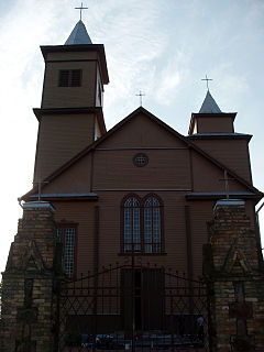
Vosiūnai is a village in the eastern part of Ignalina district in Lithuania. According to the 2011 census, it had 29 residents. It is located 5 kilometres (3.1 mi) east of Navikai, near the border with Belarus. The village is situated on the right bank of the river Dysna. The village has a wooden Blessed Virgin Mary Church.

Galalaukiai is a village in the eastern part of Ignalina district in Lithuania. It is located 1 kilometres east of Didžiasalis and 1 kilometres east of Dysna village near the border with Belarus. According to the 2011 census, it had 25 residents.

Steigviliai is a village in the northeastern Pakruojis District Municipality, Lithuania. It is located 4 kilometres (2.5 mi) north from Ūdekai and east of the Beržtalis river. According to the 2011 census, it had 76 residents. The village has many surviving authentic masonry and wooden residential houses and barns, including a windmill. Agricultural firm "Žiemagra" is based in the village.