
North Yorkshire is a ceremonial county in the Yorkshire and the Humber and North East regions of England. It borders County Durham to the north, the North Sea to the east, the East Riding of Yorkshire to the south-east, South Yorkshire to the south, West Yorkshire to the south-west, and Cumbria and Lancashire to the west.

Thornaby-on-Tees, commonly referred to as Thornaby, is a town and civil parish in the North Yorkshire part of the borough of Stockton-on-Tees, England. The parish had a population of 24,741 at the 2011 census, in the Teesside built-up area. It is located on the south bank of the River Tees.
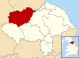
Richmondshire was a local government district of North Yorkshire, England, from 1974 to 2023. It covered a large northern area of the Yorkshire Dales including Swaledale and Arkengarthdale, Wensleydale and Coverdale, with the prominent Scot's Dyke and Scotch Corner along the centre. Teesdale lay to the north. With a total area of 1,319 km2, it was larger than seven of the English ceremonial counties.

Catterick Garrison is a major garrison and military town 3 miles (5 km) south of Richmond, North Yorkshire, England. It is the largest British Army garrison in the world, with a population of around 13,000 in 2017 and covering over 2,400 acres.
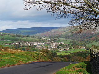
Reeth is a village 11 miles (18 km) west of Richmond in North Yorkshire, England, in the civil parish of Reeth, Fremington and Healaugh. Historically part of the North Riding of Yorkshire, it is the principal settlement of upper Swaledale.

Colburn is a town, civil parish and electoral ward in North Yorkshire, England, 2 miles (3.2 km) west of Catterick. It had a population of 4,860 at the 2011 census, rising from 3,606 in 2001.

Catterick is a village, civil parish and electoral ward in North Yorkshire, England. Historically part of the North Riding of Yorkshire, it is 8.5 miles (13.7 km) north-west of the county town of Northallerton just to the west of the River Swale. It lends its name to nearby Catterick Garrison and the nearby hamlet of Catterick Bridge, the home of Catterick Racecourse where the village Sunday market is held. It lies on the route of the old Roman road of Dere Street and is the site of the Roman fortification of Cataractonium.

Brough with St Giles is a village and a civil parish in North Yorkshire, England. The civil parish also includes the settlements of Catterick Bridge and Walkerville, and Catterick Racecourse and the site of the Roman town of Cataractonium. According to the 2001 Census the parish had a population of 338, increasing to 801 at the 2011 census.
Lincolnshire is one of the few counties within the UK that still uses the eleven-plus to decide who may attend grammar school, in common with Buckinghamshire and Kent.

Hipswell is a village and civil parish in the North Yorkshire (district) of the county of the same name. The civil parish mainly comprises the northern part of Catterick Garrison. The village of Hipswell is at the eastern end of the civil parish, and effectively forms a suburb of Catterick Garrison.

Scotton is a village, civil parish and electoral ward in the Richmondshire district of North Yorkshire, England. The civil parish includes the centre and south of Catterick Garrison. The village lies in the south of the civil parish, and is effectively a suburb of Catterick Garrison. The village of Scotton is located 3+1⁄4 miles south west of Catterick village.

Northallerton School is a coeducational secondary school and sixth form located in Northallerton, North Yorkshire, England. The school is located over two sites on Brompton Road and Grammar School Lane.

Harrogate High School is a comprehensive secondary school in Harrogate, North Yorkshire, England. It has about 720 pupils on roll and approximately 85 full-time teaching staff. The school was awarded specialist Sports College status. The Academy Head is Sukhraj Gill.

Hudswell is a village and civil parish on the border of the Yorkshire Dales, in North Yorkshire, England. The population at the ONS Census 2011 was 353.

The A6108 road is an A road in North Yorkshire, England. It runs from the south of Scotch Corner to Ripon going via Richmond and Leyburn across the moors and the valleys of Swaledale and Wensleydale. The road is 37 miles (60 km) long, but through traffic between the two destinations will find a shorter route of 26 miles (42 km) by going south on the A1. The route is single carriageway for its entire length.
Risedale Beck is a small river that rises on Hipswell Moor, near Catterick Garrison in North Yorkshire, England. The name derives from Old Norse as meaning either Risi's Valley or translated as a valley overgrown with brushwood. Risedale Beck flows eastwards into Catterick Garrison as Leadmill Gill, which in turn flows into Colburn Beck, a tributary of the River Swale. The length of the beck from source to the River Swale is 6.5 miles (10.4 km).
Furness Academy is a secondary school in Barrow-in-Furness, England. It is the fourth academy to have been formed in the county of Cumbria after the closure of Alfred Barrow School, Parkview Community College of Technology and Thorncliffe School in 2009. Having utilised numerous buildings of the former Parkview and Thorncliffe Schools since 2009, a single £22 million building opened in the Parkside area of the town in September 2013.
Stokesley School is a coeducational secondary school and sixth form located in Stokesley, North Yorkshire, England.

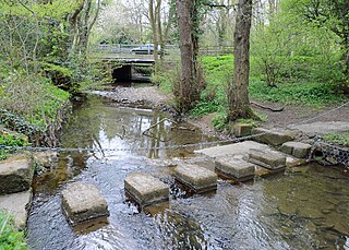
Foxglove Covert is a Local Nature Reserve (LNR) located on Catterick Garrison in North Yorkshire, England and is on the eastern edge of the Yorkshire Dales. The reserve was created in 1992 by The Royal Scots Dragoon Guards who had just returned from the First Gulf War. The reserve has been visited by royalty and has won many awards for its activities.
