Moyle District Council was a local council in County Antrim in the northeast of Northern Ireland. It merged with Ballymoney Borough Council, Coleraine Borough Council and Limavady Borough Council in May 2015 under local government reorganisation to become Causeway Coast and Glens District Council.
This is a list of the extreme points of Ireland – the points that are farthest north, south, east or west in Ireland. It includes the Republic of Ireland and Northern Ireland.

The Glens of Antrim, known locally as simply The Glens, is a region of County Antrim, Northern Ireland. It comprises nine glens (valleys), that radiate from the Antrim Plateau to the coast. The Glens are an area of outstanding natural beauty and are a major tourist attraction in north Antrim. The main towns and villages in the Glens are Ballycastle, Cushendun, Cushendall, Waterfoot, Carnlough and Glenarm. The Glens are mentioned in the song "Ireland's Call".

The A2 is a major road in Northern Ireland, a considerable length of which is often referred to the Antrim Coast Road because much of it follows the scenic coastline of County Antrim; other parts of the road follow the coasts in Counties Down and Londonderry.
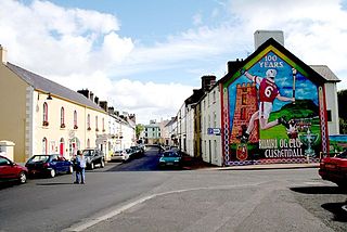
Cushendall, formerly known as Newtown Glens, is a village and townland in County Antrim, Northern Ireland. It is located in the historic barony of Glenarm Lower and the civil parish of Layd, and is part of Causeway Coast and Glens district.
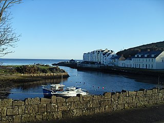
Cushendun is a small coastal village in County Antrim, Northern Ireland. It sits off the A2 coast road between Cushendall and Ballycastle. It has a sheltered harbour and lies at the mouth of the River Dun and Glendun, one of the nine Glens of Antrim. The Mull of Kintyre in Scotland is only about 15 miles away across the North Channel and can be seen easily on clear days. In the 2001 Census it had a population of 138 people. It is part of Causeway Coast and Glens district.
Barmeen is a townland in County Antrim, Northern Ireland. It is located at the foot of Glendun, one of the nine Glens of Antrim, west of Cushendun and north of Knocknacarry. It is situated in the historic barony of Cary and the civil parish of Culfeightrin and covers 59 acres.
Knocknacarry is a hamlet and townland about 1 kilometre west of Cushendun in County Antrim, Northern Ireland. It is situated in the historic barony of Glenarm Lower and the civil parish of Layd. In the 2001 Census it had a population of 138 people. It is within the Moyle District Council area.
Ballyvoy is a small village and townland in County Antrim, Northern Ireland. It is on the main A2 coast road 5 km east of Ballycastle and 17 km north west of Cushendall. In the 2001 Census it had a population of 72 people. It lies within the Antrim Coast and Glens Area of Outstanding Natural Beauty and is part of Causeway Coast and Glens District Council.

Glendun translates into English as glen of the brown river and is one of the nine Glens of Antrim in County Antrim in Northern Ireland.
Dollaghan are a variety of brown trout native to Lough Neagh, Northern Ireland, and many of its tributaries. They are a potamodromous migratory trout spending much of the year in the lough, returning to the rivers in autumn to spawn. Dollaghan are much sought after by anglers in County Antrim County Tyrone and Derry due to their greater size in comparison to the non-migratory trout found in streams such as the Ballinderry River Six Mile Water, Moyola River and River Main. They are often caught in the dark using methods very similar to that of fishing for sea trout. Many anglers regard them as an elusive species and call them 'sea trout of lough neagh'. Their weight varies greatly - from small fish of around 1/2 lb to large specimens of around 20 lb. There are four strains of brown trout in Ireland: Dollaghan, Gillaroo, Sonaghan and Ferox. The Dollaghan is thought to have evolved from sea trout which were land locked many years ago.

Tievebulliagh is a 554-metre high mountain in the Glens of Antrim, Northern Ireland. It forms part of the watershed between Glenaan to the north and Glenballyemon to the south. It is situated about 4.4 km from Cushendall.

The Shimna River is a river in County Down, Northern Ireland. It rises on the slopes of Ott Mountain, in the Mourne Mountains, and enters the Irish Sea at Newcastle, on Dundrum Bay. It is acidic and nutrient-poor, as a result of which its most common flora are mosses and liverworts, including the rare Portuguese feather-moss and Holt's mouse-tail moss. Its principal fish are salmon and sea trout, and it is managed by the Shimna Angling Club. The river is an Area of Special Scientific Interest (ASSI).

The Castletown River is a river which flows through the town of Dundalk, County Louth, Ireland. It rises near Newtownhamilton, County Armagh, Northern Ireland, and is known as the Creggan River in its upper reaches. Its two main tributaries are the Kilcurry and Falmore rivers and it enters the Irish Sea at Dundalk Bay on the east coast of Ireland. The Castletown River flows in at the northwest corner of Dundalk Bay creating a deep channel through the intertidal zone. It is routinely dredged for navigation purposes for the deep water port of Dundalk.

The River Bush is a river in County Antrim, Northern Ireland. The River Bush is 33.5 miles (53.9 km) long. The river's source is in the Antrim Hills at 480m. From there the river flows northwest, with a bend at the town of Armoy. It then flows west, passing through Stranocum, and then bends north, passing through Bushmills before reaching the sea at Portballintrae on the North Antrim coast. It flows through a fertile valley devoted to grassland-based agriculture with limited arable cropping. The underlying geology is basalt and the water is slightly alkaline with magnesium making an unusually large contribution to total hardness. The river supports indigenous stocks of Atlantic salmon and brown trout. Saint Columb's Rill, which is a tributary of the river, is the source of water used for distilling Bushmills whiskey.

Newtowncrommelin is a small village and civil parish in County Antrim, Northern Ireland. It lies 8 miles north-northeast of Ballymena and is part of the Borough of Ballymena. The village of Newtowncrommelin was founded in the townland of Skerry.

The A42 is an east-west route in Northern Ireland. It starts in Maghera in County Londonderry, from where it goes in the direction of Carnlough on the shores of the North Channel of the Irish Sea, at the foot of the Glens of Antrim. The road goes through Gulladuff and Clady, as well as Portglenone, Ahoghill, Ballymena Broughshane and The Sheddings.

Causeway Coast and Glens is a local government district covering most of the northern part of Northern Ireland. It was created on 1 April 2015 by merging the Borough of Ballymoney, the Borough of Coleraine, the Borough of Limavady and the District of Moyle. The local authority is Causeway Coast and Glens Borough Council.

Glenshesk is one of the nine Glens of Antrim in County Antrim, Northern Ireland. It was shaped during the Ice Age by glaciers. The glen lies on the eastern side of Knocklayde mountain and flows out to the sea at Ballycastle.
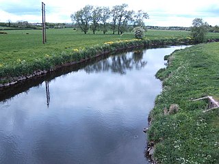
The River Main or Maine is a river in Northern Ireland, flowing through County Antrim.