
Perthshire, officially the County of Perth, is a historic county and registration county in central Scotland. Geographically it extends from Strathmore in the east, to the Pass of Drumochter in the north, Rannoch Moor and Ben Lui in the west, and Aberfoyle in the south; it borders the counties of Inverness-shire and Aberdeenshire to the north, Angus to the east, Fife, Kinross-shire, Clackmannanshire, Stirlingshire and Dunbartonshire to the south and Argyllshire to the west. It was a local government county from 1890 to 1930.

Perth is a city in central Scotland, on the banks of the River Tay. It is the administrative centre of Perth and Kinross council area and the historic county town of Perthshire. It had a population of about 47,430 in 2018.

Perth and Kinross is one of the 32 council areas of Scotland and a Lieutenancy Area. It borders onto the Aberdeenshire, Angus, Argyll and Bute, Clackmannanshire, Dundee, Fife, Highland and Stirling council areas. Perth is the administrative centre. With the exception of a large area of south-western Perthshire, the council area mostly corresponds to the historic counties of Perthshire and Kinross-shire.

Pitlochry is a town in the county of Perthshire in Scotland, lying on the River Tummel. It is administered as part of the council area of Perth and Kinross, and has a population of 2,776, according to the 2011 census.

Blair Atholl is a village in Perthshire, Scotland, built about the confluence of the Rivers Tilt and Garry in one of the few areas of flat land in the midst of the Grampian Mountains. The Gaelic place-name Blair, from blàr, 'field, plain', refers to this location. Atholl, which means 'new Ireland', from the archaic Ath Fhodla is the name of the surrounding district.

Loch Tummel is a long, narrow loch, seven kilometres northwest of Pitlochry in the council area of Perth and Kinross, Scotland. It is fed and drained by the River Tummel, which flows into the River Tay about 13 km (8 mi) south-east of the Clunie Dam at the loch's eastern end.

Dunkeld is a town in Perth and Kinross, Scotland. The location of a historic cathedral, it lies on the north bank of the River Tay, opposite Birnam. Dunkeld lies close to the geological Highland Boundary Fault, and is frequently described as the "Gateway to the Highlands" due to its position on the main road and rail lines north. Dunkeld has a railway station, Dunkeld & Birnam, on the Highland Main Line, and is about 25 kilometres north of Perth on what is now the A9 road. The main road formerly ran through the town, however following modernisation of this road it now passes to the west of Dunkeld.
Killiecrankie (; is a village in Perth and Kinross, Scotland on the River Garry. It lies at the Pass of Killiecrankie, by the A9 road which has been bypassed since 1986. The village is home to a power station forming part of the Tummel Hydro-Electric Power Scheme. Much of the riverbank is owned by the National Trust for Scotland. The nearby 10 arch railway viaduct, which runs for 109 yards along the north-east bank of the River Garry, was built in 1863 from a design by Joseph Mitchell.

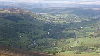
Glen Tilt is a glen in the extreme north of Perthshire, Scotland. Beginning at the confines of Aberdeenshire, it follows a South-westerly direction excepting for the last 4 miles, when it runs due south to Blair Atholl. It is watered throughout by the Tilt, which enters the Garry after a course of 14 miles, and receives on its right the Tarf, which forms some beautiful falls just above the confluence, and on the left the Fender, which has some fine falls also. The attempt of George Murray, 6th Duke of Atholl to close the glen to the public was successfully contested by the Scottish Rights of Way Society in 1847. The massive mountain of Beinn a' Ghlò and its three Munros Càrn nan Gabhar, Bràigh Coire Chruinn-bhalgain and Càrn Liath (975) dominate the glen's eastern lower half.
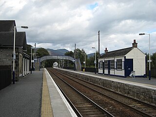
Blair Atholl railway station is a railway station serving the town of Blair Atholl, Perth and Kinross, Scotland. The station is managed by ScotRail and is on the Highland Main Line, 35 miles 9 chains (56.5 km) from Perth, between Pitlochry and Dalwhinnie.
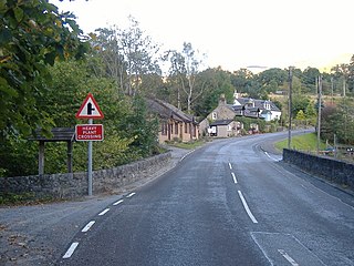
Aldclune is a village in Perth and Kinross, Scotland. It is on the B8079 road, approximately 1+1⁄2 miles east of Blair Atholl, on the north bank of the River Garry. At the eastern edge of the village is the site of the Battle of Killiecrankie, which took place in 1689 during the Jacobite rising of 1689–92.

Murthly is a village in Perth and Kinross, Scotland. It lies on the south bank of the River Tay, 5 miles southeast of Dunkeld, and 9+1⁄2 miles north of Perth. Perth District Asylum, later known as Murthly Hospital, was opened in the village on 1 April 1864 for 'pauper lunatics'. It was the second district asylum to be built in Scotland under the terms of the 1857 Lunacy (Scotland) Act. It closed in 1984 and was later demolished. The village has a stone circle, in the former grounds of the hospital. The village formerly had a railway station on the Perth and Dunkeld Railway, which closed in 1965.

The River Garry is a major tributary of the River Tummel, itself a tributary of the River Tay, in the traditional county of Perthshire in the Scottish Highlands. It emerges from the northeastern end of Loch Garry (56.8193°N 4.2311°W), just to the southeast of the Pass of Drumochter, and flows southeastwards and eastwards down Glen Garry to the narrow Pass of Killiecrankie beyond which it joins the Tummel (56.7182°N 3.7790°W).
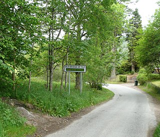
Bridge of Tilt is a village in Perthshire, Scotland, built around the River Tilt, near its confluence with the River Garry. It is 5+3⁄4 miles northwest of Pitlochry. The newer part of the village is continuous with Blair Atholl, only separated by the River Tilt. The village is located primarily on the B8079 between Pitlochry and Dunalastair Water, but the older part of the village is located further up the River Tilt. The A9 runs past the River Garry to the south of Bridge of Tilt, and connects the village with Newtonmore and Inverness in the north and Pitlochry, Perth and Stirling in the south.

Loch Loch is a remote freshwater loch, located in Glen Loch in Perth and Kinross, some 9.5 miles north of Pitlochry, Scotland and is within the Forest of Atholl.
Black Island Platform railway station, Blair Atholl, Perth and Kinross, Scotland, was located at an area known as the Black Island beside the River Garry. The station was used during WWII by forestry workers and was not open for use by the general public. Standing on the old Inverness and Perth Junction Railway route it lay 36 mi 16 chains from Perth railway station.

Blair Atholl Watermill is Scotland's oldest working watermill, located in Blair Atholl, Perth and Kinross, and dating to around 1830. There has been a mill on the site since at least the 1590s. After it stopped being used, in 1929, it became a store. In 1977 it was restored by John Ridley and the last miller's assistant, who could still remember the previous mill. In 1993 it passed to James and Mary Bruce. Today, the building is used as a tea room, owned by the Bruces' children.
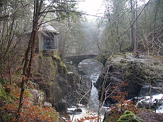
The Hermitage Bridge is an ancient, single-arch stone pedestrian bridge crossing the River Braan near Dunkeld, Perth and Kinross, Scotland. A Category A listed structure, it is in the bounds of The Hermitage, a National Trust for Scotland-protected site. The bridge should not be confused with the Rumbling Bridge, which carries motorised traffic, about 0.62 miles (1.00 km) to the southwest.
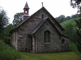
Fincastle Chapel, also known as Glenfincastle Chapel, is a former church building in Glen Fincastle, 2.6 mi (4.2 km) south of Blair Atholl, Perth and Kinross, Scotland. It is named for the glen in which it stands.

 An aerial ropeway spanning the river, approximately halfway along its course, provides a resident easy access to their cottage (2000)
 A footbridge across the river


