
James Hutton was a Scottish geologist, agriculturalist, chemical manufacturer, naturalist and physician. Often referred to as the "Father of Modern Geology," he played a key role in establishing geology as a modern science.

Uniformitarianism, also known as the Doctrine of Uniformity or the Uniformitarian Principle, is the assumption that the same natural laws and processes that operate in our present-day scientific observations have always operated in the universe in the past and apply everywhere in the universe. It refers to invariance in the metaphysical principles underpinning science, such as the constancy of cause and effect throughout space-time, but has also been used to describe spatiotemporal invariance of physical laws. Though an unprovable postulate that cannot be verified using the scientific method, some consider that uniformitarianism should be a required first principle in scientific research. Other scientists disagree and consider that nature is not absolutely uniform, even though it does exhibit certain regularities.

Perthshire, officially the County of Perth, is a historic county and registration county in central Scotland. Geographically it extends from Strathmore in the east, to the Pass of Drumochter in the north, Rannoch Moor and Ben Lui in the west, and Aberfoyle in the south; it borders the counties of Inverness-shire and Aberdeenshire to the north, Angus to the east, Fife, Kinross-shire, Clackmannanshire, Stirlingshire and Dunbartonshire to the south and Argyllshire to the west.

Migmatite is a composite rock found in medium and high-grade metamorphic environments, commonly within Precambrian cratonic blocks. It consists of two or more constituents often layered repetitively: one layer is an older metamorphic rock that was reconstituted subsequently by partial melting ("paleosome"), while the alternate layer has a pegmatitic, aplitic, granitic or generally plutonic appearance ("neosome"). Commonly, migmatites occur below deformed metamorphic rocks that represent the base of eroded mountain chains.

Blair Atholl is a village in Perthshire, Scotland, built about the confluence of the Rivers Tilt and Garry in one of the few areas of flat land in the midst of the Grampian Mountains. The Gaelic place-name Blair, from blàr, 'field, plain', refers to this location. Atholl, which means 'new Ireland', from the archaic Ath Fhodla is the name of the surrounding district.

Lugnaquilla is the highest of the Wicklow Mountains in Ireland, rising to 925 metres (3,035 ft). It is also the highest Irish mountain outside of County Kerry, and the highest point in County Wicklow and the province of Leinster. Lugnaquilla overlooks the Glen of Imaal to the west and Glenmalure to the east.

John Murray, 4th Duke of Atholl, KT, PC, FRS, styled Marquess of Tullibardine from 1764 to 1774, was a Scottish peer.
Plutonism is the geologic theory that the igneous rocks forming the Earth originated from intrusive magmatic activity, with a continuing gradual process of weathering and erosion wearing away rocks, which were then deposited on the sea bed, re-formed into layers of sedimentary rock by heat and pressure, and raised again. It proposes that basalt is solidified molten magma. The theory lead to plutonic (intrinsic) rock classification, which includes intrinsic igneous rocks such as gabbro, diorite, granite and pegmatite. The name plutonism references Pluto, the classical ruler of the underworld and the Roman god of wealth. A main reason Pluto was incorporated into the classification was due to the plutonic rocks commonly being present in gold and silver ore deposits (veins).

The geology of Scotland is unusually varied for a country of its size, with a large number of different geological features. There are three main geographical sub-divisions: the Highlands and Islands is a diverse area which lies to the north and west of the Highland Boundary Fault; the Central Lowlands is a rift valley mainly comprising Palaeozoic formations; and the Southern Uplands, which lie south of the Southern Uplands Fault, are largely composed of Silurian deposits.

Powerscourt Waterfall is the second highest waterfall in Ireland at 121 metres (397 ft) high, it is located at the base of Glensoulan on the River Dargle near Enniskerry, County Wicklow.

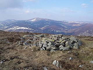
Beinn a’ Ghlò is a Scottish mountain situated roughly 10 km (6 mi) north east of Blair Atholl in the Forest of Atholl in between Glen Tilt and Glen Loch, in Cairngorms National Park.

Glen Roy in the Lochaber area of the Highlands of Scotland is a glen noted for the geological phenomenon of three loch terraces known as the Parallel Roads of Glen Roy. The terraces formed along the shorelines of an ancient ice-dammed loch that existed during a brief period of climatic deterioration, during a much longer period of deglaciation, subsequent to the last main ice age. From a distance they resemble man-made roads running along the side of the glen, hence the name. Much of the glen is designated as a national nature reserve.

Càrn a' Chlamain is a Scottish mountain situated roughly 12 kilometres north of Blair Atholl in the Forest of Atholl. It is the highest point of an undulating plateau lying northeast of Glen Tilt. The River Tarf, a tributary of the Tilt, rises on the northwestern slopes before curving round the northern side of the plateau, whilst a further Tilt tributary marks the plateau's western boundary.
Glen Lui from Gleann Laoigh – calves' glen – Gordon (1925) is one of the major glens on the Mar Lodge Estate, in Aberdeenshire, Scotland.
Mar Lodge Estate is the largest remnant of the ancient Earldom of Mar in Aberdeenshire, Scotland and is now owned by the National Trust for Scotland.
Hutton's Unconformity is a name given to various notable geological sites in Scotland identified by the 18th-century Scottish geologist James Hutton as places where the junction between two types of rock formations can be seen. This geological phenomenon marks the location where rock formations created at different times and by different processes adjoin. For Hutton, such an unconformity provided evidence for his Plutonist theories of uniformitarianism and the age of Earth.
Glas Tulaichean is a large, complex mountain in the Mounth, Scotland. It is about 18 kilometres (11 mi) south of Braemar in Perth and Kinross. It is the highest of a group of domed hills which lie in remote land between the head of Glen Tilt and Glen Shee to the east. It is most commonly climbed from the Spittal of Glenshee via Glen Lochsie to the south.

The River Garry is a major tributary of the River Tummel, itself a tributary of the River Tay, in the traditional county of Perthshire in the Scottish Highlands. It emerges from the northeastern end of Loch Garry (56.8193°N 4.2311°W), just to the southeast of the Pass of Drumochter, and flows southeastwards and eastwards down Glen Garry to the narrow Pass of Killiecrankie beyond which it joins the Tummel (56.7182°N 3.7790°W).
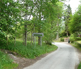
Bridge of Tilt is a village in Perthshire, Scotland, built around the River Tilt, near its confluence with the River Garry. It is 5+3⁄4 miles northwest of Pitlochry. The newer part of the village is continuous with Blair Atholl, only separated by the River Tilt. The village is located primarily on the B8079 between Pitlochry and Dunalastair Water, but the older part of the village is located further up the River Tilt. The A9 runs past the River Garry to the south of Bridge of Tilt, and connects the village with Newtonmore and Inverness in the north and Pitlochry, Perth and Stirling in the south.
This article describes the geology of the Cairngorms National Park, an area in the Highlands of Scotland designated as a national park in 2003 and extended in 2010. The Cairngorms National Park extends across a much wider area than the Cairngorms massif itself and hence displays rather more varied geology.
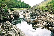 Hutton's Locality. It was from the Dail-an-eas bridge which used to span the river at this point that James Hutton found the evidence he was seeking that molten granite had intruded the country rocks. Location: 56°51′04″N3°44′31″W / 56.851082°N 3.741822°W
 Hutton's Glen Tilt geological exposure at collapsed Dail-an-eas Bridge upstream from Forest Lodge, drawn by John Clerk of Eldin in 1785. Location: 56°51′04″N3°44′30″W / 56.8511°N 3.7418°W
 Watercolour image by John Clerk of Eldin of the key exposure at Glen Tilt. The flow direction of the river is towards the top of the image, in a southwesterly direction. The rectangular areas at the top of the image are the foundations of the collapsed bridge. [9]
 1844 watercolour of Glen Tilt by William Leighton Leitch
 George Washington Wilson's August 1885 photograph of the Glen Tilt looking upstream toward Forest Lodge


