Unemployment in Scotland measured by the Office for National Statistics show unemployment in Scotland at 155,000 (5.6%) as of August 2015. [1]
Unemployment in Scotland measured by the Office for National Statistics show unemployment in Scotland at 155,000 (5.6%) as of August 2015. [1]
| Category | Population | % |
|---|---|---|
| Total population | 5,466,000 | - |
| Population aged 16–64 | 3,493,100 | 63.9 |
| Job density | 2,866,000 | 82 |
| Category | Population | % |
|---|---|---|
| Economically active | 2,763,000 | 78.6% |
| Employed | 2,641,000 | 74.3% |
| Unemployed | 121,000 | 4.4% |
| Jobseeker's Allowance (JSA) (claimant count) | 161,671 | 5.1% |
| Economically inactive | 760,000 | 22.2% |
| Category | Scotland | Scotland (%) | United Kingdom | United Kingdom (%) |
|---|---|---|---|---|
| Total | 826,700 | 24.1 | 8,991,700 | 21.8 |
| Student | 214,200 | 25.9 | 2,561,600 | 28.5 |
| Looking After Family/Home | 140,200 | 17.0 | 1,731,600 | 19.3 |
| Temporary Sick | 16,900 | 2.0 | 178,900 | 2.0 |
| Long-Term Sick | 245,200 | 29.7 | 2,170,200 | 24.1 |
| Discouraged | 9,300 | 1.1 | 70,200 | 0.8 |
| Retired | 121,000 | 14.6 | 1,210,500 | 13.5 |
| Other | 80,000 | 9.7 | 1,068,800 | 11.9 |
| Wants A Job | 156,600 | 18.9 | 1,857,500 | 20.7 |
| Does Not Want A Job | 670,100 | 81.1 | 7,134,200 | 79.3 |
| Category | Scotland | Scotland (%) | United Kingdom | United Kingdom (%) |
|---|---|---|---|---|
| NVQ4 And Above | 1,678,400 | 49.0 | 17,732,200 | 43.0 |
| NVQ3 | 443,500 | 12.9 | 6,927,400 | 16.8 |
| Trade Apprenticeships | 122,300 | 3.6 | 1,157,900 | 2.8 |
| NVQ2 | 470,900 | 13.7 | 6,373,000 | 15.4 |
| NVQ1 | 238,900 | 7.0 | 3,968,300 | 9.6 |
| Other Qualifications | 196,500 | 5.7 | 2,389,700 | 5.8 |
| No Qualifications | 276,500 | 8.1 | 2,721,300 | 6.6 |
| NVQ4 And Above | 1,678,400 | 49.0 | 17,732,200 | 43.0 |
| NVQ3 And Above | 2,183,000 | 63.7 | 25,238,500 | 61.2 |
| NVQ2 And Above | 2,715,100 | 79.2 | 32,190,500 | 78.0 |
| NVQ1 And Above | 2,954,000 | 86.2 | 36,158,800 | 87.6 |
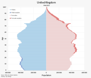
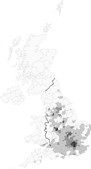
The population of the United Kingdom was estimated at almost 67.6 million people in 2022. It is the 21st most populated country in the world and has a population density of 279 people per square kilometre, with England having significantly greater density than Wales, Scotland, and Northern Ireland. Almost a third of the population lives in south east England, which is predominantly urban and suburban, with 8.9 million in the capital city, London, whose population density was 5,640 inhabitants per square kilometre (14,600/sq mi) in 2022.

Unemployment, according to the OECD, is people above a specified age not being in paid employment or self-employment but currently available for work during the reference period.

Brondesbury, which includes Brondesbury Park, is an area in the London Borough of Brent, in London, England. The area is traditionally part of the Ancient Parish and subsequent Municipal Borough of Willesden, one of the areas that merged to form the modern borough of Brent.

The demography of England has since 1801 been measured by the decennial national census, and is marked by centuries of population growth and urbanization. Due to the lack of authoritative contemporary sources, estimates of the population of England for dates prior to the first census in 1801 vary considerably. The population of England at the 2021 census was about 56,489,800.
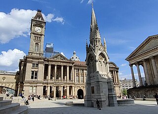
The economy of Birmingham is an important manufacturing and engineering centre, employing over 100,000 people in the industry and contributing billions of pounds to the national economy. During 2013, the West Midlands region as a whole created UK exports in goods worth £19.6 billion, around 8.73% of the national total.

Bury South is a borough constituency represented in the House of Commons of the Parliament of the United Kingdom. At the 2019 General Election it was the 10th most marginal seat in the country, with a majority of 402 for the Conservative Party candidate Christian Wakeford. Wakeford defected to the Labour Party on 19 January 2022.

Birmingham Ladywood is a constituency of part of the city of Birmingham, represented in the House of Commons since 2010 by Shabana Mahmood of the Labour Party.

Brentford and Isleworth is a constituency represented in the House of Commons of the UK Parliament. It forms the eastern part of the London Borough of Hounslow. Since 2015, it has been represented by Ruth Cadbury of the Labour Party.
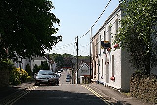
Gowerton is a large village and community, about 4 miles (6 km) north west of Swansea city centre, Wales. Gowerton is often known as the gateway to the Gower Peninsula. Gowerton's original name was Ffosfelin. The village falls within the Gowerton electoral ward of the City and County of Swansea Council, which elects one councillor. The community had a population of 5,212 and the built-up area with Waunarlwydd 8,183.

The demography of London is analysed by the Office for National Statistics and data is produced for each of the Greater London wards, the City of London and the 32 London boroughs, the Inner London and Outer London statistical sub-regions, each of the Parliamentary constituencies in London, and for all of Greater London as a whole. Additionally, data is produced for the Greater London Urban Area. Statistical information is produced about the size and geographical breakdown of the population, the number of people entering and leaving country and the number of people in each demographic subgroup. The total population of London as of 2021 is 8,799,800.
Mixed is an ethnic group category that was first introduced by the United Kingdom's Office for National Statistics for the 2001 Census. Colloquially, it refers to British citizens or residents whose parents are of two or more races or ethnic backgrounds. The Mixed or Multiple ethnic group numbered just under 1.8 million in the 2021 United Kingdom census or 2.7% of the total UK population.

The demography of Birmingham, England, is analysed by the Office for National Statistics and data produced for each of the wards that make up the city, and the overall city itself, which is the largest city proper in England as well as the core of the third most populous urban area, the West Midlands conurbation.
A census of the population of the United Kingdom is taken every ten years. The 2011 census was held in all counties of the UK on 27 March 2011. It was the first UK census which could be completed online via the Internet. The Office for National Statistics (ONS) is responsible for the census in England and Wales, the General Register Office for Scotland (GROS) is responsible for the census in Scotland, and the Northern Ireland Statistics and Research Agency (NISRA) is responsible for the census in Northern Ireland.
The Annual Population Survey (APS) is a combined statistical survey of households in Great Britain which is conducted quarterly by the Office for National Statistics (ONS). It combines results from the Labour Force Survey (LFS) and the English, Welsh and Scottish Labour Force Survey boosts which are funded by the Department for Education and Skills (DfES), the Department for Work and Pensions (DWP), the Welsh Government and the Scottish Government.

Unemployment in the United Kingdom is measured by the Office for National Statistics. As of February 2024, the U.K. unemployment rate is 3.8%, down from 3.9% in January.

Cadfarch is a community a few miles to the south and southeast of Machynlleth in Powys in Wales. The community's western and southern border is with the neighbouring county of Ceredigion, while the northwest corner touches Gwynedd.

Shobnall is a settlement and civil parish located in Staffordshire, England. It covers an area located in the west of Burton upon Trent. The population of Shobnall taken at the 2011 census was 5,071.

The Wrexham Built-up area is an area of land defined by the United Kingdom Office for National Statistics (ONS) for population monitoring purposes. It is an urban conurbation fully within Wrexham County Borough and consists of the urban area centred on the city of Wrexham. Until the 2021 census, it also included the historically industrial settlements to the west including Gwersyllt, Rhostyllen, Brymbo, Bradley and New Broughton.
Demography of the Tees Valley or Teesside metropolitan area of England is recorded with differing definitions. The area's fragmented data into different area definintions every other census after 1971 has meant a lack of clear lineal correlation analysis and anachronistic data.
| Companies | |||||
|---|---|---|---|---|---|
| Finance | |||||
| Banking |
| ||||
| Policy | |||||
| Localised | |||||
| People and labour |
| ||||
| Sectors |
| ||||
| Theory |
| ||||