| Riverview Park | |
|---|---|
 | |
 | |
| Location | San Jose, California |
| Coordinates | 37°24′21″N121°56′29″W / 37.4058°N 121.9415°W |
| Area | 5.2 acres (2.1 ha) [1] |
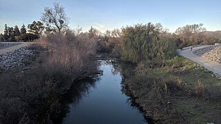
Riverview Park is a park in San Jose, California, located along the Guadalupe River in North San Jose.
| Riverview Park | |
|---|---|
| | |
| | |
| Location | San Jose, California |
| Coordinates | 37°24′21″N121°56′29″W / 37.4058°N 121.9415°W |
| Area | 5.2 acres (2.1 ha) [1] |
Riverview Park is a park in San Jose, California, located along the Guadalupe River in North San Jose.

The park was laid out and dedicated in 2015. [2] [3]
A pedestrian bridge connects the park to the historic James Lick Mansion across the Guadalupe River, the 19th century estate built by local land baron James Lick who was the wealthiest man in California, at the time of his death in 1870. [4]
Riverview Park is a large riverside park located on the eastern bank of the Guadalupe River, in North San Jose.
The Guadalupe River Trail passes along the park's edge with the river.
It is located within walking distance of the River Oaks station on the VTA light rail.
San Jose, officially San José, is the cultural, financial, and political center of Silicon Valley and the largest city in Northern California, by both population and area.

Northern California is a geographic and cultural region that generally comprises the northern portion of the U.S. state of California. Spanning the state's northernmost 48 counties, its main population centers include the San Francisco Bay Area, the Greater Sacramento area, and the Metropolitan Fresno area. Northern California also contains redwood forests, along with the Sierra Nevada, including Yosemite Valley and part of Lake Tahoe, Mount Shasta, and most of the Central Valley, one of the world's most productive agricultural regions.

James Lick was an American real estate investor, carpenter, piano builder, land baron, and patron of the sciences. At the time of his death, he was the wealthiest man in California, and left the majority of his estate to social and scientific causes.

Noe Valley is a neighborhood in the central part of San Francisco, California.
Interstate 280 (I-280) is a 57.5-mile-long (92.5 km) north–south auxiliary Interstate Highway in the San Francisco Bay Area of Northern California. It runs from I-680 and US 101 in San Jose to King and Fifth Streets in San Francisco, running just to the west of the larger cities of San Francisco Peninsula for most of its route.

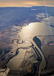
The Guadalupe River mainstem is an urban, northward flowing 14 miles (23 km) river in California whose much longer headwater creeks originate in the Santa Cruz Mountains. The river mainstem now begins on the Santa Clara Valley floor when Los Alamitos Creek exits Lake Almaden and joins Guadalupe Creek just downstream of Coleman Road in San Jose, California. From here it flows north through San Jose, where it receives Los Gatos Creek, a major tributary. The Guadalupe River serves as the eastern boundary of the City of Santa Clara and the western boundary of Alviso, and after coursing through San José, it empties into south San Francisco Bay at the Alviso Slough.

State Route 87, locally called the Guadalupe Freeway, is a north–south state highway in San Jose, California, United States. Before being upgraded to a freeway, it was Guadalupe Parkway.

Sonoma Valley is a valley located in southeastern Sonoma County, California, in the San Francisco Bay Area. Known as the birthplace of the California wine industry, the valley is home to some of the earliest vineyards and wineries in the state, some of which survived the phylloxera epidemic of the 1870s and the impact of prohibition in the early 20th century. Today, the valley's wines are protected by the U.S. Federal Government's Sonoma Valley and Carneros AVAs.
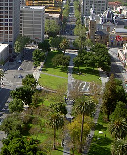
The Plaza de César Chávez is an urban plaza and park in Downtown San Jose, California, in Silicon Valley. The plaza's origins date to 1797 as the plaza mayor of the Spanish Pueblo de San José de Guadalupe, making it the oldest public space in Northern California. The plaza was reconsecrated after Californian civil rights activist César Chávez in 1993.
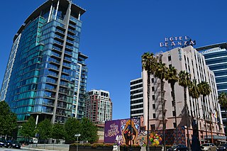
Downtown San Jose is the central business district of San Jose, California, in Silicon Valley. It is the largest urban center of Silicon Valley. Downtown is one of the largest tech clusters in Silicon Valley, as well as the cultural and political center of San Jose.

San Antonio Missions National Historical Park is a National Historical Park and part of a UNESCO World Heritage Site preserving four of the five Spanish frontier missions in San Antonio, Texas, USA. These outposts were established by Catholic religious orders to spread Christianity among the local natives. These missions formed part of a colonization system that stretched across the Spanish Southwest in the 17th, 18th, and 19th centuries.
Coyote Creek is a river that flows through the Santa Clara Valley in California, United States.

The Alameda is an alameda and historic district in San Jose, California, west of Downtown San Jose.

The Green Line is a light rail in Santa Clara County, California, and part of the Santa Clara Valley Transportation Authority (VTA) light rail system. It serves 26 stations in the cities of Santa Clara, San Jose, and Campbell, traveling between Old Ironsides and Winchester stations. The line connects Levi's Stadium, San Jose International Airport, Downtown San Jose, San Jose State University, SAP Center, and Diridon station. It runs for 20 hours per day on weekdays, with headways of 15 minutes for most of the day. On weekends, train run at 20 minute headways for most of the day. After around 8pm on weekdays and weekends trains run at 30 minute headways.
U.S. Route 101 (US 101) is a major north–south United States Numbered Highway, stretching from Los Angeles, California to Tumwater, Washington. The California portion of US 101 is one of the last remaining and longest U.S. Routes still active in the state, and the longest highway of any kind in California. US 101 was also one of the original national routes established in 1926. Significant portions of US 101 between the Los Angeles area and the San Francisco Bay Area follow El Camino Real, the historic road connecting the former Alta California's 21 missions.

The Los Gatos Creek runs 24 miles (39 km) in California through Santa Clara Valley Water District's Guadalupe Watershed from the Santa Cruz Mountains northward through the Santa Clara Valley until its confluence with the Guadalupe River in downtown San Jose. The Guadalupe River then continues onward into San Francisco Bay.
The Guadalupe River Trail is an 11-mile (18 km) pedestrian and bicycle path in the city of San Jose, California. The path runs along the banks of the Guadalupe River. The trail is currently composed of two discontinuous segments: a short segment along the Upper Guadalupe River and a longer segment along the Lower Guadalupe River. This trail is heavily used for both recreation and commuting, as it provides direct access to Downtown San Jose from many of the outlying neighborhoods. The trail is paved.

Rancho Los Feliz was a 6,647-acre (26.90 km2) Spanish land concession in present-day Los Angeles County, California given in 1795 by Spanish Governor Pedro Fages to José Vicente Feliz. The land of the grant includes Los Feliz and Griffith Park, and was bounded on the east by the Los Angeles River.
Rancho Ulistac was a 2,217-acre (8.97 km2) Mexican land grant in present-day Santa Clara County, California, given in 1845 by Governor Pío Pico to Marcello and Cristobal, Indians. The grant extended across lowlands reaching from the Alviso shoreline southward and encompassing the land between the Guadalupe River and Saratoga Creek, and the town of Agnew.

Alamitos Creek or Los Alamitos Creek is a 7.7-mile-long (12.4 km) creek in San Jose, California, which becomes the Guadalupe River when it exits Lake Almaden and joins Guadalupe Creek. Los Alamitos Creek is located in Almaden Valley and originates from the Los Capitancillos Ridge and the Santa Cruz Mountains. This creek flows through the Valley's Guadalupe Watershed, which is owned by the Santa Clara Valley Water District. The creek flows in a generally northwesterly direction after rounding the Los Capitancillos Ridge and the town of New Almaden, in the southwest corner, before ambling along the Santa Teresa Hills on northeast side of the Almaden Valley. Its environment has some relatively undisturbed areas and considerable lengths of suburban residential character. Originally called Arroyo de los Alamitos, the creek's name is derived from "little poplar", "alamo" being the Spanish word for "poplar" or "cottonwood".
| Wikimedia Commons has media related to Riverview Park (San Jose) . |
| This San Jose, California-related article is a stub. You can help Wikipedia by expanding it. |