Lake County is a county located in the north central portion of the U.S. state of California. As of the 2020 census, the population was 68,163. The county seat is Lakeport. The county takes its name from Clear Lake, the dominant geographic feature in the county and the largest non-extinct natural lake wholly within California.

Kelseyville is a census-designated place (CDP) in Lake County, California, United States. Kelseyville is located six miles southeast of Lakeport, at an elevation of 1,384 feet. The population was 3,382 according to the 2020 United States census.
Nassau Bay is a city in Harris County, Texas, United States, bordering the outermost southeastern edge of the city of Houston. It is located in the Clear Lake Area near Galveston Bay, directly adjacent to the Lyndon B. Johnson Space Center. The population was 5,347 at the 2020 census.

Taupō, sometimes written Taupo, is a town located in the central North Island of New Zealand. It is situated on the edge of Lake Taupō, which is the largest freshwater lake in New Zealand. Taupō was constituted as a borough in 1953. It has been the seat of Taupō District Council since the council was formed in 1989.
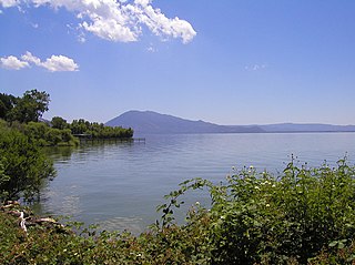
Clear Lake is a natural freshwater lake in Lake County in the U.S. state of California, north of Napa County and San Francisco. It is the largest natural freshwater lake wholly within the state, with 68 square miles (180 km2) of surface area. At an age of 0.5 million years, it is the oldest lake in North America. It is the latest lake to occupy a site with a history of lakes stretching back at least 2,500,000 years.

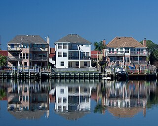
Clear Lake City is a master-planned community located in southeast Harris County, Texas, within the Bay Area of Greater Houston. It is the second-largest master-planned community in Houston – behind Kingwood. The majority of the community lies in the corporate limits of Houston, and a small eastern portion within the city limits of Taylor Lake Village.

Onondaga Lake is located in Central New York, immediately northwest of and adjacent to Syracuse, New York. The southeastern end of the lake and the southwestern shore abut industrial areas and expressways; the northeastern shore and northwestern end border a series of parks and museums.

Strathcona County is a specialized municipality in the Edmonton Metropolitan Region within Alberta, Canada between Edmonton and Elk Island National Park. It forms part of Census Division No. 11.
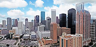
The geographic areas of Houston are generally classified as either being inside or outside Interstate 610, colloquially called "the Loop". The Loop generally encircles the central business district and the "island cities" of West University Place, Southside Place, and a portion of Bellaire.

Mount Konocti is a volcano in Lake County, California on the south shore of Clear Lake. At 4,305 feet (1,312 m), it is the second highest peak in the Clear Lake Volcanic Field, which consists of numerous volcanic domes and cones ranging from 10,000 to 2.1 million years old. Although it is often described as extinct, it is actually classified by the USGS as High Threat Potential. Clear Lake Volcanic Field's alert level is currently classified as Normal.

State Route 281 is an approximately 3-mile (4.8 km) state highway in the U.S. state of California that runs along Soda Bay Road from near the southern shore of Clear Lake to State Route 29 in Glenview in Lake County. SR 281 is legislatively defined to be a loop route of SR 29 that runs along or near the southern edge of Clear Lake from Glenview to Lakeport, but most of this is unconstructed.

The 2006 Ivory Coast toxic waste dump was a health crisis in Ivory Coast in which a ship registered in Panama, the Probo Koala, chartered by the Singaporean-based oil and commodity shipping company Trafigura Beheer BV, offloaded toxic waste to an Ivorian waste handling company which disposed of it at the port of Abidjan. The local contractor, a company called Tommy, dumped the waste at 12 sites in and around the city in August 2006. The dumping, which took place against a backdrop of instability in Abidjan as a result of the country's first civil war, allegedly led to the death of 7 and 20 hospitalisations, with a further 26,000 people treated for symptoms of poisoning.
The Laguna Lake Development Authority (LLDA), one of the attached agencies of the Department of Environment and Natural Resources (DENR), is responsible for the preservation, development, and sustainability of Laguna de Bay and its 21 major tributary rivers.

Lake State Railway is a railroad operating in the Saginaw Valley and northeastern quadrant of the Lower Peninsula of Michigan. The railroad moves large quantities of aggregate and limestone, as well as coal, grain, and chemical products. Some of the company's largest customers include Dow Chemical Company, S. C. Johnson & Son, Lafarge, ConAgra Foods, Archer Daniels Midland, Conrad Yelvington Distributors, and Consumers Energy.

Forest Lake Resort was a resort in the Cobb Mountain area of Lake County, California, in an area of wet meadows along Kelsey Creek. Originally a campground, it was developed into a resort in the 1930s to exploit the growing automobile-based recreation market. The resort was sold in 1963. By 1989 it was longer operational, and was being considered for development as a community park site.

Seigler Springs is a set of springs in Lake County, California around which a resort developed in the 19th century. In the 1930s the resort was expanded, and in 1947 an airport opened nearby. The resort declined in the 1960s. Part of it was separated out and became a residential subdivision, while part became a religious retreat. The 2015 Valley Fire caused great damage.

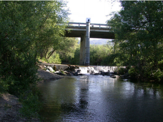
Scotts Creek is a stream in Lake County, California, the largest tributary of Clear Lake. It rises to the south of Cow Mountain in the Mayacamas Mountains, then flows southeast towards Clear Lake, running through the fertile Scotts Valley and the seasonal Tule Lake before joining Middle Creek and flowing into the lake via Rodman Slough.
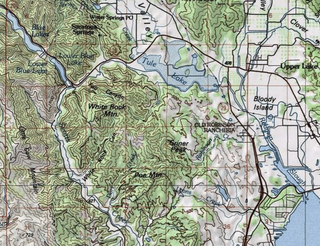
Tule Lake is a seasonal lake in Lake County, California. It is named after the edible bullrushes, or tules, that used to surround the lake. These have been cleared and the lake partly drained to support agriculture, but it still floods every winter. In summer it is used for growing wild rice and grazing cattle. There have been proposals to restore the lake to its original wetlands condition.
Middle Creek is a creek that drains through Rodman Slough into Clear Lake in Lake County, California. It supplies 21% of the streamflow to Clear Lake. The watershed vegetation has been drastically modified by European settlers through sheep and cattle grazing, logging and farming in the valley floors. The creek once flowed through extensive wetlands at its mouth, but these were mainly drained to create farmland, apart from Rodman Slough on the west side. There are now projects to restore the drained land to its original condition.
Riviera Heights is a planned and unincorporated community in Lake County, California, lying within the Soda Bay census-designated place boundaries. It is located on the northern slope of Mount Konocti, below Buckingham Peak, on the south shore of Clear Lake. It lies east of the Soda Bay neighborhood proper, and west of Buckingham Park.


