Alice International Airport is three miles southeast of Alice, in Jim Wells County, Texas. The airport is owned by the city and county. The National Plan of Integrated Airport Systems for 2011–2015 categorized it as a general aviation facility.

Anniston Regional Airport, formerly known as Anniston Metropolitan Airport, is a city-owned public-use airport located five nautical miles southwest of the central business district of Anniston, a city in Calhoun County, Alabama, United States. It is included in the National Plan of Integrated Airport Systems for 2011–2015, which categorized it as a general aviation airport.
Pittsfield Municipal Airport is two miles west of Pittsfield, in Berkshire County, Massachusetts. The National Plan of Integrated Airport Systems for 2011–2015 categorized it as a general aviation facility.
South Jersey Regional Airport is a public use airport in Lumberton Township, Burlington County, New Jersey, United States. Owned by the New Jersey Department of Transportation, the airport is located four nautical miles southwest of the central business district of Mount Holly, New Jersey. This facility is included in the National Plan of Integrated Airport Systems for 2011–2015, which categorized it as a general aviation reliever airport.
Talladega Municipal Airport is a city-owned public-use airport located eight nautical miles northeast of the central business district of Talladega, a city in Talladega County, Alabama, adjacent to Talladega Superspeedway in the city of Lincoln. It is included in the FAA's National Plan of Integrated Airport Systems for 2011–2015, which categorized it as a general aviation facility.

Corvallis Municipal Airport is five miles southwest of Corvallis, in Benton County, Oregon. The National Plan of Integrated Airport Systems for 2011–2015 categorized it as a general aviation facility.

Ontario Municipal Airport is three miles west of Ontario, in Malheur County, Oregon. The National Plan of Integrated Airport Systems for 2011–2015 categorized it as a general aviation facility.

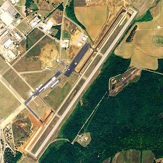
Moton Field Municipal Airport is a public-use airport located three nautical miles north of the central business district of Tuskegee, a city in Macon County, Alabama, United States. The airport is owned by the City of Tuskegee. It is included in the FAA's National Plan of Integrated Airport Systems for 2011–2015, which categorized it as a general aviation facility.
Keokuk Municipal Airport is five miles northwest of Keokuk, in Lee County, Iowa. The National Plan of Integrated Airport Systems for 2017–2021 categorized it as a general aviation facility.

West Woodward Airport is in Woodward County, Oklahoma, United States, seven miles west of Woodward, which owns it. The National Plan of Integrated Airport Systems for 2011–2015 called it a general aviation airport.

Weedon Field is a city-owned, public-use airport located three nautical miles north of the central business district of Eufaula, a city in Barbour County, Alabama, United States.
Port Meadville Airport is a public use airport located three nautical miles west of the central business district of Meadville, in Crawford County, Pennsylvania, United States. It is included in the FAA's National Plan of Integrated Airport Systems for 2011–2015, which categorized it as a general aviation facility.

Dexter B. Florence Memorial Field is a city-owned public-use airport located one nautical mile south of the central business district of Arkadelphia, a city in Clark County, Arkansas, United States.
South Lewis County Airport, also known as Ed Carlson Memorial Field, is a county-owned public-use airport in Lewis County, Washington, United States. It is located three nautical miles north of the central business district of Toledo, Washington.
Z. M. Jack Stell Field is a city-owned public-use airport located five nautical miles northeast of the central business district of Crossett, in Ashley County, Arkansas, United States.

Manila Municipal Airport is a public-use airport located two nautical miles northeast of the central business district of Manila, in Mississippi County, Arkansas, United States. It is owned by the City of Manila.

Blytheville Municipal Airport is a public use airport located three nautical miles east of the central business district of Blytheville, in Mississippi County, Arkansas, United States. It is owned by the City of Blytheville.
Fayetteville Municipal Airport is a public use airport located six nautical miles south of the central business district of Fayetteville, a city in Lincoln County, Tennessee, United States, in the community of Park City. It is owned by the Fayetteville-Lincoln Airport Authority. It is included in the National Plan of Integrated Airport Systems for 2011–2015, which categorized it as a general aviation airport.
Mission Field is a public use airport located five nautical miles east of the central business district of Livingston, a city in Park County, Montana, United States. It is owned by the city and county. This airport is included in the National Plan of Integrated Airport Systems for 2011–2015, which categorized it as a general aviation facility.
East Georgia Regional is a city/county-owned public-use airport in Swainsboro, Emanuel County, United States. The airport is located 2 nautical miles (4 km) southeast of the central business district of Swainsboro, Georgia. This airport is included in the National Plan of Integrated Airport Systems for 2011–2015, which categorized it as a general aviation facility.
