
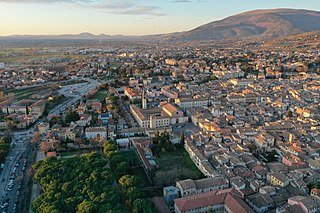
Perugia is the capital city of Umbria in central Italy, crossed by the River Tiber. The city is located about 164 km (102 mi) north of Rome and 148 km (92 mi) southeast of Florence. It covers a high hilltop and part of the valleys around the area.

Gualdo Tadino is an ancient town of Italy, in the province of Perugia in northeastern Umbria, on the lower flanks of Monte Penna, a mountain of the Apennines. It is 47 kilometres (29 mi) NE of Perugia.
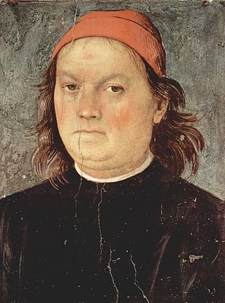
Pietro Perugino, an Italian Renaissance painter of the Umbrian school, developed some of the qualities that found classic expression in the High Renaissance. Raphael became his most famous pupil.
Foligno is an ancient town of Italy in the province of Perugia in east central Umbria, on the Topino river where it leaves the Apennines and enters the wide plain of the Clitunno river system. It is located 40 kilometres south-east of Perugia, 10 km (6 mi) north-north-west of Trevi and 6 km (4 mi) south of Spello.

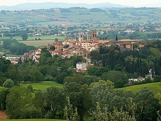
Spello is an ancient town and comune (township) of Italy, in the province of Perugia in eastern-central Umbria, on the lower southern flank of Monte Subasio. It is 6 km (4 mi) NNW of Foligno and 10 km (6 mi) SSE of Assisi. It is one of I Borghi più belli d'Italia.
Deruta is a hill town and comune in the Province of Perugia in the Umbria region of central Italy. Long known as a center of refined maiolica manufacture, Deruta remains known for its ceramics, which are exported worldwide. It is one of I Borghi più belli d'Italia.

Constantius of Perugia is one of the patron saints of Perugia, Italy.

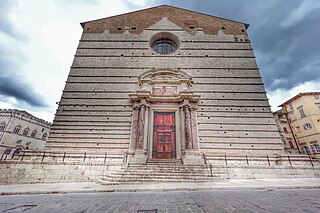
The basilica diSan Pietro is a Catholic basilica and abbey in the Italian city of Perugia. Its bell tower, standing at 70 meters tall, is the tallest structure in Perugia and is one of the city's most significant symbols. It is an Italian national monument

San Giorgio Canavese is a town and comune in the Metropolitan City of Turin in the region of Piedmont, northern Italy.

Fratta Todina is a comune in the Province of Perugia in the Italian region Umbria, located about 30 km south of Perugia.
Vallo di Nera is a comune (municipality) in the Province of Perugia in the Italian region Umbria, located about 60 km southeast of Perugia. It is one of I Borghi più belli d'Italia.
Perugia Cathedral is a Roman Catholic cathedral in Perugia, Umbria, central Italy, dedicated to Saint Lawrence. Formerly the seat of the bishops and archbishops of Perugia, it has been since 1986 the archiepiscopal seat of the Archdiocese of Perugia-Città della Pieve.

Borgo Cerreto is a frazione of the comune of Cerreto di Spoleto in the Province of Perugia, Umbria, central Italy. It stands at an elevation of 357 metres above sea level. At the time of the Istat census of 2001 it had 170 inhabitants.

Ponte is a frazione of the comune of Cerreto di Spoleto in the Province of Perugia, Umbria, central Italy. It stands at an elevation of 441 metres above sea level. At the time of the Istat census of 2001 it had 125 inhabitants.

Moiano is a frazione of the comune of Città della Pieve in the Province of Perugia, Umbria, central Italy. It stands at an elevation of 261 metres above sea level. At the time of the Istat census of 2001 it had 815 inhabitants.
San Mariano is a village of the municipality of Corciano in the Province of Perugia, Umbria, central Italy. It stands at an elevation of 315 metres above sea level and was named for San Mariano. The village lies over three hills: the first with a castle, the second with a cemetery and the third near the place called "La Badia." From the top of the hills can be seen San Sisto and Lacugnana Hill eastwards, the plane of Castel del Piano to the south, Solomeo towards the west and the villages of Ellera and Olmo northwards. Notable monuments are the old castle, the medieval church and the monument dedicated to the soldiers of the 1st world war. Just next to the parish church is the Rachel Marro public gardens fitted with benches in the middle of some thriving olive trees. In a corner of the gardens there is a memorial stone with the carved names of those who gave their lives during the two world wars. At the time of the Istat census of 2001 it had 1152 inhabitants. San Mariano is connected by bus routes with the city of Perugia. During recent years it has developed many commercial activities such as malls and cinemas built in the plane near the village.

San Domenico is a Roman Catholic basilica church, located on Piazza Giordano Bruno and via del Castellano in the city of Perugia, region of Umbria, central Italy.
The following is a timeline of the history of the city of Perugia in the Umbria region of Italy.

Chiesa di San Prospero is a church in Perugia, Italy, located in Via San Prospero, 7, which dates back to the 7th and 8th centuries. It is located in the Porta Eburnea district outside the city walls. It is of importance for art history because it preserves the oldest frescoes in Perugia, dating to 1225.


 church Madonna del Verde
 defensive gate of entrance
 church San Nicola at the cemetery
 church San Giacomo in the fortified center


