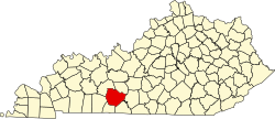
Rockfield is an unincorporated community in Warren County, in the U.S. state of Kentucky. [1]
Warren County is a county located in the U.S. state of Kentucky. As of 2014, the population was 120,460, making it the fifth-most populous county in Kentucky. The county seat is Bowling Green. Generally the county is dry, prohibiting the sale of alcohol, but retail alcohol sales are allowed in the "wet city" of Bowling Green; Warren County is classified as a moist county.
In the United States, a state is a constituent political entity, of which there are currently 50. Bound together in a political union, each state holds governmental jurisdiction over a separate and defined geographic territory and shares its sovereignty with the federal government. Due to this shared sovereignty, Americans are citizens both of the federal republic and of the state in which they reside. State citizenship and residency are flexible, and no government approval is required to move between states, except for persons restricted by certain types of court orders. Four states use the term commonwealth rather than state in their full official names.
Kentucky, officially the Commonwealth of Kentucky, is a state located in the east south-central region of the United States. Although styled as the "State of Kentucky" in the law creating it, (because in Kentucky's first constitution, the name state was used) Kentucky is one of four U.S. states constituted as a commonwealth. Originally a part of Virginia, in 1792 Kentucky became the 15th state to join the Union. Kentucky is the 37th most extensive and the 26th most populous of the 50 United States.
A post office called Rockfield has been in operation since 1866. [2] The community was named for the rocky terrain near the original town site. [3]
Simpson County is a county located in the Pennyroyal Plateau region the U.S. state of Kentucky. As of the 2010 census, the population was 17,327. Its county seat is Franklin.
Allen County is a county located in the U.S. state of Kentucky. As of the 2010 census, the population was 19,956. Its county seat is Scottsville. The county is named for Colonel John Allen, a state senator and soldier who was killed leading the 1st Regiment of Kentucky Rifleman at the Battle of Frenchtown, Michigan during the War of 1812. Allen County is a prohibition or completely dry county. It was formed in 1815 from parts of Barren and Warren counties.
Southcentral Kentucky Community and Technical College, located in Bowling Green, in the U.S. state of Kentucky, is one of 16 two-year, open-admissions colleges of the Kentucky Community and Technical College System (KCTCS). The college is accredited by the Southern Association of Colleges and Schools (SACS).
Rockfield is an unincorporated community in Rock Creek Township, Carroll County, Indiana. It is part of the Lafayette, Indiana Metropolitan Statistical Area.
Kentucky Route 242 is a 10.275-mile-long (16.536 km) long east–west state highway located south of the city limits of Bowling Green in rural Warren County, Kentucky. The western terminus of the route is at US 68 and KY 80 northwest of Rockfield. The eastern terminus is at KY 622 south of Plano.
Deedsville is an unincorporated community in Union Township, Miami County, in the U.S. state of Indiana.
Coxheath is an unincorporated community in Marengo County, Alabama, United States. Coxheath had a post office at one time, but it no longer exists.
Cascade is an unincorporated community in Pittsylvania County, in the U.S. state of Virginia.
Lydick is an unincorporated community in Warren Township, St. Joseph County, in the U.S. state of Indiana.
Drakes Creek is a stream in Warren County, Kentucky, in the United States. It is a tributary of the Barren River.
W240CP is a low-powered translator-style radio station licensed to and serving Bowling Green, Kentucky. It is a Contemporary hit radio station that simulcasts a second HD Radio subchannel of parent station WOVO, which is licensed to Horse Cave, but also serves Bowling Green and Glasgow. Known on air as "96 Hits", it broadcasts with a frequency of 95.9 megahertz. The translator's transmitter is located near Rockfield.
Woodland is an unincorporated community in Madison Township, St. Joseph County, in the U.S. state of Indiana.
Richardsville is an unincorporated community in Warren County, in the U.S. state of Kentucky.
Rockland is an unincorporated community in Warren County, in the U.S. state of Kentucky.
Rocky Hill is an unincorporated community in Barren County, in the U.S. state of Kentucky.
Offutt Lake is an unincorporated community in Thurston County, in the U.S. state of Washington.
Grayson is an unincorporated community in Clinton County, in the U.S. state of Missouri.
Gregg is an unincorporated community in Newton County, in the U.S. state of Missouri.
Louisa is an extinct town in southern Texas County, in the U.S. state of Missouri. The community was located along the South Prong of Jacks Fork Creek southeast of Grogan.
Coordinates: 36°54′37″N86°33′52″W / 36.91028°N 86.56444°W
A geographic coordinate system is a coordinate system that enables every location on Earth to be specified by a set of numbers, letters or symbols. The coordinates are often chosen such that one of the numbers represents a vertical position and two or three of the numbers represent a horizontal position; alternatively, a geographic position may be expressed in a combined three-dimensional Cartesian vector. A common choice of coordinates is latitude, longitude and elevation. To specify a location on a plane requires a map projection.
This Warren County, Kentucky state location article is a stub. You can help Wikipedia by expanding it. |