The Ohio River is a 981-mile (1,579 km) long river in the midwestern United States that flows southwesterly from western Pennsylvania south of Lake Erie to its mouth on the Mississippi River at the southern tip of Illinois. It is the second largest river by discharge volume in the United States and the largest tributary by volume of the north-south flowing Mississippi River that divides the eastern from western United States. The river flows through or along the border of six states, and its drainage basin includes parts of 15 states. Through its largest tributary, the Tennessee River, the basin includes several states of the southeastern U.S. It is the source of drinking water for three million people.

Owsley County is a county located in the Eastern Coalfield region of the U.S. state of Kentucky. As of the 2010 census, the population was 4,755, making it the second-least populous county in Kentucky. The county seat is Booneville. The county was organized on January 23, 1843, from Clay, Estill, and Breathitt counties and named for William Owsley (1782–1862), the judge of the Kentucky Court of Appeals and Governor of Kentucky (1844–48).

Estill County is a county located in the U.S. state of Kentucky. As of the 2010 census, the population was 14,672. Its county seat is Irvine The county was formed in 1808 and named for Captain James Estill, a Kentucky militia officer who was killed in the Battle of Little Mountain during the American Revolutionary War. Estill County is a moist county meaning that the county seat, the city of Irvine, allows the sale of alcohol after the October 9, 2013 vote, but not the rest of Estill County outside the Irvine city limits.

Breathitt County is a county located in the eastern Appalachian portion of the U.S. state of Kentucky. As of the 2010 census, the population was 13,878. Its county seat is Jackson, Kentucky. The county was formed in 1839 and was named for John Breathitt, who was Governor of Kentucky from 1832 to 1834. Breathitt County was a prohibition or dry county, until a public vote in July 2016 that allowed alcohol sales.
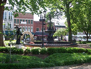
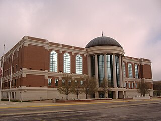
Bowling Green is a home rule-class city and the county seat of Warren County, Kentucky, United States. As of 2017, its population of 67,067 made it the third most-populous city in the state after Louisville and Lexington; its metropolitan area had an estimated population of 165,732; and the combined statistical area it shares with Glasgow has an estimated population of 218,870.
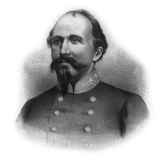
John Hunt Morgan was a Confederate general in the American Civil War.

The Bluegrass region is a geographic region in the U.S. state of Kentucky. It makes up the northern part of the state, roughly bounded by the cities of Frankfort, Paris, Richmond and Stanford. The Bluegrass region is characterized by underlying fossiliferous limestone, dolostone, and shale of the Ordovician geological age. Hills are generally rolling, and the soil is highly fertile for growing pasture. Since the antebellum years, the region has been a center for breeding quality livestock, especially Thoroughbred race horses. Since the late 20th century, the area has become increasingly developed with residential and commercial properties, particularly around Lexington, the business center. Although Bluegrass music is popular throughout the region, the genre is indirectly named for the state rather than the region.
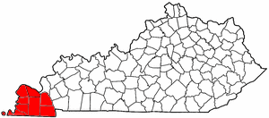
The Jackson Purchase, also known as the Purchase Region or simply the Purchase, is a region in the U.S. state of Kentucky bounded by the Mississippi River to the west, the Ohio River to the north, and Tennessee River to the east. Although officially part of Kentucky at its statehood in 1792, the land did not come under definitive U.S. control until 1818, when Andrew Jackson purchased it from the Chickasaw Indians. Historically, this region has been considered the most "Southern" of Kentucky.

The Cumberland River is a major waterway of the Southern United States. The 688-mile-long (1,107 km) river drains almost 18,000 square miles (47,000 km2) of southern Kentucky and north-central Tennessee. The river flows generally west from a source in the Appalachian Mountains to its confluence with the Ohio River near Paducah, Kentucky, and the mouth of the Tennessee River. Major tributaries include the Obey, Caney Fork, Stones, and Red rivers.

The Kentucky River is a tributary of the Ohio River, 260 miles (418 km) long, in the U.S. Commonwealth of Kentucky. The river and its tributaries drain much of the central region of the state, with its upper course passing through the coal-mining regions of the Cumberland Mountains, and its lower course passing through the Bluegrass region in the north central part of the state. Its watershed encompasses about 7,000 square miles (18,000 km2). It supplies drinking water to about one-sixth of the population of the Commonwealth of Kentucky.
Jared Raymond Lorenzen is a former American football quarterback and former commissioner of the Ultimate Indoor Football League. He played college football at Kentucky and was signed by the New York Giants as an undrafted free agent in 2004.

The prehistory and history of Kentucky spans thousands of years, and has been influenced by the state's diverse geography and central location. It is not known exactly when the first humans arrived in what is now Kentucky. Around 1800 BCE, a gradual transition began from a hunter-gatherer economy to agriculturalism. Around 900 CE, a Mississippian culture took root in western and central Kentucky; by contrast, a Fort Ancient culture appeared in eastern Kentucky. While the two had many similarities, the distinctive ceremonial earthwork mounds constructed in the former's centers were not part of the culture of the latter.

Kentucky was a border state of key importance in the American Civil War. President Abraham Lincoln recognized the importance of the Commonwealth when, in a September 1861 letter to Orville Browning, he wrote:
I think to lose Kentucky is nearly the same as to lose the whole game. Kentucky gone, we cannot hold Missouri, nor Maryland. These all against us, and the job on our hands is too large for us. We would as well consent to separation at once, including the surrender of this capitol.

Lost River Cave is a seven-mile cave system located in Bowling Green, Kentucky. The Lost River originates outside of the cave and flows into it. Lost River Cave contains one of the largest natural entrances in the Eastern U.S. Boat tours are available year-round, but close for Thanksgiving Day, Christmas Eve, Christmas Day, New Year's Day and at noon on New Year's Eve. The river was once listed by Ripley's Believe it or Not as the "Shortest, deepest river in the world" because the blue hole is over 437 feet deep, while the river itself is only 400 feet long. In fact, the blue hole is only 16 feet deep, but is linked to a further underground river. The 72-acre cave property is jointly owned by Western Kentucky University and the non-profit Friends of Lost River Cave.

The Confederate Heartland Offensive, also known as the Kentucky Campaign, was an American Civil War campaign conducted by the Confederate States Army in Tennessee and Kentucky where Generals Braxton Bragg and Edmund Kirby Smith tried to draw neutral Kentucky into the Confederacy by outflanking Union troops under Major General Don Carlos Buell. Though they scored some successes, notably a tactical win at Perryville, they soon retreated, leaving Kentucky primarily under Union control for the rest of the war.

This is a list of the National Register of Historic Places listings in Warren County, Kentucky.

The Cincinnati metropolitan area, informally known as Greater Cincinnati or the Greater Cincinnati Tri-State Area, is a metropolitan area that includes counties in the U.S. states of Ohio, Kentucky, and Indiana around the Ohio city of Cincinnati. The United States Census Bureau's formal name for the area is the Cincinnati–Middletown, OH–KY–IN Metropolitan Statistical Area. As of the 2010 U.S. Census, this MSA had a population of 2,114,580, making Greater Cincinnati the 29th most populous metropolitan area in the United States, the first largest metro area entirely in Ohio, followed by Cleveland (2nd) and Columbus (3rd).