Riverside, Kentucky

Last updated
Riverside
USA Kentucky location map.svg
Red pog.svg
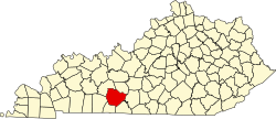
Riverside
Location within the state of Kentucky
Usa edcp location map.svg
Red pog.svg
Riverside
Riverside (the United States)
Coordinates: 37°9′32″N86°32′37″W / 37.15889°N 86.54361°W / 37.15889; -86.54361 Coordinates: 37°9′32″N86°32′37″W / 37.15889°N 86.54361°W / 37.15889; -86.54361
Country United States
State Kentucky
County Warren
Elevation
551 ft (168 m)
Time zone UTC-6 (Central (CST))
  Summer (DST) UTC-5 (CDT)
GNIS feature ID508944 [1]

Riverside is an unincorporated community in Warren County, Kentucky, United States.

Contents

History

A post office called Riverside was established in 1888, and remained in operation until 1988. [2] The name is a bit of a misnomer, as the Green River lies about one mile away from the town site. [3]

Riverside and other towns such as Muldraugh, West Point, Kentucky, and Rosewood, Kentucky are the main setting of the open world survival horror game Project Zomboid.


Related Research Articles

Riverside may refer to:

<span class="mw-page-title-main">Warren County, Kentucky</span> County in Kentucky, United States

Warren County is a county located in the south central portion of the U.S. state of Kentucky. As of the 2020 census, the population was 134,554, making it the fifth-most populous county in Kentucky. The county seat is Bowling Green. Warren County is now classified as a wet county after voters approved the measure in 2018. The measure became law in January 2019 that allows alcohol to be sold county wide.

<span class="mw-page-title-main">Todd County, Kentucky</span> County in Kentucky, United States

Todd County is a county located in the U.S. state of Kentucky. As of the 2020 census, the population was 12,243. Its county seat is Elkton. The county is named for Colonel John Todd, who was killed at the Battle of Blue Licks in 1782 during the American Revolution.

<span class="mw-page-title-main">Augusta, Kentucky</span> City in Kentucky, United States

Augusta is a home rule-class city in Bracken County, Kentucky, in the United States. It is sited upon the southern bank of the Ohio River. As of the 2010 census, the city population was 1,190. When Bracken County was organized in 1796, Augusta was the county seat. In 1839, a new county courthouse was built at a more central location in Brooksville. The city was formally incorporated by the state assembly in 1850.

<span class="mw-page-title-main">Bowling Green, Kentucky</span> City in Kentucky, United States

Bowling Green is a home rule-class city and the county seat of Warren County, Kentucky, United States. Founded by pioneers in 1798, Bowling Green was the provisional capital of Confederate Kentucky during the American Civil War. As of the 2020 census, its population of 72,294 made it the third-most-populous city in the state, after Louisville and Lexington; its metropolitan area, which is the fourth largest in the state after Louisville, Lexington, and Northern Kentucky, had an estimated population of 179,240; and the combined statistical area it shares with Glasgow has an estimated population of 233,560.

<span class="mw-page-title-main">Northern Kentucky</span> Geographical region

Northern Kentucky is the third-largest metropolitan area in the United States Commonwealth of Kentucky after Louisville and Lexington, and its cities and towns serve as the de facto "south side" communities of Cincinnati, Ohio. The three main counties of this metro area are Boone, Kenton, and Campbell along the Ohio River, with other counties also included. The label "Northern Kentucky" is used to demonstrate the common identity shared across county and city lines by the residents of these northern counties. Arguably, the label seeks to reverse the divisions that occurred to Campbell County, which, in 1794, included the land of Boone, Kenton, Pendleton Counties, and most of Bracken and Grant Counties. The urban and suburban areas of the northern counties are densely populated. Indeed, of Greater Cincinnati's over two million residents, 450,994 of them live in Northern Kentucky (2019), with the three most northern counties contributing 394,163 residents themselves. The largest cities in each of the three most northern counties are Covington, Florence, and Fort Thomas.

<span class="mw-page-title-main">Riverside, Rhode Island</span>

Riverside is a neighborhood in the city of East Providence in the U.S. state of Rhode Island. Despite not being an incorporated city, Riverside has its own zip code, 02915, and is an acceptable mailing address according to the United States Postal Service. Riverside has a population of approximately 20,000 people.

<span class="mw-page-title-main">Neighborhoods in Louisville, Kentucky</span>

This is a list of official neighborhoods in Louisville, Kentucky. Like many older American cities, Louisville has well-defined neighborhoods, many with well over a century of history as a neighborhood.

<span class="mw-page-title-main">Independence, Indiana</span> Unincorporated community in Indiana, United States

Independence is a small unincorporated community in Warren Township, Warren County, in the U.S. state of Indiana.

Riparius is a hamlet in the Upper Hudson River Valley of Warren County, New York, United States. Riparius was formerly known as Riverside until the state changed the name to prevent confusion with several other places of the same name. "Riparius" is a Latin equivalent for "Riverside". Riparius is located within the towns of Johnsburg and Chester.

A board of supervisors is a governmental body that oversees the operation of county government in the U.S. states of Arizona, California, Iowa, Mississippi, Virginia, and Wisconsin, as well as 16 counties in New York. There are equivalent agencies in other states.

<span class="mw-page-title-main">Logan Township, Fountain County, Indiana</span> Township in Indiana, United States

Logan Township is one of eleven townships in Fountain County, Indiana, United States. As of the 2010 census, its population was 3,672 and it contained 1,685 housing units.

Pig is an unincorporated community in southern Edmonson County, Kentucky, United States. Pig is generally referred to as the area near KY 422, stretching from the road's southern terminus at US 31-W, north along KY 259 towards Rhoda and KY 70 towards Brownsville.

<span class="mw-page-title-main">U.S. Route 231 in Kentucky</span> Section of U.S. Highway in Kentucky

U.S. Route 231 in Kentucky runs 86.465 miles (139.152 km) from the Tennessee state line near Adolphus to the William H. Natcher Bridge on the Ohio River near Rockport, Indiana. It crosses the state mainly in the west-central region, traversing Allen, Warren, Butler, Ohio, and Daviess Counties.

Rosewood is an unincorporated community located in Muhlenberg County, Kentucky, United States.

Warren is an unincorporated community and coal town in Knox County, Kentucky, United States. It was also known as Cumberland Station.

<span class="mw-page-title-main">Cincinnati metropolitan area</span> Metropolitan area in the United States

The Cincinnati metropolitan area is a metropolitan area centered on Cincinnati and including surrounding counties in the U.S. states of Ohio, Kentucky, and Indiana. The area is commonly known as Greater Cincinnati.

Rockfield is an unincorporated community in Warren County, in the U.S. state of Kentucky.

Rockland is an unincorporated community in Warren County, in the U.S. state of Kentucky.

References

  1. U.S. Geological Survey Geographic Names Information System: Riverside, Kentucky
  2. "Warren County". Jim Forte Postal History. Retrieved 24 December 2015.
  3. Rennick, Robert M. Kentucky Place Names. University Press of Kentucky. p. 252. ISBN   0-8131-2631-2.