Bristow, Kentucky

Last updated

Bristow
USA Kentucky location map.svg
Red pog.svg
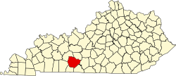
Bristow
Location within the state of Kentucky
Usa edcp location map.svg
Red pog.svg
Bristow
Bristow (the United States)
Coordinates: 37°1′7″N86°21′36″W / 37.01861°N 86.36000°W / 37.01861; -86.36000
Country United States
State Kentucky
County Warren
Elevation
541 ft (165 m)
Time zone UTC-6 (Central (CST))
  Summer (DST) UTC-5 (CDT)
ZIP codes
42101
Area code(s) 270 and 364
GNIS feature ID507586 [1]

Bristow is an unincorporated community in Warren County, Kentucky, United States. Bristow is part of the Bowling Green Metropolitan Statistical Area.

Contents

Geography

The community is located in east-central Warren County along U.S. Route 31W (US 31W) during its concurrency with US 68/KY 80. It is located less than a mile east of Plum Springs, and about 1.5 miles (2.4 km) southwest of US 31W/US 68/KY 80's junction with Kentucky Route 526 (KY 526), just off the northeastern edge of Bowling Green city limits. [2] The community can be easily accessed from I-65 via its Exit 28 interchange.

Education

Students in Bristow attend institutions of the Warren County Public Schools. The general area is home to Bristow Elementary, Warren East Middle, and Warren East High Schools.

References

  1. U.S. Geological Survey Geographic Names Information System: Bristow, Kentucky
  2. Kentucky Transportation Cabinet (1993). Warren County Highway Map (PDF) (Map). 1:125,000. Frankfort: Kentucky Transportation Cabinet. § B4. Retrieved May 22, 2023.