Roddam, Northumberland

Last updated

Roddam
Roddam Hall - geograph.org.uk - 1844306.jpg
Northumberland UK location map.svg
Red pog.svg
Roddam
Location within Northumberland
Area12.36 km2 (4.77 sq mi)
Population77 (2001 census)
  Density 6/km2 (16/sq mi)
OS grid reference NU025204
Civil parish
  • Roddam
Unitary authority
Shire county
Region
Country England
Sovereign state United Kingdom
List of places
UK
England
Northumberland
55°28′38″N1°57′45″W / 55.477252°N 1.9624936°W / 55.477252; -1.9624936

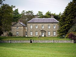
Roddam is a village and civil parish about 24 miles from Morpeth, in the county of Northumberland, England. In 2001 the parish had a population of 77. [1] The parish touches Bewick, Hedgeley, Ilderton, Ingram and Lilburn. [2] It lies near the foot of the Cheviot Hills. [3]

Contents

Landmarks

There are 16 listed buildings in Roddam, including Roddam Hall. [4]

History

The name "Roddam" means 'At the clearings'. [5] Roddam is a deserted medieval village, the village existed in 1296 but by the 19th century it had almost disappeared. [6] Roddam was formerly a township in the parish of Ilderton, [7] in 1866 Roddam became a civil parish in its own right. On 1 April 1955 Reaveley, Roseden and Wooperton parishes were merged with Roddam. [8]

References

  1. Neighbourhood Statistics
  2. "Roddam". Ordnance Survey . Retrieved 15 May 2021.
  3. "Cheviotside (Northumberland)". Keys to the Past. Retrieved 15 May 2021. Note title "Cheviotside" appears to be an error.
  4. "Listed buildings in Roddam, Northumberland". British Listed Buildings. Retrieved 15 May 2021.
  5. "Roddam Key to English Place-names". The University of Nottingham. Retrieved 15 May 2021.
  6. "Roddam (Cheviotside)". Keys to the Past. Retrieved 15 May 2021.
  7. "History of Roddam, in Berwick upon Tweed and Northumberland". A Vision of Britain through Time . Retrieved 15 May 2021.
  8. "Relationships and changes Roddam Tn/CP through time". A Vision of Britain through Time. Retrieved 15 May 2021.