Roggenburg, Bavaria

Last updated
Roggenburg
6188 Kloster Roggenburg.jpg
Wappen Roggenburg.svg
Coat of arms
Location of Roggenburg within Neu-Ulm district
Roggenburg in NU.svg
Germany adm location map.svg
Red pog.svg
Roggenburg
Bavaria location map.svg
Red pog.svg
Roggenburg
Coordinates: 48°16′N10°13′E / 48.267°N 10.217°E / 48.267; 10.217 Coordinates: 48°16′N10°13′E / 48.267°N 10.217°E / 48.267; 10.217
Country Germany
State Bavaria
Admin. region Schwaben
District Neu-Ulm
Government
   Mayor (202026) Mathias Stölzle [1]
Area
  Total27.41 km2 (10.58 sq mi)
Elevation
512 m (1,680 ft)
Population
 (2020-12-31) [2]
  Total2,780
  Density100/km2 (260/sq mi)
Time zone UTC+01:00 (CET)
  Summer (DST) UTC+02:00 (CEST)
Postal codes
89297
Dialling codes 07300
Vehicle registration NU
Website www.roggenburg.de

Roggenburg is a municipality in the district of Neu-Ulm in Bavaria in Germany.

Contents

Roggenburg is known for the Roggenburg Abbey, which is used today by the Premonstratensians. An environment and culture center with an overregional commuting area is located near the abbey.

Geographical location

The municipality lies in the region "Donau-Iller" in central Swabia, approximately 30 km southeast of Ulm and 40 km north of Memmingen. The districts Roggenburg, Biberach and Meßhofen are located on the Biber river, the districts Ingstetten, Schießen and Unteregg at the Osterbach, while Schleebuch is located between these two rivers.

Biberach around 1900 Biberach-roggenburg-bayern-1900.jpg
Biberach around 1900

Politics

The municipal council has 14 members plus the major.

ÜWV Schießen FW Meßhofen/Roggenburg WG Biberach WG Ingstetten Total
2002534214 seats

Related Research Articles

Nersingen Place in Bavaria, Germany

Nersingen is a municipality in the District of Neu-Ulm in Bavaria, Germany. The neighbours are Neu-Ulm, Elchingen, Bibertal and Pfaffenhofen an der Roth.

Elchingen Place in Bavaria, Germany

Elchingen is a municipality about 7 km east of Ulm–Neu-Ulm in the district of Neu-Ulm in Bavaria, Germany

Ettal Place in Bavaria, Germany

Ettal is a German municipality in the district of Garmisch-Partenkirchen, in Bavaria.

Osterberg Place in Bavaria, Germany

Osterberg is a municipality in the district of Neu-Ulm in Bavaria in Germany.

Lauingen Place in Bavaria, Germany

Lauingen is a town in the district of Dillingen in Bavaria, Germany. It is located on the left bank of the Danube, 5 km west of Dillingen, and 37 km northeast of Ulm.

Geisenfeld Place in Bavaria, Germany

Geisenfeld is a town in the district of Pfaffenhofen, in Bavaria, Germany. It is situated on the river Ilm, 16 km (9.94 mi) southeast of Ingolstadt. The town grew up around Geisenfeld Abbey, a convent founded in 1037.

Dinkelscherben Place in Bavaria, Germany

Dinkelscherben is a municipality in the district of Augsburg in Bavaria in Germany. Fleinhausen, Anried, Breitenbronn, Ettelried, Grünenbaindt, Häder, Lindach, Oberschöneberg and Ried are villages that make up the municipality of Dinkelscherben.

Lalling Place in Bavaria, Germany

Lalling is a municipality in the Lower Bavarian district of Deggendorf in Germany. It is a nationally recognized resort town.

Dürrlauingen Place in Bavaria, Germany

Dürrlauingen is a municipality in the district of Günzburg in Bavaria in Germany.

Altenstadt, Swabia Place in Bavaria, Germany

Altenstadt is a municipality in the district of Neu-Ulm in Bavaria in Germany.

Bellenberg Place in Bavaria, Germany

Bellenberg is a municipality in the district of Neu-Ulm in Bavaria in Germany.

Buch, Swabia Place in Bavaria, Germany

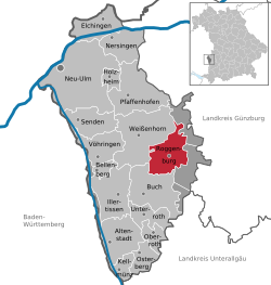
Buch is a municipality in the district of Neu-Ulm in Bavaria in Germany.

Kellmünz Place in Bavaria, Germany

Kellmünz(official: Kellmünz a.d.Iller) is a municipality in the district of Neu-Ulm in Bavaria in Germany.

Oberroth Place in Bavaria, Germany

Oberroth is a municipality in the district of Neu-Ulm in Bavaria in Germany.

Unterroth Place in Bavaria, Germany

Unterroth is a municipality in the district of Neu-Ulm in Bavaria in Germany.

Pielenhofen Place in Bavaria, Germany

Pielenhofen is a municipality in the district of Regensburg in Bavaria in Germany. It lies on the Naab River.

Hiltenfingen Place in Bavaria, Germany

Hiltenfingen is a municipality in the district of Augsburg in Bavaria in Germany. It is part of the administrative region of Swabia and of the Verwaltungsgemeinschaft of Langerringen.

Ustersbach Place in Bavaria, Germany

Ustersbach is a municipality in the district of Augsburg in Bavaria in Germany. It is situated approx. 20 km west of Augsburg

Holzheim, Neu-Ulm Place in Bavaria, Germany

Holzheim is a municipality in the district of Neu-Ulm in Bavaria in Germany.

Theres Place in Bavaria, Germany

Theres is a municipality on the river Main, in the district of Haßberge in Bavaria in Germany. It was once the site of Theres Abbey, but the church was demolished in 1809.

References

  1. Liste der ersten Bürgermeister/Oberbürgermeister in kreisangehörigen Gemeinden, Bayerisches Landesamt für Statistik, 15 July 2021.
  2. "Tabellenblatt "Daten 2", Statistischer Bericht A1200C 202041 Einwohnerzahlen der Gemeinden, Kreise und Regierungsbezirke". Bayerisches Landesamt für Statistik und Datenverarbeitung (in German). June 2021.