
The East Frisian Islands are a chain of islands in the North Sea, off the coast of East Frisia in Lower Saxony, Germany. The islands extend for some 90 kilometres (56 mi) from west to east between the mouths of the Ems and Jade / Weser rivers and lie about 3.5 to 10 km offshore. Between the islands and the mainland are extensive mudflats, known locally as Watten, which form part of the Wadden Sea. In front of the islands are Germany's territorial waters, which occupy a much larger area than the islands themselves. The islands, the surrounding mudflats and the territorial waters form a close ecological relationship. The island group makes up about 5% of the Lower Saxony Wadden Sea National Park.

Jever is the capital of the district of Friesland in Lower Saxony, Germany. The name Jever is usually associated with a major brand of beer, Jever Pilsener, which is produced there. The city is also a popular holiday resort. Jever was granted city status in 1536. Unofficially Jever is sometimes referred to as Marienstadt in reference to Maria of Jever, the last independent ruler of the city. The inhabitants of Jever are named Jeveraner ("Jeverans").

Wangerooge is one of the 32 Frisian Islands in the North Sea located close to the coasts of the Netherlands, Germany and Denmark. It is also a municipality in the district of Friesland in Lower Saxony in Germany.

Baltrum is a barrier island off the coast of East Frisia, in Germany, and is a municipality in the district of Aurich, Lower Saxony. It is located in-between the chain of the seven inhabited East Frisian Islands. Baltrum is the smallest island in this chain by area and inhabitants. It has a land area of 6.5 square kilometres, and a population in (2011) of just over 500 resident inhabitants.
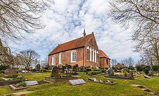
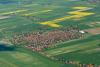
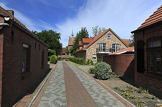
Dornum is a village and a municipality in the East Frisian district of Aurich, in Lower Saxony, Germany. It is located near the North Sea coast, approx. 15 km east of Norden, and 20 km north of Aurich.

Langeoog is one of the seven inhabited East Frisian Islands at the edge of the Lower Saxon Wadden Sea in the southern North Sea, located between Baltrum Island (west), and Spiekeroog (east). It is also a municipality in the district of Wittmund in Lower Saxony, Germany. The name Langeoog means Long Island in the Low German dialect.
Neßmersiel is an East Frisian village and seaside resort on the Wadden Sea coast in Lower Saxony, Germany. It is an Ortsteil of the municipality of Dornum, in the district of Aurich. Neßmersiel is located about 5 kilometers northwest of Dornum.

Berumbur is a municipality in the district of Aurich, in Lower Saxony, Germany. It is part of the municipal association (Samtgemeinde) of Hage. In 2022, the municipality had approximately 2,700 inhabitants and covers an area of 6.42 square kilometers. It is located directly east of the town of Hage.
Frisian Americans are Americans with full or partial Frisian ancestry.
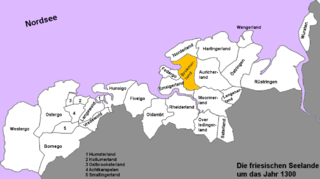
The Brokmerland is a landscape and historic territory, located in western East Frisia, which covers the area in and around the present-day communities of Brookmerland and Südbrookmerland. The Brokmerland borders in the east on the Harlingerland and in the north on the Norderland. The historic Brokmerland is usually written with only one "o". Occasionally one also finds the spelling "Broekmerland", while today's communities have chosen to spell the name with a double "o".
Uko Fockena was an East Frisian chieftain of Moormerland and Emsigerland.
Lütet Attena was a 14th-century East Frisian chieftain of Dornum and Nesse in the Norderland area.

Nesse is an East Frisian village in Lower Saxony, Germany. It is an Ortsteil of the municipality of Dornum, in the district of Aurich. It is situated near the Wadden Sea coast, approximately 2.5 km west of the village of Dornum, and 20 km north of the town of Aurich. As of 2021, the village and surrounding farms had a population of 639.

Norden is a railway station located in Norden in East Frisia, Lower Saxony, Germany. It is a junction station situated on the Emsland Railway line, with train services provided by Deutsche Bahn, and the historic Ostfriesische Küstenbahn. The latter is operated by a heritage train on Sundays from June to October.
Visquard is a village in the region of East Frisia, in Lower Saxony, Germany. It is part of the municipality of Krummhörn. The village is located to the north of Pewsum and to the south of Greetsiel.

Dornumergrode is an East Frisian village near the Wadden Sea coast in Lower Saxony, Germany. It is an Ortsteil of the municipality of Dornum, in the Aurich district.
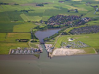
Dornumersiel is an East Frisian village and coastal resort on the Wadden Sea coast in Lower Saxony, Germany. It is an Ortsteil of the municipality of Dornum, in the Aurich district. The village is converged with the village core of Westeraccumersiel. The two settlements are only divided by Dornumersieler Tief, the historical border of Norderland and Harlingerland. Dornumersiel has been part of the municipality of Dornum since 2001.
Schwittersum is an East Frisian village in Lower Saxony, Germany. It is an Ortsteil of the municipality of Dornum, in the district of Aurich. Schwittersum is located directly to the southeast of Dornum, practically bordering its residential area.
Westdorf is an East Frisian village in Lower Saxony, Germany. It is an Ortsteil of the municipality of Dornum, in the district of Aurich. Administratively, the settlement of Ostdorf, located just to the east, belongs to the district of Westdorf.

Westeraccum is an East Frisian village in Lower Saxony, Germany. It is an Ortsteil of the municipality of Dornum, in the district of Aurich. The village is located just to the northeast of Dornum.


