
Ashland is a city in Jackson County, Oregon, United States. It lies along Interstate 5 approximately 16 miles (26 km) north of the California border and near the south end of the Rogue Valley. The city's population was 21,360 at the 2020 census.

Siskiyou County is a county located in the northwestern part of the U.S. state of California. As of the 2020 census, the population was 44,076. Its county seat is Yreka and its highest point is Mount Shasta. It falls within the Cascadia bioregion.

Jackson County is one of the 36 counties in the U.S. state of Oregon. As of the 2020 census, the population was 223,259. The county seat is Medford. The county is named for Andrew Jackson, the seventh president of the United States.

Medford is a city in and the county seat of Jackson County, Oregon, in the United States. As of the 2020 United States Census on April 1, 2020, the city had a total population of 85,824, making it the 8th most populous city in Oregon, and a metropolitan area population of 223,259, making the Medford MSA the fourth largest metro area in Oregon. The city was named in 1883 by David Loring, civil engineer and right-of-way agent for the Oregon and California Railroad, after Medford, Massachusetts, which was near Loring's hometown of Concord, Massachusetts. Medford is near the middle fork of Bear Creek.

The Rogue River in southwestern Oregon in the United States flows about 215 miles (346 km) in a generally westward direction from the Cascade Range to the Pacific Ocean. Known for its salmon runs, whitewater rafting, and rugged scenery, it was one of the original eight rivers named in the Wild and Scenic Rivers Act of 1968. Beginning near Crater Lake, which occupies the caldera left by the explosive volcanic eruption and collapse of Mount Mazama, the river flows through the geologically young High Cascades and the older Western Cascades, another volcanic province. Further west, the river passes through multiple exotic terranes of the more ancient Klamath Mountains. In the Kalmiopsis Wilderness section of the Rogue basin are some of the world's best examples of rocks that form the Earth's mantle. Near the mouth of the river, the only dinosaur fragments ever discovered in Oregon were found in the Otter Point Formation, along the coast of Curry County.

The Siskiyou Mountains are a coastal subrange of the Klamath Mountains, and located in northwestern California and southwestern Oregon in the United States. They extend in an arc for approximately 100 miles (160 km) from east of Crescent City, California, northeast along the north side of the Klamath River into Josephine and Jackson counties in Oregon. The mountain range forms a barrier between the watersheds of the Klamath River to the south and the Rogue River to the north. Accordingly, much of the range is within the Rogue River – Siskiyou and Klamath national forests, and the Pacific Crest Trail follows a portion of the crest of the Siskiyous.
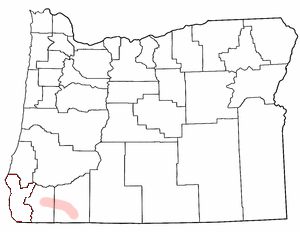
The Rogue Valley is a valley region in southwestern Oregon in the United States. Located along the middle Rogue River and its tributaries in Josephine and Jackson counties, the valley forms the cultural and economic heart of Southern Oregon near the California border. The largest communities in the Rogue Valley are Medford, Ashland and Grants Pass. The most populated part of the Rogue Valley is not along the Rogue proper, but along the smaller Bear Creek tributary. The Rogue Valley is a popular fall destination in Oregon because of the hardwood forests there.

The Siskiyou Trail stretched from California's Central Valley to the Columbia River in Washington State; modern-day Interstate 5 follows this pioneer path. Originally based on existing Native American foot trails winding their way through river valleys, the Siskiyou Trail provided the shortest practical travel path between early settlements in California and Oregon.

The Central Oregon & Pacific Railroad is a Class II railroad operating between Northern California and Eugene, Oregon, United States. It was previously a mainline owned by the Southern Pacific Railroad (SP) between Eugene and Weed, California via Medford, Oregon. SP sold the route on December 31, 1994, in favor of using its route to Eugene via Klamath Falls, Oregon and Cascade Summit.
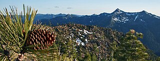
The Rogue River–Siskiyou National Forest is a United States National Forest in the U.S. states of Oregon and California. The formerly separate Rogue River and Siskiyou National Forests were administratively combined in 2004. Now, the Rogue River–Siskiyou National Forest ranges from the crest of the Cascade Range west into the Siskiyou Mountains, covering almost 1.8 million acres (7,300 km2). Forest headquarters are located in Medford, Oregon.
Interstate 5 (I-5) in the U.S. state of Oregon is a major Interstate Highway that traverses the state from north to south. It travels to the west of the Cascade Mountains, connecting Portland to Salem, Eugene, Medford, and other major cities in the Willamette Valley and across the northern Siskiyou Mountains. The highway runs 308 miles (496 km) from the California state line near Ashland to the Washington state line in northern Portland, forming the central part of Interstate 5's route between Mexico and Canada.

Roxy Ann Peak, also known as Roxy Ann Butte, is a 3,576-foot-tall (1,090 m) mountain in the Western Cascade Range at the eastern edge of Medford, Oregon. Composed of several geologic layers, the majority of the peak is of volcanic origin and dates to the early Oligocene epoch. It is primarily covered by oak savanna and open grassland on its lower slopes, and mixed coniferous forest on its upper slopes and summit, stopping short of the summit. Despite the peak's relatively small topographic prominence of 753 feet (230 m), it rises 2,200 feet (670 m) above Medford and is visible from most of the Rogue Valley. The mountain is Medford's most important viewshed, open space reserve, and recreational resource.

Rogue Valley Transportation District is a transportation district serving the greater Jackson County, Oregon area. The district serves the cities of Medford, Ashland, White City, Phoenix, Talent, Jacksonville, and Central Point. The district also provides paratransit services to older adults and people with disabilities within its route coverage area.

The Cascade was a passenger train of the Southern Pacific on its route between Oakland, California, and Portland, Oregon, with a sleeping car to Seattle, Washington. The Southern Pacific started the train on April 17, 1927, soon after the opening of its Cascade Line between Black Butte, California, and Springfield, Oregon.
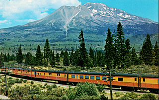
The Shasta Daylight was a Southern Pacific Railroad passenger train between Oakland Pier in Oakland, California, and Portland, Oregon. It started on July 10, 1949, and was SP's third "Daylight" streamliner; it had a fast 15-hour-30-minute schedule in either direction for the 713-mile (1,147 km) trip through some of the most beautiful mountain scenery of any train in North America. The Shasta Daylight replaced heavyweight trains on the same route that had taken nearly a day and night to complete the run. The Shasta Daylight was the first diesel powered Daylight and the only Daylight to run beyond California. The scenic route of the Shasta Daylight passed its namesake Mount Shasta in daylight hours.
The Southern Oregon Land Conservancy is an accredited land trust that works exclusively in Southern Oregon. Its headquarters are located in Ashland, Oregon. The mission of the Southern Oregon Land Conservancy is to protect special lands in the Rogue River Basin and surrounding areas for this and future generations by working cooperatively with landowners and communities. Its service area includes all of Jackson, Josephine, Curry, Coos, and Southern Douglas Counties.
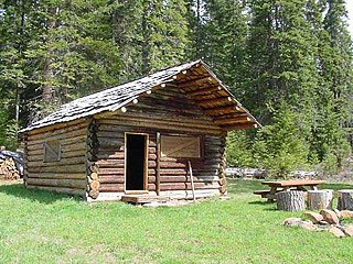
The Willow Prairie Cabin is a rustic one-room cabin located in the Rogue River-Siskiyou National Forest in western Oregon, United States. It was built by a road construction crew in 1924. When the road was finished the United States Forest Service began using it to house fire crews assigned to patrol the surrounding National Forest. The Forest Service now rents the cabin to recreational visitors. The Willow Prairie Cabin is listed on the National Register of Historic Places.

Pilot Rock is a prominent volcanic plug located in the western Cascade Range near the east end of the Siskiyou Mountains, just east of the Siskiyou Summit near Ashland, Oregon. Rising thousands of feet above the Shasta and Rogue valleys, it is a landmark distinguishable from over 40 miles (64 km) away. At 25.6 million years old, it is one of the oldest formations of the Cascade Range. The rock is protected by the Cascade–Siskiyou National Monument and the Soda Mountain Wilderness. Several trails pass near Pilot Rock, including the Pacific Crest Trail.

The Pengra Pass rail route, also known as the Natron Cutoff, the Cascade Subdivision, or the Cascade Line, is a Union Pacific Railroad line connecting Eugene, Oregon, with Klamath Falls, Oregon. Construction of the line began in 1905 and was completed in the mid-1920s. Its name denotes a mountain pass on the Lane County–Klamath County boundary in the Cascade Mountains of Oregon, about 1.5 miles (2.4 km) from Willamette Pass. The line heads southeast from Eugene, up the Cascades and over Pengra Pass, then southward beside U.S. Route 97 to Klamath Falls, where it splits in two, each track continuing into California. The route has at least 22 tunnels, several snow sheds and multiple bridges across canyons. BNSF has trackage rights between Klamath Falls and Chemult.

The Medford Southern Pacific Railroad Passenger Depot is a former rail station located in Medford, Oregon listed on the National Register of Historic Places.


