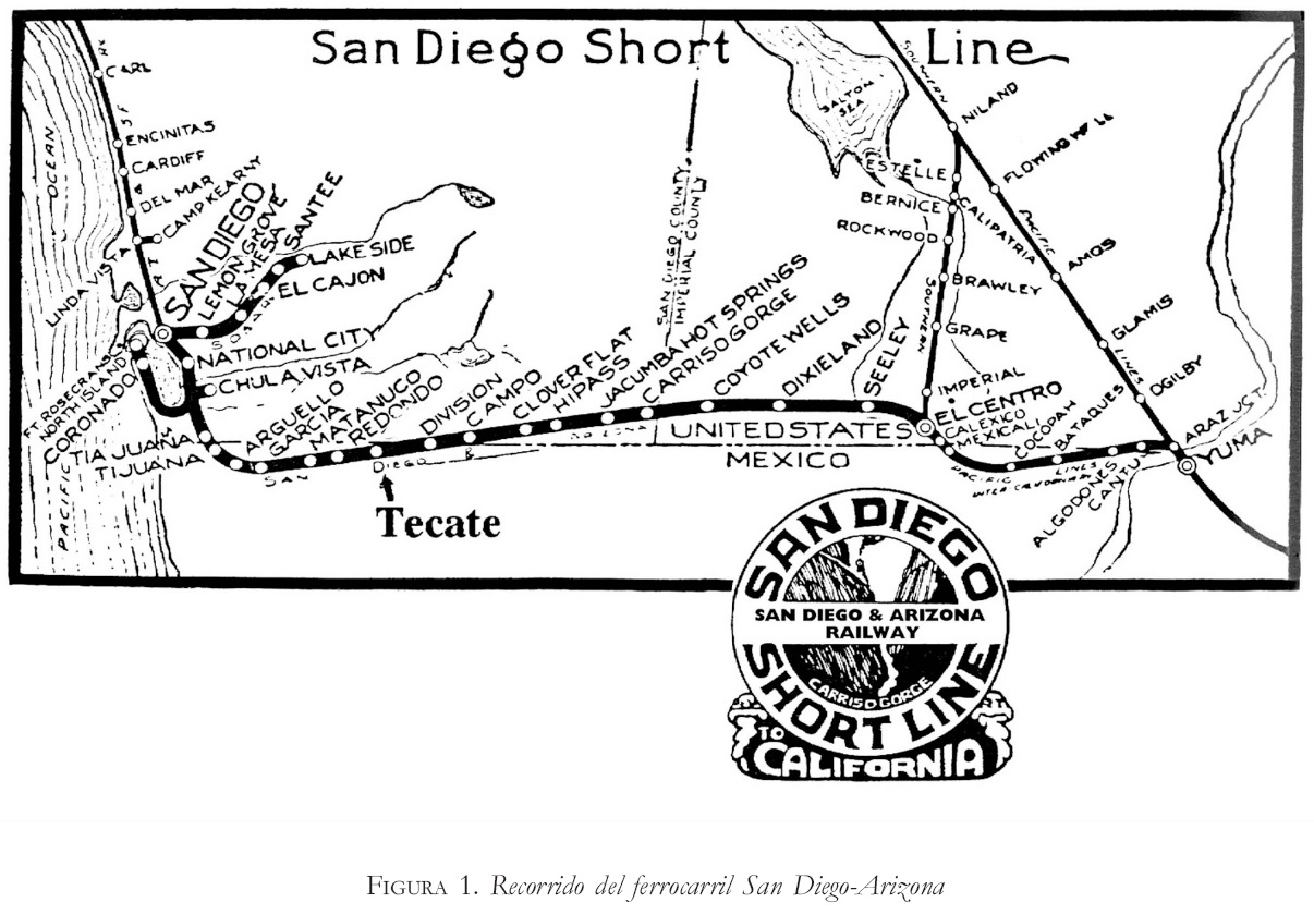
Route
Among the Southern Pacific passenger trains running from Arizona to southern California, it was distinctive for stopping in Mexico and for having an international branch running into Mexico a second time, stopping between Calexico and San Diego. In most of the Arizona section, it passes through an area acquired by the Gadsden Purchase.
The Imperial's main route ran west to Los Angeles. Heading west of Yuma it went into Mexico for two stops, then returned to Calexico; there, the main route continued to Los Angeles.
A southern branch split from the main route at Calexico on the San Diego Short Line. It crossed the Mexico–United States border, then made stops in Baja California at Mexicali, before returning to California, stopping in Calexico and El Centro. It then crossed into Mexico, stopping at Tijuana, and finally crossed to the United States to finish in San Diego. [1]
The route had its origins as a local train between San Diego and Yuma. It was suspended from 1942 to 1946, as a result of World War II. Its service was truncated by 1958, continuing into 1967. [2]

Imperial County is a county located on the southeast border of the U.S. state of California. As of the 2020 census, the population was 179,702, making it the least populous county in Southern California. The county seat and largest city is El Centro. Imperial is the most recent California county to be established, as it was created in 1907 out of the eastern half of San Diego County.

Calexico is a city in southern Imperial County, California. Situated on the Mexican border, it is linked economically with the much larger city of Mexicali, the capital of the Mexican state of Baja California. It is about 122 miles (196 km) east of San Diego and 62 miles (100 km) west of Yuma, Arizona. Calexico, along with six other incorporated Imperial County cities, forms part of the larger populated area known as the Imperial Valley.

Mexicali is the capital city of the Mexican state of Baja California. The city, which is the seat of the Mexicali Municipality, has a population of 689,775, according to the 2010 census, while the Calexico–Mexicali metropolitan area is home to 1,000,000 inhabitants on both sides of the Mexico–United States border. Mexicali is a regional economic and cultural hub for the border region of The Californias.

The Imperial Valley of Southern California lies in Imperial and Riverside counties, with an urban area centered on the city of El Centro. The Valley is bordered by the Colorado River to the east and, in part, the Salton Sea to the west. Farther west lies the San Diego and Imperial County border. To the north is the Coachella Valley region of Riverside County, which together with Imperial Valley form the Salton Trough, or the Cahuilla Basin, also the county line of Imperial and Riverside counties, and to the south the international boundary with Mexico.

The San Diego and Arizona Railway was a 148-mile (238 km) short line U.S. railroad founded by entrepreneur John D. Spreckels, and dubbed "The Impossible Railroad" by engineers of its day due to the immense logistical challenges involved. It linked San Diego, its western terminus, with El Centro, its eastern terminus, where passengers could connect with Southern Pacific's transcontinental lines, eliminating the need to first travel north via Los Angeles or Riverside.

The San Diego and Imperial Valley Railroad (SD&IV) is a class III railroad operating freight rail service in the San Diego area, providing service to customers in the region and moving railcars between the end of BNSF Railway in downtown San Diego and the Mexico–United States border in San Ysidro. It was established in October 1984 and is owned and operated by Genesee & Wyoming.

The Golden State was a named passenger train between Chicago and Los Angeles from 1902–1968 on the Chicago, Rock Island and Pacific Railroad and the Southern Pacific Company (SP) and predecessors. It was named for California, the “Golden State”.

The Argonaut was the Southern Pacific Railroad's secondary passenger train between New Orleans and Los Angeles via Houston, San Antonio, and El Paso, Texas; Tucson, Arizona; and Palm Springs, California. It started in 1926 on a 61 hr 35 min schedule Los Angeles to New Orleans, five hours slower than the Sunset Limited; it was discontinued west of Houston in 1958. In earlier years it carried sleeping cars from New Orleans to Yuma that would continue to San Diego via San Diego and Arizona Eastern Railway, a SP subsidiary. Westbound trains carried sleeping cars from New Orleans and Houston to San Antonio.
The Ferrocarril Sonora–Baja California is a former railroad line of Mexico that built the line from Mexicali, Baja California, to Benjamín Hill, Sonora in 1948. It interchanged with the Southern Pacific Railroad at Calexico, California, and with the Ferrocarril del Pacifico in Benjamin Hill, Sonora. Before 1960, The SP-controlled Inter-California railroad provided trackage rights for the SBC from Pascualitos to the International Border. SBC took control of that part after the demise of the Inter-Cal.

The Inter-California Railway, known in Spanish as the Ferrocarril Inter-California, also known as the Inter-Cal, is a former railroad line which connected the Californias by train. It operated between the American state of California and the Mexican state of Baja California.
San Diego–Tijuana is an international transborder agglomeration, straddling the border of the adjacent North American coastal cities of San Diego, California, United States, and Tijuana, Baja California, Mexico. The 2020 population of the region was 5,456,577, making it the largest bi-national conurbation shared between the United States and Mexico, and the second-largest shared between the US and another country. The conurbation consists of San Diego County, in the United States and the municipalities of Tijuana, Rosarito Beach (126,980), and Tecate (108,440) in Mexico. It is the third most populous region in the California–Baja California region, smaller only than the metropolitan areas of Greater Los Angeles and the San Francisco Bay Area.
Air Bahia was an airline with flights to Mexico which also served Las Vegas and Tucson during its existence.

The 2010 Baja California earthquake occurred on April 4 with a moment magnitude of 7.2 and a maximum Mercalli intensity of VII. The shock originated at south of Guadalupe Victoria, Baja California, Mexico.
Cerro Prieto is a volcano located approximately 29 km (18 mi) SSE of Mexicali in the Mexican state of Baja California. The volcano lies astride a spreading center associated with the East Pacific Rise. This spreading center is also responsible for a large geothermal field, which has been harnessed to generate electric power by the Cerro Prieto Geothermal Power Station.
The Cerro Prieto Fault is a transform fault located in far northern Baja California. It runs between the Cerro Prieto spreading center located southwest of Mexicali, and the Wagner Basin, another spreading center which lies under the Gulf of California. These spreading centers are part of the East Pacific Rise, the northern leg of which has formed the Gulf of California by steadily rifting the Baja California peninsula away from the mainland of Mexico.
Transportation in San Diego–Tijuana occurs by various means. Though, in the four cities of San Diego, Tijuana, Tecate, and Rosarito Beach, the automobile serves as most important means of transportation. The international metropolitan region maintains an intricate highway infrastructure. As a large metropolitan area in Western North America, many roadways, including Interstates, State Routes, and Mexican Federal Highways, hold a terminus in the area. These roads have grown accustomed to support the masses of the commuting populace within the international region and are constantly being expanded and/or renovated. Transportation is a crucial issue in the metropolitan area. The streets and highways of the region affect environmental health and have influence over the degree of regional connectivity. Binational discussions about coordinating public transportation across the border are currently underway. San Diego–Tijuana is the site of two major international airports and numerous regional airports. It is also the site of the Port of San Diego and miles from the nearby Port of Ensenada.
The Butterfield Overland Mail route in Baja California was created as a result of an act by the United States Congress on March 3, 1857, and operated until June 30, 1861 as part of the Second Division of the route. Subsequently other stage lines operated along the route until the Southern Pacific Railroad arrived in Yuma, Arizona.
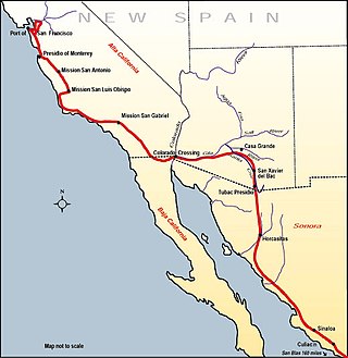
Fort Romualdo Pacheco also called Fuerte de Laguna Chapala was a Mexican fort built in 1825 and was abandoned a year later in 1826. The fort was 100 feet square with thick stone and adobe walls. The fort was built by Lieutenant Alfrez Jose Antonio Romualdo Pacheco Sr. in response to the attacked on travelers on the route made by Juan Bautista de Anza's expedition in 1774 from Sonora to Alta California. The fort was built after Fernando Rivera y Moncada, many of his soldiers, Francisco Garcés and his local missionaries, were killed at Mission San Pedro y San Pablo de Bicuñer in that is called the Yuma Revolt or Yuma Massacre on July 18, 1781. The attack was by the Apache Quechan Indians. The Yuma Massacre closed the overland transportation between northern Mexico and Alta California for 50 years. This halted the immigration of Mexicans to Alta California. Lieutenant Pacheco with soldiers and cavalry from the Presidio de San Diego built the fort in later 1825 and early 1826. The fort was built just north of the New River and south of the Bull Head Slough in what is now Imperial, California. The Fort was only used for a few months in 1826. Pacheco returned to San Diego and put Ignacio Delgado in charge of the Fort. On April 26, 1826, the San Sebastian Kumeyaay Indians attacked the fort. Pacheco had heard about rumors of the attack and arrived during the attack with reinforcements from San Diego. Pacheco and his 25 lancers fought off the attack. In the battle, three soldiers were killed and three injured. In the battle, 28 Indians were killed. But, now the fort was surrounded by many Kumeyaay and Quechan warriors. Vastly outnumbered the Fort was abandoned and all returned to San Diego. Archeologists did digs at the site in 1958 before Imperial Valley College Museum removed the remains.
The 1915 Imperial Valley earthquakes were two destructive shocks centered near El Centro, California on June 22. The earthquakes measured 6.25 and occurred nearly one hour apart at 19:59 and 20:57 PST. Both shocks were assigned VIII (Severe) on the Modified Mercalli intensity scale. Heavy damage occurred in the areas of Mexicali and El Centro, amounting to $900,000. At least six people were killed in the earthquakes.
The Californian was a passenger train of the Southern Pacific on its route between Los Angeles and El Paso, Texas, and over connecting lines as far as Chicago. Trains numbered 1 and 2 with standard and tourist sleepers from Los Angeles began service on January 3, 1910, over the El Paso and Southwestern Railroad (EPSW) from El Paso to Tucumcari, New Mexico, and thence over the Chicago, Rock Island and Pacific Railroad initially to Kansas City, and extended to Chicago on February 26, 1915. Southern Pacific assumed control of the EPSW in 1924. The great depression caused cancellation of the Californian on September 21, 1930, retaining service as far as Calexico, California, as the Imperial trains 13 and 14. A Californian of modern economy chair cars and tourist sleepers resumed service between Los Angeles and Chicago on January 3, 1937, as trains numbered 43 and 44. On May 18, 1947, trains 43 and 44 were renamed the Passenger as far as Tucumcari, connecting with Rock Island trains 111 and 112 to Oklahoma City and Memphis, Tennessee. Trains 43 and 44 between Los Angeles and Tucumcari were renamed the Cherokee from March 13, 1949, until the name was dropped when the train became head-end cars only with a single rider coach on July 8, 1951. Trains 43 and 44 last ran on January 9, 1955.