Rohr im Kremstal

Last updated
Rohr im Kremstal
Rohr im Kremstal Kath.Pfarrkirche Kirchenplatz (03).JPG
Wappen at rohr im kremstal.png
Coat of arms
Austria adm location map.svg
Red pog.svg
Rohr im Kremstal
Location within Austria
Coordinates: 48°04′00″N14°11′24″E / 48.06667°N 14.19000°E / 48.06667; 14.19000 Coordinates: 48°04′00″N14°11′24″E / 48.06667°N 14.19000°E / 48.06667; 14.19000
Country Austria
State Upper Austria
District Steyr-Land
Government
   Mayor Walter Ölsinger (ÖVP)
Area
[1]
  Total13.61 km2 (5.25 sq mi)
Elevation
346 m (1,135 ft)
Population
 (2018-01-01) [2]
  Total1,374
  Density100/km2 (260/sq mi)
Time zone UTC+1 (CET)
  Summer (DST) UTC+2 (CEST)
Postal code
4532
Area code 07258
Vehicle registration SE
Website www.rohr.ooe.gv.at

Rohr im Kremstal is a municipality in the district of Steyr-Land in the Austrian state of Upper Austria.

Austria Federal republic in Central Europe

Austria, formal name: the Republic of Austria, is a country in Central Europe comprising 9 federated states. Its capital, largest city and one of nine states is Vienna. Austria has an area of 83,879 km2 (32,386 sq mi), a population of nearly 9 million people and a nominal GDP of $477 billion. It is bordered by the Czech Republic and Germany to the north, Hungary and Slovakia to the east, Slovenia and Italy to the south, and Switzerland and Liechtenstein to the west. The terrain is landlocked and highly mountainous, lying within the Alps; only 32% of the country is below 500 m (1,640 ft), and its highest point is 3,798 m (12,461 ft). The majority of the population speaks local Bavarian dialects as their native language, and German in its standard form is the country's official language. Other regional languages are Hungarian, Burgenland Croatian, and Slovene.

Upper Austria State of Austria

Upper Austria is one of the nine states or Bundesländer of Austria. Its capital is Linz. Upper Austria borders on Germany and the Czech Republic, as well as on the other Austrian states of Lower Austria, Styria, and Salzburg. With an area of 11,982 km2 (4,626 sq mi) and 1.437 million inhabitants, Upper Austria is the fourth-largest Austrian state by land area and the third-largest by population.

Geography

Rohr lies in the Traunviertel in the center of the fertile Krems valley, where the Sulzbach flows into the Krems river.

Traunviertel geographic region

The Traunviertel is an Austrian region belonging to the state of Upper Austria: it is one of four "quarters" of Upper Austria the others being Hausruckviertel, Mühlviertel, and Innviertel. Its name refers to the river Traun which passes through the area.

Krems (Upper Austria) river in Upper Austria, Austria

The Krems is an approximately 62 kilometer long tributary of the Traun in Upper Austria.

About 6 percent of the municipality is forest, and 83 percent is farmland.

Related Research Articles

Droß Place in Lower Austria, Austria

Droß is a municipality in the district of Krems-Land, Lower Austria, Austria.

Molln Place in Upper Austria, Austria

Molln is a municipality in the district of Kirchdorf an der Krems in the Austrian state of Upper Austria. It is remembered as a place where there was a poacher battle in 1919 and several people were shot and killed.

Nußbach, Austria Place in Upper Austria, Austria

Nußbach is a town in the district of Kirchdorf an der Krems in the Austrian state of Upper Austria.
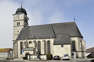
Gedersdorf Place in Lower Austria, Austria

Gedersdorf is a municipality in the district of Krems-Land in the Austrian state of Lower Austria.

Rohrendorf bei Krems Place in Lower Austria, Austria

Rohrendorf bei Krems is a municipality in the district of Krems-Land in the Austrian state of Lower Austria.

Edlbach Place in Upper Austria, Austria

Edlbach is a municipality in the district of Kirchdorf an der Krems in the Austrian state of Upper Austria.

Grünburg Place in Upper Austria, Austria

Grünburg is a municipality in the district of Kirchdorf an der Krems in the Austrian state of Upper Austria.

Inzersdorf im Kremstal Place in Upper Austria, Austria

Inzersdorf im Kremstal is a municipality in the district of Kirchdorf an der Krems in the Austrian state of Upper Austria.

Klaus an der Pyhrnbahn Place in Upper Austria, Austria

Klaus an der Pyhrnbahn is a municipality in the district of Kirchdorf an der Krems in the Austrian state of Upper Austria.

Oberschlierbach Place in Upper Austria, Austria

Oberschlierbach is a municipality in the district of Kirchdorf an der Krems in the Austrian state of Upper Austria.

Pettenbach Place in Upper Austria, Austria

Pettenbach is a municipality in the district of Kirchdorf an der Krems in the Austrian state of Upper Austria.

Roßleithen Place in Upper Austria, Austria

Roßleithen is a municipality in the district of Kirchdorf an der Krems in the Austrian state of Upper Austria.

Rosenau am Hengstpaß Place in Upper Austria, Austria

Rosenau am Hengstpaß is a municipality in the district of Kirchdorf an der Krems in the Austrian state of Upper Austria.

Spital am Pyhrn Place in Upper Austria, Austria

Spital am Pyhrn is a municipality in the district of Kirchdorf an der Krems in the Austrian state of Upper Austria.

Sankt Pankraz Place in Upper Austria, Austria

Sankt Pankraz is a municipality in the district of Kirchdorf an der Krems in the Austrian state of Upper Austria.

Steinbach am Ziehberg Place in Upper Austria, Austria

Steinbach am Ziehberg is a municipality in the district of Kirchdorf an der Krems in the Austrian state of Upper Austria.

Vorderstoder Place in Upper Austria, Austria

Vorderstoder is a municipality in the district of Kirchdorf an der Krems in the Austrian state of Upper Austria.

Wartberg an der Krems Place in Upper Austria, Austria

Wartberg an der Krems is a municipality in the district of Kirchdorf an der Krems in the Austrian state of Upper Austria.

Neuhofen an der Krems Place in Upper Austria, Austria

Neuhofen an der Krems is a municipality in the district Linz-Land in the Austrian state of Upper Austria.

Schiedlberg Place in Upper Austria, Austria

Schiedlberg is a municipality in the district of Steyr-Land in the Austrian state of Upper Austria.

References

  1. "Dauersiedlungsraum der Gemeinden Politischen Bezirke und Bundesländer - Gebietsstand 1.1.2018". Statistics Austria. Retrieved 10 March 2019.
  2. "Einwohnerzahl 1.1.2018 nach Gemeinden mit Status, Gebietsstand 1.1.2018". Statistics Austria. Retrieved 9 March 2019.