Rom, Germany

Last updated
Rom
Paarsch Kirche 2008-04-28 063.jpg
Church in Paarsch
Location of Rom within Ludwigslust-Parchim district
Rom (Mecklenburg) in LUP.svg
Germany adm location map.svg
Red pog.svg
Rom
Mecklenburg-Vorpommern location map.svg
Red pog.svg
Rom
Coordinates: 53°27′N11°55′E / 53.450°N 11.917°E / 53.450; 11.917
Country Germany
State Mecklenburg-Vorpommern
District Ludwigslust-Parchim
Municipal assoc. Parchimer Umland
Subdivisions6
Government
   Mayor Horst Klawuhn
Area
  Total33.60 km2 (12.97 sq mi)
Elevation
58 m (190 ft)
Population
 (2022-12-31) [1]
  Total804
  Density24/km2 (62/sq mi)
Time zone UTC+01:00 (CET)
  Summer (DST) UTC+02:00 (CEST)
Postal codes
19372
Dialling codes 038731
Vehicle registration PCH
Website www.amt-parchimer-umland.de

Rom is a municipality in the Ludwigslust-Parchim district, in Mecklenburg-Vorpommern, Germany.

Contents

Geography and transport

The municipality is located 7 km east of Parchim and seven kilometers west of Lübz. The Bundesstraße 191 runs through the community. The Bundesautobahn 24 can be reached via the Parchim junction, which is 18 km away from Rom. The municipality is bordered by the Müritz-Elde waterway in the south. The Darzer Hochmoor and the Wockertal are found in the northern part. Rom had a stop on the Mecklenburg Southern Railway, the Haltepunkt Rom (Meckl).

The municipality of Rom includes the villages of Darze, Klein Niendorf, Lancken, Paarsch, Rome and Stralendorf. [2]

History

Lancken, as the oldest village of the municipality of Rom, was first mentioned in 1229 in a document. [3] From a former Meierhof (around 1700) of the estate of Greven emerged an estate of the families of Hammerstein (from 1800) of Soden (1806), Knights of Henckel (after 1824) and of the families Blanck, Stucken and until 1945, Wesendorf. In 1830, the old manor house was demolished; under the Blanck family, the still existing mansion, a brick building with hipped roof, was completed in 1846. From 1960 onwards it served as a school, from 1984 onwards it was a children's holiday home, and it is now privately owned. [4]

Name

Rom was called villa Rome in 1310, Roma in 1320, Rome in 1329, and Rohm in 1621. The name comes from the Polabian language and refers to the Lokator: Ort des Rom ("Rom's place"). [5] [6]

Merger of municipalities

On January 1, 1951, Stralendorf was incorporated into Darze. On the same day, Lancken became part of the municipality of Rom.

On June 13, 2004, Stralendorf was incorporated into Rom. [7]

Related Research Articles

<span class="mw-page-title-main">Lübtheen</span> Town in Mecklenburg-Vorpommern, Germany

Lübtheen is a municipality in the Ludwigslust-Parchim district, in Mecklenburg-Western Pomerania, Germany. It is situated 28 km west of Ludwigslust, and 37 km southwest of Schwerin. It is part of the Hamburg Metropolitan Region.

<span class="mw-page-title-main">Balow</span> Municipality in Mecklenburg-Vorpommern, Germany

Balow is a municipality in the Ludwigslust-Parchim district, in Mecklenburg-Vorpommern, Germany.

<span class="mw-page-title-main">Besitz</span> Municipality in Mecklenburg-Vorpommern, Germany

Besitz is a municipality in the Ludwigslust-Parchim district, in Mecklenburg-Vorpommern, Germany.

<span class="mw-page-title-main">Möllenbeck, Ludwigslust</span> Municipality in Mecklenburg-Vorpommern, Germany

Möllenbeck is a municipality in the Ludwigslust-Parchim district, in Mecklenburg-Vorpommern, Germany.

<span class="mw-page-title-main">Kirch Jesar</span> Municipality in Mecklenburg-Vorpommern, Germany

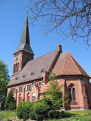
Kirch Jesar is a municipality in the Ludwigslust-Parchim district, in Mecklenburg-Vorpommern, Germany. The village was first mentioned in 1371.

<span class="mw-page-title-main">Pampow</span> Municipality in Mecklenburg-Vorpommern, Germany

Pampow is a municipality in the Ludwigslust-Parchim district, in Mecklenburg-Vorpommern, Germany.

<span class="mw-page-title-main">Rastow</span> Municipality in Mecklenburg-Vorpommern, Germany

Rastow is a municipality in the Ludwigslust-Parchim district, in Mecklenburg-Vorpommern, Germany.

<span class="mw-page-title-main">Redefin</span> Municipality in Mecklenburg-Vorpommern, Germany

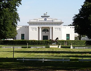
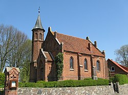
Redefin is a municipality in the Ludwigslust-Parchim district, in Mecklenburg-Vorpommern, Germany.

<span class="mw-page-title-main">Wittendörp</span> Municipality in Mecklenburg-Vorpommern, Germany

Wittendörp is a municipality in the administrative district of Ludwigslust-Parchim in Mecklenburg-Vorpommern, Germany. The municipality has a seat in the Amt of Wittenburg from where it is administered. The municipality is about 25 kilometres west of Schwerin in the north of the administrative district Ludwigslust-Parchim and borders on the administrative district of Nordwestmecklenburg in the north. The river Schilde flows through the municipality.

<span class="mw-page-title-main">Fincken</span> Municipality in Mecklenburg-Vorpommern, Germany

Fincken is a municipality in the Mecklenburgische Seenplatte district, in Mecklenburg-Vorpommern, Germany.

<span class="mw-page-title-main">Dobin am See</span> Municipality in Mecklenburg-Vorpommern, Germany

Dobin am See is a municipality in the Ludwigslust-Parchim district, in Mecklenburg-Vorpommern, Germany.

<span class="mw-page-title-main">Nieden</span> Municipality in Mecklenburg-Vorpommern, Germany

Nieden is a municipality in the Vorpommern-Greifswald district, in Mecklenburg-Vorpommern, Germany.

<span class="mw-page-title-main">Jatznick</span> Municipality in Mecklenburg-Vorpommern, Germany

Jatznick is a municipality in the Vorpommern-Greifswald district, in Mecklenburg-Vorpommern in north-eastern Germany.

<span class="mw-page-title-main">Lancken-Granitz</span> Municipality in Mecklenburg-Vorpommern, Germany

Lancken-Granitz is a municipality in the Vorpommern-Rügen district, in Mecklenburg-Vorpommern, Germany. Near the villages of Lancken and Burtevitz are several megalith tombs from the Neolithic.

Ludwigslust-Parchim is a district in the west of Mecklenburg-Vorpommern, Germany. The district seat is Parchim, a branch office of the administration is located in Ludwigslust.

West Mecklenburg is the western part of the German federal state of Mecklenburg-Vorpommern, covering an area of ca. 7,000 km². It incorporates parts of the historic territories of Mecklenburg-Schwerin and Mecklenburg-Strelitz and of Saxe-Lauenburg.

Pribislaw II was a prince from the Parchim-Richenberg line of the House of Mecklenburg. He was Lord of Białogard from 1270 until his death.

<span class="mw-page-title-main">Gehlsbach</span> Municipality in Mecklenburg-Vorpommern, Germany

Gehlsbach is a municipality in the Ludwigslust-Parchim district of Mecklenburg-Vorpommern, Germany. It was formed on 1 January 2014 by the merger of the former municipalities of Karbow-Vietlübbe and Wahlstorf.

Friedrich Wigger was a north German archivist. During the second half of the nineteenth century he served as archivist in charge of the "Großherzogliche Geheime und Hauptarchiv Schwerin in Mecklenburg", the precursor to the Central State Archive of Mecklenburg-Vorpommern. Wigger was also a local historian and genealogist, noted in particular for his "Stammtafeln des Großherzoglichen Hauses von Meklenburg".

Hans-Joachim Griephan is a German journalist, publisher and founder of the "Wirtschaftsinformationsdienst" published since 1964, the Griephan Briefe.

References

  1. "Bevölkerungsstand der Kreise, Ämter und Gemeinden 2022" (XLS) (in German). Statistisches Amt Mecklenburg-Vorpommern. 2023.
  2. § 1 der Archived 2014-02-01 at the Wayback Machine der Gemeinde.
  3. MUB I. (1863) Nr. 370. 1229. Juni 4. Parchim. Johann, Fürst von Meklenburg, bekennt, in den Dörfern Damm, Klokow, Lanken und Möderitz dem Kirchspiel Parchim 4 Capellen errichtet, und zur Entschädigung des Pfarrers zu Parchim die BurgCapelle daselbst mit 6 Hufen in Bök, welche Gerard von Malin geschenkt hatte, bewidmet zu haben.
  4. Gutshaus Lancken bei www.gutshaeuser.de
  5. Paul Kühnel: Die slavischen Ortsnamen in Meklenburg. In: MJB Bd. 46 (1881) S. 3–168.
  6. Siering, Waldemar; Siering, Robert (April 17, 2013). Orte mit kuriosen Namen in Mecklenburg-Vorpommern: Von Aalbude bis Zitterpenningshagen. Steffen Verlag. ISBN   9783942477482 via Google Books.
  7. Gebietsänderungen vom 01.01. bis 31.12.2004, Statistisches Bundesamt