Romny

Last updated • 4 min readFrom Wikipedia, The Free Encyclopedia

50°45′N33°28′E / 50.750°N 33.467°E / 50.750; 33.467

Contents

Romny
Ромни
Romny Bank 00 Soborna (Lenina) 1 (YDS 4615).JPG
Former bank building in Romny
FLA Romny, Sumska, Ukraine.svg
COA Romny, Sumska, Ukraine.svg
Ukraine adm location map improved.svg
Red pog.svg
Romny
Sumskaya oblast location map.svg
Red pog.svg
Romny
Coordinates: 50°45′N33°28′E / 50.750°N 33.467°E / 50.750; 33.467
Country Flag of Ukraine.svg  Ukraine
Oblast Sumy Oblast
Raion Romny Raion
Hromada Romny urban hromada
First mentioned1096
City rights1781
Area
  Total
65 km2 (25 sq mi)
Elevation
171 m (561 ft)
Population
 (2022)
  Total
37,765
Website http://forum.romny.info/

Romny (Ukrainian : Ромни, IPA: [romˈnɪ] ) is a city in Sumy Oblast, northern Ukraine. It is located on the Romen River. Romny serves as the administrative centre of Romny Raion and hosts the administration of Romny urban hromada  [ uk ], one of the hromadas of Ukraine. Population: 37,765 (2022 estimate). [1]

History

Soviet-era coat of arms Romny Coat of Arms.png
Soviet-era coat of arms
2001-2015 flag Flag of Romny.png
2001-2015 flag

The city was founded in AD 902. On September 16, 2002, the city celebrated its 1,100th anniversary. Romny was first mentioned in documents in 1096 (as Romen, Cyrillic : Ромен; the name, originally that of the river, is of Baltic origin, cf. Lithuanian romus 'quiet' [2] ). At various times, it passed under Mongol, Lithuanian, Polish and Russian rule. By 1638, the city had a population of 6,000 inhabitants, which made it by far the largest settlement in the area. In 1781, the city was granted a charter by the Tsarina Catherine II.

Romny was the terminus of the Libau-Romny railway which was built to deliver Ukrainian goods, mostly grains, for export. It also served as main route for emigration to the Americas through the Libau post where passenger ships were accessed.

In Romny the first statue of Taras Shevchenko was erected on 27 October 1918 when the city was located in the newly established Ukrainian state. It was preserved as part of the Soviet Union Ukrainization policies. [3]

Unimaginable suffering was inflicted on the people of Romny during the years of Bolshevik rule, two world wars, famines, and repressions. [4] During the Holodomor of 1932–1933, organized by the Soviet authorities, at least 2274 residents of the city died.

The concrete statue in Romny began to decay in the 1950s, but was remade in bronze and re-unveiled in 1982. [3] The original version of the monument is located on Kyiv's Andriyivskyy Descent. [3]

During World War II, Romny was occupied by the German Army from September 10, 1941, to September 16, 1943. The Germans operated a Nazi prison in the city. [5]

In the period between 1979 and 1989, Romny's population rose from 53,016 to 57,502 inhabitants.

In 2022, a series of military engagements occurred near Romny during the 2022 Russian invasion of Ukraine.

Population

Ethnicity

According to the 2001 Ukrainian census, the city had a population of 49,935 inhabitants. The ethnic composition was as follows: [6]

Ethnic groups in Romny
percent
Ukrainians
93.68%
Russians
5.42%
Belarusians
0.70%
others
0.16%

Language

Distribution of the population by native language according to the 2001 census: [7]

LanguagePercentage
Ukrainian 93.95%
Russian 5.70%
other/undecided0.35%

Geography

Climate

Climate data for Romny (1991–2020)
MonthJanFebMarAprMayJunJulAugSepOctNovDecYear
Mean daily maximum °C (°F)−2.1
(28.2)
−0.7
(30.7)
5.2
(41.4)
14.6
(58.3)
21.1
(70.0)
24.4
(75.9)
26.3
(79.3)
25.8
(78.4)
19.6
(67.3)
12.2
(54.0)
4.2
(39.6)
−0.8
(30.6)
12.5
(54.5)
Daily mean °C (°F)−4.6
(23.7)
−3.9
(25.0)
1.1
(34.0)
9.2
(48.6)
15.2
(59.4)
18.8
(65.8)
20.6
(69.1)
19.6
(67.3)
14.0
(57.2)
7.6
(45.7)
1.4
(34.5)
−3.0
(26.6)
8.0
(46.4)
Mean daily minimum °C (°F)−7.2
(19.0)
−6.8
(19.8)
−2.4
(27.7)
4.3
(39.7)
9.6
(49.3)
13.5
(56.3)
15.3
(59.5)
14.0
(57.2)
9.1
(48.4)
3.9
(39.0)
−0.9
(30.4)
−5.3
(22.5)
3.9
(39.0)
Average precipitation mm (inches)49
(1.9)
40
(1.6)
45
(1.8)
37
(1.5)
57
(2.2)
70
(2.8)
76
(3.0)
42
(1.7)
54
(2.1)
45
(1.8)
41
(1.6)
49
(1.9)
605
(23.8)
Average precipitation days (≥ 1.0 mm)9.98.48.97.08.58.58.75.67.37.57.48.996.6
Average relative humidity (%)85.182.176.365.865.969.271.668.474.380.286.987.676.1
Source: NOAA [8]

Sights

The cathedral of the Holy Spirit, founded in 1735 in place of a wooden church, is a four-pillared cathedral designed in the Ukrainian Baroque style and is surmounted by three pear-shaped domes, each placed on a tall cylinder. Although the cathedral dates back to the 1740s, the building of the nearby belfry and winter church was not undertaken until 1780.

Another noteworthy building is the church of the Ascension, which also has three domes, but was constructed later, in 1795–1801, and adjoins a Baroque belfry built in 1753–63.

Local government

Beside the city itself, the city municipality also serves as government for a village Kolisnykove and a settlement Luchky.

The city also has administration of the surrounding Romny Raion.

Notable people

Related Research Articles

<span class="mw-page-title-main">Kaniv</span> City in Cherkasy Oblast, Ukraine

Kaniv is a city in Cherkasy Raion, Cherkasy Oblast, central Ukraine. The city rests on the Dnieper River, and is one of the main inland river ports on the Dnieper. It is an urban hromada of Ukraine. Population: 23,172.

<span class="mw-page-title-main">Cherkasy Oblast</span> Oblast (region) of Ukraine

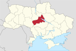
Cherkasy Oblast, also referred to as Cherkashchyna is an oblast (province) in central Ukraine located along the Dnieper River. The administrative center of the oblast is the city of Cherkasy. The current population of the oblast is 1,160,744.

<span class="mw-page-title-main">Mykolaiv, Lviv Oblast</span> City in Lviv Oblast, Ukraine

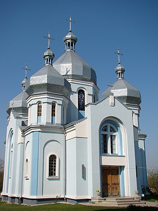
Mykolaiv is a city in Stryi Raion, Lviv Oblast (region) in western Ukraine. It hosts the administration of Mykolaiv urban hromada, one of the hromadas of Ukraine. The population is approximately 14,498.

<span class="mw-page-title-main">Reni, Ukraine</span> City in Odesa Oblast, Ukraine

Reni is a small city in Izmail Raion, Odesa Oblast, southern Ukraine. It hosts the administration of Reni urban hromada, one of the hromadas of Ukraine. Reni is located in the Bessarabian historic district of Budjak and on the left bank of the Danube. The settlement was founded around 1548, acquiring city status in 1821. Population: 17,736.

<span class="mw-page-title-main">Izmail</span> City in Odesa Oblast, Ukraine

Izmail is a city and municipality on the Danube river in Odesa Oblast in south-western Ukraine. It serves as the administrative center of Izmail Raion, one of seven districts of Odesa Oblast, and is the only locality which constitutes Izmail urban hromada, one of the hromadas of Ukraine.

<span class="mw-page-title-main">Lubny</span> City in Poltava Oblast, Ukraine

Lubny is a city in Poltava Oblast, central Ukraine. It serves as the administrative center of Lubny Raion. It also hosts the administration of Lubny urban hromada, one of the hromadas of Ukraine. Population: 44,089.

<span class="mw-page-title-main">Kozelets</span> Rural locality in Chernihiv Oblast, Ukraine

Kozelets is a rural settlement in Chernihiv Raion, Chernihiv Oblast, northern Ukraine. It hosts the administration of Kozelets settlement hromada, one of the hromadas of Ukraine. Kozelets is located on the Oster River, a tributary of the Dnieper. Population: 7,496.

<span class="mw-page-title-main">Zolotonosha</span> Town in Cherkasy Oblast, Ukraine

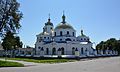
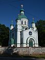
Zolotonosha is a city located in Cherkasy Oblast (region) in central Ukraine. Located at around 49°40′N32°2′E, the city serves as the administrative center of Zolotonosha Raion (district). It hosts the administration of Zolotonosha urban hromada, one of the hromadas of Ukraine. Population: 27,206.

<span class="mw-page-title-main">Bakhmach</span> Urban locality in Chernihiv Oblast, Ukraine

Bakhmach is a city located in Nizhyn Raion of Chernihiv Oblast (province), in northern Ukraine. It hosts the administration of Bakhmach urban hromada, one of the hromadas of Ukraine. It has a population of 16,862.

<span class="mw-page-title-main">Pokrov, Ukraine</span> City in Dnipropetrovsk Oblast, Ukraine

Pokrov, formerly Ordzhonikidze (Орджонікідзе) until 2016, is a small city and mining town in Nikopol Raion, Dnipropetrovsk Oblast, central Ukraine. It hosts the administration of Pokrov urban hromada, one of the hromadas of Ukraine. Its population is approximately 37,493.

<span class="mw-page-title-main">Karlivka</span> City in Poltava Oblast, Ukraine

Karlivka is a city in Poltava Raion, Poltava Oblast, Ukraine. It hosts the administration of Karlivka urban hromada, one of the hromadas of Ukraine. Population: 14,045.

Hlobyne is a city in Kremenchuk Raion, Poltava Oblast, Ukraine. It hosts the administration of Hlobyne urban hromada, one of the hromadas of Ukraine. Population: 8,955.

Vyshneve is a city in Bucha Raion, Kyiv Oblast, Ukraine, located two kilometres (1.2 mi) south of the capital Kyiv. Vyshneve hosts the administration of Vyshneve urban hromada, one of the hromadas of Ukraine. It has a population of 42,983.

<span class="mw-page-title-main">Znamianka, Kirovohrad Oblast</span> City in Kirovohrad Oblast, Ukraine

Znamianka is a city in central Ukraine, Kropyvnytskyi Raion, Kirovohrad Oblast. It hosts the administration of Znamianka urban hromada, one of the hromadas of Ukraine. Population: 21,221.

<span class="mw-page-title-main">Bobrynets</span> City in Kirovohrad Oblast, Ukraine

Bobrynets is a city in Kropyvnytskyi Raion, Kirovohrad Oblast, Ukraine. It hosts the administration of Bobrynets urban hromada, one of the hromadas of Ukraine. Population: 10,396.

<span class="mw-page-title-main">Borodianka</span> Rural locality in Kyiv Oblast, Ukraine

Borodianka is a rural settlement in Bucha Raion, Kyiv Oblast, Ukraine. It hosts the administration of Borodianka settlement hromada, one of the hromadas of Ukraine. Population: 13,832. According to the 2001 census, its population was 12,535.

<span class="mw-page-title-main">Kozova</span> Rural locality in Ternopil Oblast, Ukraine

Kozova is a rural settlement in Ternopil Raion, Ternopil Oblast, western Ukraine. It is located in the historical region of Galicia, 16 km (10 mi) east of Berezhany, some 30 km (19 mi) west of Ternopil, and 100 km (62 mi) southeast of Lviv. It hosts the administration of Kozova settlement hromada, one of the hromadas of Ukraine. The settlement is situated beside a lake on the Koropets River. There is presumption that the name Kozova comes from the Ukrainian word koza (goat), though other possible sources exist. Population: 8,750.

Kuriany is a village of 831 people in Ternopil Raion (district) of Ternopil Oblast (province) in western Ukraine. Kuriany is situated on both sides of the Narayivka River, in a valley surrounded by hills covered with thick forests on both sides. The main Ternopil-Stryi highway runs through town. Kuriany belongs to Naraiv rural hromada, one of the hromadas of Ukraine.

<span class="mw-page-title-main">Stratyn</span> Rural locality in Ivano-Frankivsk Oblast, Ukraine

Stratyn is a village and rural municipality in western Ukraine. It lies in Ivano-Frankivsk Raion of Ivano-Frankivsk Oblast of Ukraine, in the centre of the historic area of Halychyna, formerly in Austrian empire (1772–1918), Poland and USSR. The current population is 561 inhabitants. The old name of the village was Striatyn. Stratyn belongs to Rohatyn urban hromada, one of the hromadas of Ukraine.

<span class="mw-page-title-main">Dmytrivka, Chernihiv Oblast</span> Rural locality in Chernihiv Oblast, Ukraine

Dmytrivka is a rural settlement in Nizhyn Raion, Chernihiv Oblast, Ukraine. It hosts the administration of Dmytrivka settlement hromada, one of the hromadas of Ukraine. Population is 2,090.

References

  1. Чисельність наявного населення України на 1 січня 2022 [Number of Present Population of Ukraine, as of January 1, 2022](PDF) (in Ukrainian and English). Kyiv: State Statistics Service of Ukraine. Archived (PDF) from the original on 4 July 2022.
  2. E.M. Pospelov, Geograficheskie nazvaniya mira (Moscow, 1998), p. 355.
  3. 1 2 3 (in Ukrainian) 100 years ago the first monument to Taras Shevchenko was built for the Hetmanate, Radio Svoboda (14 October 2018)
  4. https://web.archive.org/web/20160304083319/http://shron.chtyvo.org.ua/Piatachenko_Serhii/Holodomor_na_Sumschyni_u_spohadakh_ochevydtsiv_Knyha_2.pdf. Archived from the original (PDF) on 2016-03-04. Retrieved 2023-12-07.{{cite web}}: Missing or empty |title= (help)
  5. "Gefängnis Romny". Bundesarchiv.de (in German). Retrieved 26 February 2022.
  6. "Національний склад міст". Datatowel.in.ua (in Ukrainian). Retrieved 2024-08-25.
  7. "Рідні мови в об'єднаних територіальних громадах України".
  8. "World Meteorological Organization Climate Normals for 1991-2020 — Romny". National Oceanic and Atmospheric Administration. Retrieved June 16, 2024.