
Sherman County is one of the 36 counties in the U.S. state of Oregon. As of the 2020 census, the population was 1,870, making it the second-least populous county in Oregon after nearby Wheeler. The county seat is Moro, and the largest city is Wasco. The county is named for William Tecumseh Sherman, a Union general in the American Civil War.

Shaniko is a city located in Wasco County, Oregon, United States, on U.S. Route 97 and about 8 miles (13 km) north of Antelope. The population was 30 at the 2020 census.

Gleeson is a ghost town situated in southeastern Cochise County, Arizona, United States. It has an estimated elevation of 4,924 feet (1,501 m) above sea level. The town was first settled as Turquoise in the 1870s in what was then the Arizona Territory, then later re-established as Gleeson in 1900.
Cochran is a ghost town in Pinal County in the U.S. state of Arizona. The town was settled in 1905, in what was then the Arizona Territory.
Allen, also known as Allen City is a ghost town in Pima County in southern Arizona. It was founded fifty miles southeast of Ajo, c. 1880. By 1886, the post office closed and the town has been abandoned since.
Cerbat is a ghost town just west of the Cerbat Mountains in Mohave County, Arizona, United States. Mining in the area began in the late 1860s and a camp was established soon after. Cerbat was built in a canyon 38 miles (61 km) from Hardyville. The town was prosperous and contained several mining and public buildings, along with cabins for over 100 settlers, as well as a school, a doctor's office and a lawyer's office. In the 1870s the town was connected by dirt road to Fort Rock, Camp Hualapai and Prescott. Cerbat was the third seat of Mohave County until 1877 when Mineral Park took the title.
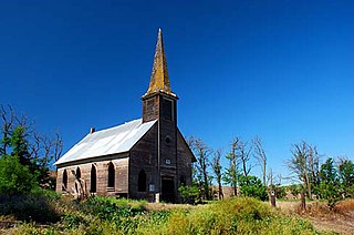
Locust Grove is an unincorporated community and ghost town in Sherman County, Oregon, United States. It is located on Oregon Route 206, six miles west of Wasco.
Sherman most commonly refers to:
Pactola, also known as Camp Crook, (1875–1950s) is a ghost town in Pennington County, South Dakota, United States. It was an early placer mining town and existed into the early 1950s, when it was submerged under Pactola Lake.

Twin Buttes is a populated place on the east flank of the Sierrita Mountains approximately twenty miles south of Tucson, in Pima County, Arizona, United States. Named after a prominent hill located next to the town, Twin Buttes was founded as a small mining town circa 1903 and abandoned around 1930. Much of the actual town site is now buried underneath mine tailings, and all that remains is the Twin Buttes Cemetery.
DeNoon is a ghost town located 13 miles (21 km) southwest of Superior in Pinal County, Arizona, United States. The town served as a milling town for the Reymert Mine, which was 2 miles (3.2 km) away. James DeNoon Reymert founded and named the town in 1889. The town grew quickly, and its own post office opened on March 19, 1890; however, the post office closed the following year, and the town disappeared soon afterwards.
Blalock was an unincorporated community located in the Columbia River Gorge in Gilliam County, Oregon, United States. The town displaced a Native American settlement originally named Táwash. Blalock was located about 7 miles (11 km) west of Arlington on Interstate 84/U.S. Route 30 at the mouth of Blalock Canyon. Blalock is still the name of a station on the Union Pacific Railroad.
Constellation is a former mining town in Yavapai County, Arizona, United States. It has an estimated elevation of 3,560 feet (1,090 m) above sea level. The town was started to support the Monte Cristo Mine, which was later joined by several other mines. In 1925 the town had a post office and some 250 residents, but no trace of it is left, though ruins of the various mines surround the ghost town site.
Early is a former community in Sherman County, Oregon, United States. It was located on the western bank of the John Day River about 5 miles up river to what is now La Page Park along Interstate 84. It was founded in 1902, with a post office established at this time. The post office was discontinued in 1919. In the 20th century, a flour mill operated in the town. It is contemporarily considered a ghost town.
Fargher is a former community in Sherman County, Oregon, United States. It was founded by Arthur W. Fargher, a native of the Isle of Man, who arrived in Oregon in 1878. The community's rail station was located near the Sherars Bridge. It is contemporarily considered a ghost town.
Gordon is a former community in Sherman County, Oregon, United States. It was first settled in 1875 by Tom Gordon, an Irish immigrant, and formally established with a post office in 1896, which only operated from July to December that year before closing. Gordon is contemporarily considered a ghost town.
Gorman is a former community in Sherman County, Oregon, United States, established in 1892. Its post office opened August 25, 1892, and operated for eight years before closing in 1900. Gorman is contemporarily considered a ghost town.
Miller is a former community in Sherman County, Oregon, United States, established circa 1860. It was named for Thomas Jefferson Miller, a settler of the area, also for which Miller Island on the Columbia River takes its name. Miller is contemporarily considered a ghost town.
Thornberry is a former community in Sherman County, Oregon, United States, founded in 1916. Formerly known as Grebe, Thornberry was named for Harvey B. Thornberry, who became the second postmaster in January 1919. The town post office was officially closed in November 1923. Thornberry is contemporarily considered a ghost town.


