
Bly is an unincorporated community in Klamath County, Oregon, United States. By highway, it is about 50 miles (80 km) east of Klamath Falls. As of 2020, the population was 207.
Riley is an unincorporated community in Harney County, Oregon, United States, located at the crossroads of U.S. Highway 395 and U.S. Highway 20, milepost 104, about 28 miles (45 km) west of Burns, the seat of Harney County. The elevation of Riley is 4,226 feet (1,288 m). The town presently consists entirely of two service establishments with attached apartments: a post office, and a general store with gas pump and garage service. It exists to serve the rural farming and ranching community that surrounds it, and highway travelers.

Camp Sherman is an unincorporated community and census-designated place (CDP) in Jefferson County, Oregon, United States. It is located on the Metolius River. The year-round population as of the 2010 census was 233, with that number tripling or more during the summer. The community includes an elementary school, Black Butte School, a general store and a post office. The community also has a volunteer fire department. Camp Sherman was founded by vacationers from Sherman County in the latter part of the 19th century.

Corbett is an unincorporated community on the Columbia River in eastern Multnomah County, Oregon, United States. It is located on the Historic Columbia River Highway between the Sandy River and Crown Point.
Rome, also called Rome Station after its sole business, is an unincorporated community in Malheur County, Oregon, United States. It is part of the Ontario, OR–ID Micropolitan Statistical Area. In the sparsely populated high desert of southeastern Oregon, Rome is immediately west of the Owyhee River on U.S. Route 95, approximately 12 miles (19 km) northeast of Burns Junction. Jordan Creek enters the river slightly downstream of Rome. The elevation of Rome is 3,390 feet (1,033 m) above sea level.

Reedville is an unincorporated community in Washington County, Oregon, United States, located between Hillsboro and Aloha. Oregon Route 8 runs through the area. The community is served by the Hillsboro School District, with some portions of the area within the city limits of Hillsboro.

Deadwood is an unincorporated community in Lane County, Oregon, United States. It is located on Oregon Route 36, in the Oregon Coast Range.

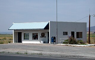
Crane is a census-designated place and unincorporated community in Harney County, Oregon, United States, northeast of Malheur Lake on Oregon Route 78. Its population was 116 at the 2020 census.
Marmot is an unincorporated community in Clackamas County, Oregon, United States located in the Mount Hood Corridor. It is within the boundaries of the Villages at Mount Hood, on a ridge known as Devil's Backbone, which lies between the Sandy and Little Sandy rivers, along the historic Barlow Road.

Roy is an unincorporated historical community in Washington County, Oregon, United States. It is located south of the Sunset Highway and southeast of the city of Banks.
Klondike is an unincorporated community in Sherman County, Oregon, United States. It is near the Wasco, Oregon site of the Klondike III Wind Project, Oregon's largest wind energy farm with 176 turbines for wind energy.

McDonald is an unincorporated community in Sherman County, Oregon, United States. Its post office was established on the John Day River on March 15, 1902, and closed on October 14, 1922. The first postmaster was William G. McDonald.

Narrows, or The Narrows, is an unincorporated community in Harney County, Oregon, United States. It was started as a community in 1889 by Lewis B. Springer and Albert Hembree. A post office was established in August 1889 and Springer, the postmaster, named it after himself. In April 1892 the name was changed to Narrows and Hembree became postmaster. The post office operated until 1936, and is now served by the New Princeton post office, zip code 97721.
Bakeoven is an unincorporated community in Wasco County, in the U.S. state of Oregon. It is southeast of Maupin and northwest of Shaniko along Bakeoven Creek, a tributary of the Deschutes River.
Blalock was an unincorporated community located in the Columbia River Gorge in Gilliam County, Oregon, United States. The town displaced a Native American settlement originally named Táwash. Blalock was located about 7 miles (11 km) west of Arlington on Interstate 84/U.S. Route 30 at the mouth of Blalock Canyon. Blalock is still the name of a station on the Union Pacific Railroad.
Erskine is an unincorporated community in Sherman County, in the U.S. state of Oregon. It lies between Moro and Grass Valley along Erskine Road, west of U.S. Route 97.
Early is a former community in Sherman County, Oregon, United States. It was located on the western bank of the John Day River about 5 miles up river to what is now La Page Park along Interstate 84. It was founded in 1902, with a post office established at this time. The post office was discontinued in 1919. In the 20th century, a flour mill operated in the town. It is contemporarily considered a ghost town.
Gordon is a former community in Sherman County, Oregon, United States. It was first settled in 1875 by Tom Gordon, an Irish immigrant, and formally established with a post office in 1896, which only operated from July to December that year before closing. Gordon is contemporarily considered a ghost town.
Gorman is a former community in Sherman County, Oregon, United States, established in 1892. Its post office opened August 25, 1892, and operated for eight years before closing in 1900. Gorman is contemporarily considered a ghost town.
Thornberry is a former community in Sherman County, Oregon, United States, founded in 1916. Formerly known as Grebe, Thornberry was named for Harvey B. Thornberry, who became the second postmaster in January 1919. The town post office was officially closed in November 1923. Thornberry is contemporarily considered a ghost town.


