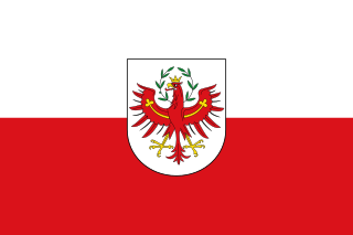
Tyrol is a state (Land) in western Austria. It comprises the Austrian part of the historical Princely County of Tyrol. It is a constituent part of the present-day Euroregion Tyrol–South Tyrol–Trentino. The capital of Tyrol is Innsbruck.

South Tyrol is an autonomous province in northern Italy, one of the two that make up the autonomous region of Trentino-Alto Adige/Südtirol. The province is the northernmost of Italy, the second largest, with an area of 7,400 square kilometres (2,857 sq mi) and has a total population of about 534,000 inhabitants as of 2021. Its capital and largest city is Bolzano.

Bolzano is the capital city of the province of South Tyrol in northern Italy. With a population of 108,245, Bolzano is also by far the largest city in South Tyrol and the third largest in historical Tyrol. The greater metro area has about 250,000 inhabitants and is one of the urban centers within the Alps.

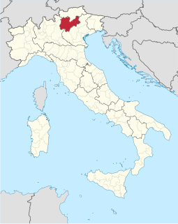
Trentino-Alto Adige/Südtirol is an autonomous region of Italy, located in the northern part of the country. The region has a population of 1.1 million, of whom 62% speak Italian as their native language, 30% speak South Tyrolean German, and several foreign languages are spoken by immigrant communities. Since the 1970s, most legislative and administrative powers have been transferred to the two self-governing provinces that make up the region: the Province of Trento, commonly known as Trentino, and the Province of Bolzano, commonly known as South Tyrol.
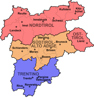
East Tyrol, occasionally East Tirol, is an exclave of the Austrian state of Tyrol, separated from the main North Tyrol part by the short common border of Salzburg and Italian South Tyrol. It is congruent with the administrative district (Bezirk) of Lienz.
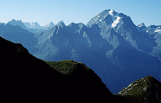
Trentino officially the Autonomous Province of Trento, is an autonomous province of Italy, in the country's far north. The Trentino and South Tyrol constitute the region of Trentino-Alto Adige/Südtirol, an autonomous region under the constitution. The province is composed of 177 comuni (municipalities). Its capital is the city of Trento (Trent). The province covers an area of more than 6,000 km2 (2,300 sq mi), with a total population of 541,098 in 2019. Trentino is renowned for its mountains, such as the Dolomites, which are part of the Alps.
Modern-day South Tyrol, an autonomous Italian province created in 1948, was part of the Austro-Hungarian County of Tyrol until 1918. It was annexed by Italy following the defeat of the Central Powers in World War I. It has been part of a cross-border joint entity, the Euroregion Tyrol-South Tyrol-Trentino, since 2001.
The Habicht is a mountain in the Stubai Alps of Austria. For a long time, the locals believed it to be the highest mountain in Tyrol, due to its prominence above the surrounding mountains. Despite what they thought, the highest peak in the Stubai Alps is Zuckerhütl which is 230 metres higher than Habicht. The name literally means "hawk" in German.
The (Princely) County of Tyrol was an estate of the Holy Roman Empire established about 1140. After 1253, it was ruled by the House of Gorizia and from 1363 by the House of Habsburg. In 1804, the county of Tyrol, unified with the secularised prince-bishoprics of Trent and Brixen, became a crown land of the Austrian Empire. From 1867, it was a Cisleithanian crown land of Austria-Hungary.

The Rosengarten group is a massif in the Dolomites of northern Italy. It is located between the Tierser Tal and Eggental in South Tyrol and the Fassa Valley in Trentino.

The Tyrol–South Tyrol–Trentino Euroregion is a Euroregion formed by three different regional authorities in Austria and Italy: the Austrian state of Tyrol and the Italian autonomous provinces of South Tyrol and Trentino.

The Feuerstein is a twin peak in the Stubai Alps on the border of Tyrol and South Tyrol.

The Grohmannspitze is a mountain in the Langkofel Group of the Dolomites in South Tyrol, Italy.
The Ohrenspitzen are three peaks on the border between Tyrol, Austria, and South Tyrol, Italy. They are a part of the Rieserferner Group in the Central Eastern Alps.
Tyrol is a historical region in the Alps—in Northern Italy and western Austria. The area was historically the core of the County of Tyrol, part of the Holy Roman Empire, Austrian Empire and Austria-Hungary, from its formation in the 12th century until 1919. In 1919, following World War I and the dissolution of Austria-Hungary, it was divided into two modern administrative parts through the Treaty of Saint-Germain-en-Laye:

The South Tyrolean independence movement is a political movement in the Italian autonomous province of South Tyrol that calls for the secession of the region from Italy and its reunification with the State of Tyrol, Austria. Concurrently, some groups favor the establishment of an interim Free State of South Tyrol as a sovereign nation while reintegration is organized.

The Patteriol is a mountain in the Verwall Alps in the Austrian state of Tyrol. It has an elevation of 3,056 m (AA). (In old literature the elevation is stated higher: 3,059 m or 10,037 ft. Patteriol is sometimes called "Matterhorn of Verwall" because of its shape.

The Wilde Leck is a mountain, 3,361 m (AA), in the Stubai Alps in the Austrian state of Tyrol. It rises immediately west of the Sulztalferner glacier and towers above the Ötztal valley, 5.5 km northwest of Sölden. It has a rocky summit made of solid granite and prominent arêtes. In the Stubai Alps the Wilde Leck is one of the most difficult summits to climb, because its easiest route runs initially over glaciers and then up a rock face that is assessed as climbing grade III (UIAA).

The Grabspitze, formerly also called the Hochferner, is the second highest peak in the Pfunderer Mountains after the Wilde Kreuzspitze (3,135 m). The Pfunderer are a subrange of the Zillertal Alps located in the Italian province of South Tyrol. Its former name, "Hochferner", was derived from a firn field that lay to the side of the summit.

The Tauernkogel is a mountain, 2,988 m (AA), in the Venediger Group of Austria's High Tauern. It lies west of the Felber Tauern and the border between the states of Salzburg and Tyrol runs over the summit. It may be climbed on a difficult mountain tour via a steep snowfield in about 1.½ hours from the St. Pöltner Hut.

