
Transportation in Israel is based mainly on private motor vehicles and bus service and an expanding railway network. A lack of inland waterways and the small size of the country make air and water transport of only minor importance in domestic transportation, but they are vitally important for Israel's international transport links. Demands of population growth, political factors, the Israel Defense Forces, tourism and increased traffic set the pace for all sectors, being a major driver in the mobility transition towards railways and public transit while moving away from motorized road transport. All facets of transportation in Israel are under the supervision of the Ministry of Transport and Road Safety.
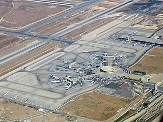
Ben Gurion International Airport, commonly known by the Hebrew-language acronym Natbag, is the main international airport of Israel. Situated on the northern outskirts of the city of Lod, it is the busiest airport in the country. It is located 45 kilometres (28 mi) to the northwest of Jerusalem and 20 kilometres (12 mi) to the southeast of Tel Aviv. Until 1973, it was known as Lod Airport, whereafter it was renamed in honour of David Ben-Gurion (1886–1973), the first Israeli prime minister. The airport serves as a hub for El Al, Israir Airlines, Arkia, and Sun d'Or, and is managed by the Israel Airports Authority.

Arkia, legally incorporated as Arkia Israeli Airlines Ltd, is an Israeli airline. Its head office is on the grounds of Sde Dov Airport in Tel Aviv, Israel. It is Israel's second-largest airline, operating scheduled domestic and international services, as well as charter flights to destinations in Western Europe and across the Mediterranean. Its main base is Ben Gurion Airport, with hub at Ramon Airport.

The CH-53 Sea Stallion is an American family of heavy-lift transport helicopters designed and built by the American manufacturer Sikorsky Aircraft. The Sea Stallion was originally developed in response to a request from the United States Navy's Bureau of Naval Weapons made in March 1962 for a replacement for the Sikorsky CH-37 Mojave helicopters flown by the United States Marine Corps (USMC).

Dov Hoz was a leader of the Labor Zionism movement, one of the founders of the Haganah organization, and a pioneer of Israeli aviation.

Sde Dov Airport, also known as Dov Hoz Airport(IATA: SDV, ICAO: LLSD) was an airport in Tel Aviv, Israel that mainly handled scheduled domestic flights to Eilat, northern Israel, as well as having served as a base for the Israeli Air Force (IAF). It was the largest airport in Tel Aviv proper, and the second largest in the area, after Ben Gurion Airport on the outskirts of Lod. The airport opened in 1938 and was named after Dov Hoz, one of the pioneers of Jewish aviation. It ceased operations on 30 June 2019 after a controversial, long-delayed plan came into effect to close the airport in order to build high-end residential apartments on its valuable beachfront property. Commercial flights were moved to Ben Gurion Airport and military flights were moved to other IAF bases. The airport was a focus city for Arkia Israel Airlines and Israir Airlines.
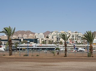
Eilat Airport, also known as J. Hozman Airport, was an airport located in Eilat, Israel. It was named after Arkia Airlines founder Yakov Hozman and was located in the center of Eilat adjacent to Route 90. Due to its short runway and limited capacity it mainly handled domestic flights from Tel Aviv and Haifa Airports, while Uvda International Airport, located some 60 km (40 mi) north of the city handled Eilat's international carriers.
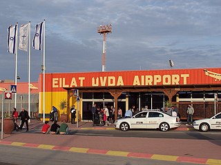
Ovda Airport was the former civilian part of the Ovda Israeli Air Force Base in the Uvda region of southern Israel, about 40 km (25 mi) north of Eilat. It was the country's second international airport. Ovda was originally built and opened as a military airbase in 1981 and was joint-used as a civilian airport a year later but ceased handling civilian flights on 31 March 2019 thanks to the opening of Ramon Airport, which is located much closer to the city of Eilat than Ovda.
Tamir Airways was an Israeli regional airline based in Tel Aviv.

Kiryat Shmona Airport is a public Israeli airport located 2 km east of the northern town of Kiryat Shmona. The airport is operated by Kiryat Shmona Travellers Inc.

The 1997 Israeli helicopter disaster occurred on February 4, 1997, when two Israeli Air Force transport helicopters ferrying Israeli soldiers into Israel's security zone in southern Lebanon collided in mid-air, killing all 73 Israeli military personnel on board. The crash brought about widespread national mourning and is considered a leading factor in Israel's decision to withdraw from southern Lebanon in 2000.

The Sikorsky CH-53K King Stallion is a heavy-lift cargo helicopter designed and produced by Sikorsky Aircraft. The King Stallion is an evolution of the long running CH-53 series of helicopters which have been in continuous service since 1966, and features three uprated 7,500 shp (5,590 kW) engines, new composite rotor blades, and a wider aircraft cabin than its predecessors. It is the largest and heaviest helicopter in the U.S. military.
Palmachim Airbase is an Israeli Air Force (IAF) base and spaceport located near the city of Yavne on the Mediterranean coast, 12 km south of Tel Aviv. It is named after the nearby Kibbutz Palmachim.
Elrom Airways was an airline based in Tel Aviv, Israel. It operated domestic scheduled flights from Sde Dov Airport, Tel Aviv to Ein Yahav Airfield.

The 118 Squadron is an active helicopter squadron of the Israeli Air Force and is part of the Participation & Helicopter Group, based at Tel Nof Airbase.Established on October 1970 and nicknamed the "Night Birds", also known as the "Night Riders" and the "Nocturnal Birds of Pray", the squadron is operating the Sikorsky CH-53-2025 Yas'ur.

On 26 July 2010, an Israeli Air Force Sikorsky CH-53 Yas'ur helicopter crashed during a training flight in the Carpathian Mountains, near the city of Brașov in Romania. The accident took place during a joint Romanian-Israeli aviation military exercise code-named "Blue Sky 2010".


