
Testerton is a small village and former civil parish, now in the parish of Pudding Norton, in the North Norfolk district, in the county of Norfolk, England. It is located between the village of Great Ryburgh and the market town of Fakenham. In 1931 the parish had a population of 53.

Morningthorpe is a village and former civil parish, now in the parish of Morningthorpe and Fritton in the South Norfolk district, in the county of Norfolk, England. It is situated some 20 kilometres (12 mi) south of the city of Norwich. The parish includes the villages of Morningthorpe and Fritton. The two villages are 1 km apart

Thurgarton is a village and former civil parish, now in the parish of Aldborough and Thurgarton, in the North Norfolk district of the county of Norfolk, England. It lies 6½ miles north of Aylsham and 5½ miles south-west of Cromer, and was once part of the North Erpingham hundred. In 1931 the parish had a population of 186.

West Newton is a village and former civil parish, now in the parish of Sandringham, in the King's Lynn and West Norfolk district, in the north of the county of Norfolk, England. The village is 1 kilometre (0.62 mi) south of Sandringham, 11 kilometres (7 mi) north of the town of King's Lynn and 60 kilometres (37 mi) north-west of the city of Norwich. In 1931 the parish had a population of 198.

Wolferton is a village and former civil parish, now in the parish of Sandringham, in the King's Lynn and West Norfolk district, in the county of Norfolk, England. It is 2 miles west of Sandringham, 7½ miles north of King's Lynn and 37¼ miles northwest of Norwich. In 1931 the parish had a population of 185. On 1 April 1935 the parish was abolished and merged with Sandringham.
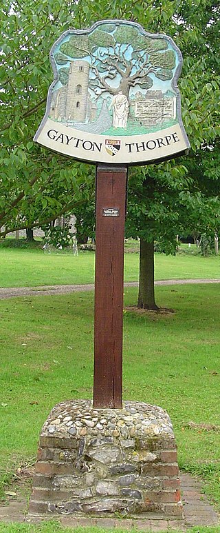
Gayton Thorpe is a village and former civil parish, now in the parish of Gayton, in the King's Lynn and West Norfolk district, in the county of Norfolk, England. The village is located 7.1 miles (11.4 km) south-east of King's Lynn and 31 miles (50 km) north-west of Norwich. In 1931 the parish had a population of 136.

Worthing is a small village and former civil parish, now in the parish of Hoe and Worthing, in the Breckland district, in the county of Norfolk, England. The civil parish of Worthing is now merged with that of the neighbouring village of Hoe, though the ecclesiastical parishes are still separate. In 1931 the parish had a population of 120. On 1 April 1935 Worthing was abolished and merged with Hoe, the renamed parish is now called "Hoe and Worthing".

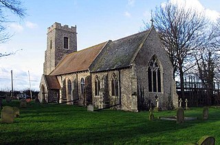
Tatterford is a village and former civil parish, now in the parish of Tattersett, in the North Norfolk district, in the county of Norfolk, England. The village is 4.8 miles south west of the town of Fakenham, 30.3 miles north west of Norwich and 112 miles north north east of London. The nearest railway station is at Sheringham for the Bittern Line which runs between Sheringham, Cromer and Norwich. The nearest airport is Norwich International Airport. In 1931 the parish had a population of 66.

Moulton St Mary is a village and former civil parish, now in the parish of Beighton, in the Broadland district of Norfolk, England. It is about 2 miles south of Acle. The village has a garden centre and a car garage. In 1931 the parish had a population of 228.

Tuttington is a village and former civil parish, now in the parish of Burgh and Tuttington, in the Broadland district, in the county of Norfolk, England. The village is 11.1 miles south of Cromer, 15 miles north of Norwich and 129 miles north-east of London. The village lies 3 miles east of the nearby town of Aylsham.

Ashwicken is a small village and former civil parish, now in the parish of Leziate, in the King's Lynn and West Norfolk district, in the county of Norfolk, England. The village sits on the B1145 King's Lynn to Mundesley road around 5 miles (8.0 km) east of King's Lynn. In 1931 the parish had a population of 117. On 1 April 1935 the parish was abolished and merged with Leziate.

Houghton Saint Giles is a village and former civil parish, now in the parish of Barsham, in the North Norfolk district, in the English county of Norfolk. It has also been referred to as Houghton-le-Dale or Houghton-in-the-Hole. In 1931 the parish had a population of 142.

Larling is a village and former civil parish, now in the parish of Roudham and Larling, in the Breckland district, in the county of Norfolk, England. The village is 8.5 miles east north east of Thetford, 21.4 miles west south west of Norwich and 94 miles north east of London. In 1931 the parish had a population of 159.

Roudham and Larling is a civil parish in the English county of Norfolk. It includes the villages of Roudham and Larling. It covers an area of 15.20 km2 (5.87 sq mi) and had a population of 278 in 119 households at the 2001 census, increasing to a population of 301 in 119 households at the 2011 Census. For the purposes of local government, it falls within the district of Breckland. River Thet flows next to Roudham and Larling.
Tunstall is a village and former civil parish, now in the parish of Halvergate, in the Broadland district of Norfolk, England. It lies some 14 miles (22.5 km) south-east of Norwich alongside the River Bure. In 1931 the parish had a population of 94.
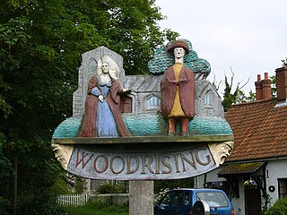
Woodrising is a village and former civil parish, now in the parish of Cranworth, in the Breckland district, in the county of Norfolk, England. The village of Woodrising is south of Dereham. In 1931 the parish had a population of 103.

Wilby is a village and former civil parish, 17 miles (27 km) south-west of Norwich, now in the parish of Quidenham, in the Breckland district, in the county of Norfolk, England. In 1931 the parish had a population of 94. Wilby has a church called All Saints. Wilby Hall, a country house is north of the village.
Southwood is a hamlet and former civil parish, 10 miles (16 km) east of Norwich, now in the parish of Cantley, Limpenhoe and Southwood, in the Broadland district, in the county of Norfolk, England. In 1931 the parish had a population of 40. It has a church called St Edmund which is in ruins. Southwood Hall is a post medieval great house and serves as a wedding venue.
Thrigby is a village and former civil parish 14 miles (23 km) east of Norwich, now in the parish of Mautby, in the Great Yarmouth district, in the county of Norfolk, England. In 1931 the parish had a population of 47.

West Tofts is a deserted medieval village in the civil parish of Lynford, within the Breckland district, in the county of Norfolk, England. It is within the Stanford Training Area, an army training area. In 1931 the parish had a population of 332. On 1 April 1935 the parish was abolished and merged with Lynford.

