
Morondava is a city located in Menabe Region, of which it is the capital, in Madagascar. It is located in the delta of the Morondava River at 20°17′5″S44°19′3″E. Its population as of the 2018 census, was 53,510.

Farafangana is a city on the south-east coast of Madagascar and capital of the Atsimo-Atsinanana region.
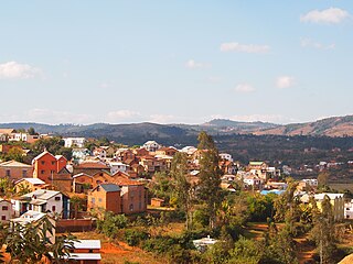
Ambositra is a city in central Madagascar.

Atsimo-Atsinanana is a region in Madagascar. Its capital is Farafangana. The region used to be part of the Fianarantsoa Province.

Ankazobe is a municipality in Analamanga Region, in the Central Highlands of Madagascar. It is the administrative capital of Ankazobe District and is situated at 75 km north of the capital Antananarivo.

Moramanga is a city in Madagascar. It is located in the region Alaotra-Mangoro and the Moramanga District. It has a population of 57084 inhabitants (2018).

Diana is a region in Madagascar at the northern part of the island. It borders the regions of Sava to the southeast and Sofia to the southwest. It covers an area of 19,266 km2, and had a population of 889,736 in 2018. The regional capital is Antsiranana.

The Montagne des Français Reserve is a protected area consisting principally of dry deciduous forest in northern Madagascar. It is part of the larger Ramena protected area complex which also includes Orangea Reserve and the Ambodivahibe Marine Reserve. These three protected areas are currently being created and will be designated in 2008.

Ramena is a rural municipality and a beach village in Madagascar. It belongs to the district of Antsiranana II, which is a part of Diana Region. The population of the municipality was 11521 in 2020. Only primary schooling is available.

Bealanana is a district in northern Madagascar. It is a part of Sofia Region and borders the districts of Ambanja in north, Ambilobe in northeast, Andapa in east, Befandriana-Nord in south, Antsohihy in southwest and Analalava in west. The area is 6,543 km2 (2,526 sq mi) and the population was estimated to be 201,836 in 2020.
Moramanga District is a district in the Alaotra-Mangoro region in Madagascar. Its capital is Moramanga.
Morondava District is a district in the Menabe region in eastern Madagascar. Its capital is Morondava. The district has an area of 5,691 km2 (2,197 sq mi), and the estimated population in 2020 was 157,596.

Route nationale 2 (RN2) is a primary highway in Madagascar. The route runs from the capital city of Antananarivo to Toamasina, a city on the eastern coast of the Madagascar.

796 Naval Air Squadron was a Naval Air Squadron of the Royal Navy's Fleet Air Arm which last disbanded at RNAS Culdrose in October 1958. 796 Naval Air Squadron formed as the Eastern Fleet Torpedo Bomber Reconnaissance Pool, at RN Air Section Port Reitz, in Mombasa, in July 1942, it provided a detachment embarked in HMS Illustrious in August to support the invasion of Madagascar. This Flight also disembarked to Majunga in September to join 207 Group of the Royal Air Force and later rejoined the squadron at RNAS Tanga, in November and added operational training unit to its roles until disbanding in April 1944. It reformed in November 1947 at HMS Vulture, RNAS St Merryn, as the Aircrewman Training School, for conversion of T.A.G.'s to aircrewman standard. Its task changed to Observer School Part II in January 1950. The squadron moved to HMS Seahawk, RNAS Culdrose, in November 1953 and in 1957 took on the task of the disbanded 765 Naval Air Squadron.

Mahitsy is rural municipality in Analamanga Region, in the Central Highlands of Madagascar. In the 2001 census, it had a population of 26,056.

Antsiranana II is a district of Diana in Madagascar.

Vohidiala is a rural municipality in Madagascar. It belongs to the district of Ambatondrazaka, which is a part of Alaotra-Mangoro Region.
Route nationale 1 is a primary highway in Madagascar of 234 km, running from Analavory, Miarinarivo to Tsiroanomandidy. It crosses the region of Bongolava and Analamanga

The Bemarivo river in Sofia Region, is located in northern Madagascar. It drains to the northern coast, into the Anjobony shortly before the Sofia River, near Boriziny.
