
Tambohorano is a rural municipality on the west coast of Madagascar approximately 290 kilometres north-west of the capital Antananarivo. It belongs to the district of Maintirano, which is a part of Melaky Region. The population of the commune was estimated to be approximately 8,000 in 2001.

Maintirano is a coastal city, urban municipality, and Catholic bishopric in western Madagascar approximately 325 kilometres west of the capital Antananarivo. It belongs to the district of Maintirano, which is a part of Melaky Region – and is capital of both.

Antsalova is a town and commune in western Madagascar. It belongs to the district of Antsalova, which is a part of Melaky Region. The population of the commune was estimated to be approximately 58,280 in 2018.

Ankazobe is a municipality in Analamanga Region, in the Central Highlands of Madagascar. It is the administrative capital of Ankazobe District and is situated at 75 km north of the capital Antananarivo.
Melaky is a region in northwestern Madagascar. It borders Boeny Region in northeast, Betsiboka in east, Bongolava in southeast and Menabe in south. The capital of the region is Maintirano. The population was estimated to be 309,805 in 2018 within the area of 38,852 km2 (15,001 sq mi). Melaky has the smallest population and the lowest population density of all Malagasy regions.
Betanatanana is a rural municipality in western Madagascar. It belongs to the district of Maintirano, which is a part of Melaky Region. The population of the commune was estimated to be approximately 7,000 in 2001 commune census.
Mafaijijo is a rural municipality in western Madagascar. It belongs to the district of Maintirano, which is a part of Melaky Region. The population of the commune was estimated to be approximately 5,000 in 2001 commune census.
Trangahy is a rural municipality in western Madagascar. It belongs to the district of Antsalova, which is a part of Melaky Region. The population of the commune was estimated to be approximately 8,000 in 2001 commune census.
Masoarivo is a rural municipality in western Madagascar. It belongs to the district of Antsalova, which is a part of the region of Melaky. The population of the commune was estimated to be approximately 8,000 in 2001 commune census.

Antsalova is a district in western Madagascar. It is a part of Melaky Region and borders the districts of Maintirano in north, Morafenobe in northeast, Miandrivazo in east and Belon'i Tsiribihina in south. The area is 7,195 km2 (2,778 sq mi) and the population was estimated to be 30,062 in 2001.
Besalampy is a district in western Madagascar. It is a part of Melaky Region and borders the districts of Soalala in northeast, Kandreho in east, Ambatomainty in southeast, Morafenobe in south and Maintirano in southwest. The area is 11,753 km2 (4,538 sq mi) and the population was estimated to be 62,347 in 2020.
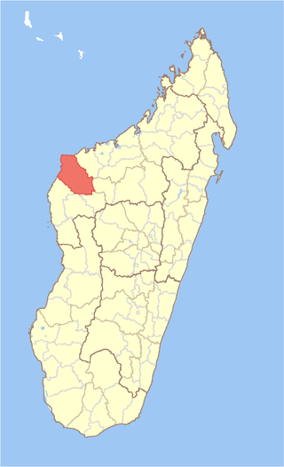
Maintirano is a district in western Madagascar. It is a part of Melaky Region and borders the districts of Besalampy in north, Morafenobe in east and Antsalova in south. The area is 10,031 km2 (3,873 sq mi) and the population was estimated to be 122,505 in 2020.

Morafenobe is a district in western Madagascar. It is a part of Melaky Region and borders the districts of Besalampy in north, Ambatomainty in east, Miandrivazo in south, Antsalova in southwest and Maintirano in west. The area is 7,414 km2 (2,863 sq mi) and the population was estimated to be 36,470 in 2020.

Moramanga District is a district in the Alaotra-Mangoro region in Madagascar. Its capital is Moramanga.
Route nationale 1 is a primary highway in Madagascar of 234 km, running from Analavory, Miarinarivo to Tsiroanomandidy. It crosses the region of Bongolava and Analamanga
Route nationale 1a is a secondary highway in Madagascar, running from Maintirano to Tsiroanomandidy. It crosses the region of Bongolava and Melaky
Andrea, Melaky is a rural municipality in western Madagascar. It belongs to the district of Maintirano, which is a part of Melaky Region. The population of the municipality was 6526 inhabitants in 2019.

Route nationale 19 (RN19) is a secondary, unpaved highway in Madagascar. The route runs from the city of Mahajanga, a city on the north-east coast of the Madagascar to Maintirano. It covers a distance of 523 km and is hardly practicable.