
Biella is a city and comune in the northern Italian region of Piedmont, the capital of the province of the same name, with a population of 44,324 as of 31 December 2017. It is located about 80 kilometres northeast of Turin and about 80 kilometres west-northwest of Milan.

Arborio is a comune (municipality) in the Province of Vercelli in the Italian region Piedmont, located about 70 kilometres (43 mi) northeast of Turin and about 20 kilometres (12 mi) north of Vercelli.
Balocco is a comune (municipality) in the Province of Vercelli in the Italian region Piedmont, located about 60 kilometres (37 mi) northeast of Turin and about 20 kilometres (12 mi) northwest of Vercelli. As of 31 December 2004, it had a population of 273 and an area of 16.7 square kilometres (6.4 sq mi). It is the home of the Circuito di Balocco road-testing track.
San Giacomo Vercellese is a comune (municipality) in the Province of Vercelli in the Italian region Piedmont, located about 70 kilometres (43 mi) northeast of Turin and about 20 kilometres (12 mi) northwest of Vercelli.
Crova is a comune (municipality) in the Province of Vercelli in the Italian region Piedmont, located about 50 kilometres (31 mi) northeast of Turin and about 15 kilometres (9 mi) west of Vercelli. As of 31 December 2004, it had a population of 431 and an area of 14.2 square kilometres (5.5 sq mi).
Gattinara is a comune (municipality) in the Province of Vercelli in the Italian region of Piedmont, located about 80 kilometres (50 mi) northeast of Turin and about 35 kilometres (22 mi) north of Vercelli. As of December 31, 2004, it had a population of 8,506 and an area of 33.5 square kilometres (12.9 sq mi).

Ghislarengo is a comune (municipality) in the Province of Vercelli in the Italian region Piedmont, located about 70 kilometres (43 mi) northeast of Turin and about 20 kilometres (12 mi) north of Vercelli.
Greggio is a comune (municipality) in the Province of Vercelli in the Italian region Piedmont, located about 70 kilometres (43 mi) northeast of Turin and about 15 kilometres (9 mi) north of Vercelli.
Lenta is a comune (municipality) in the Province of Vercelli in the Italian region Piedmont, located about 80 kilometres (50 mi) northeast of Turin and about 25 kilometres (16 mi) north of Vercelli.
Roasio is a comune (municipality) in the Province of Vercelli in the Italian region Piedmont, located about 80 kilometres (50 mi) northeast of Turin and about 35 kilometres (22 mi) northwest of Vercelli. As of 31 December 2004, it had a population of 2,517 and an area of 28.1 square kilometres (10.8 sq mi).

San Germano Vercellese is a comune (municipality) in the Province of Vercelli in the Italian region Piedmont, located about 50 kilometres (31 mi) northeast of Turin and about 14 kilometres (9 mi) northwest of Vercelli.

Tronzano Vercellese is a comune (municipality) in the Province of Vercelli in the Italian region Piedmont, located about 50 kilometres (31 mi) northeast of Turin and about 20 kilometres (12 mi) west of Vercelli.
Mandello Vitta is a comune (municipality) in the Province of Novara in the Italian region Piedmont, located about 80 kilometres (50 mi) northeast of Turin and about 13 kilometres (8 mi) northwest of Novara.
Sillavengo is a comune (municipality) in the Province of Novara in the Italian region of Piedmont, located about 80 kilometres (50 mi) northeast of Turin and about 15 kilometres (9 mi) northwest of Novara.
Brusnengo is a comune (municipality) in the Province of Biella in the Italian region Piedmont, located about 70 kilometres (43 mi) northeast of Turin and about 12 kilometres (7 mi) northeast of Biella. As of 31 December 2004, it had a population of 2,127 and an area of 10.4 square kilometres (4.0 sq mi).
Castelletto Cervo is a comune (municipality) in the Province of Biella in the Italian region Piedmont, located about 60 kilometres (37 mi) northeast of Turin and about 20 kilometres (12 mi) southeast of Biella. As of 31 December 2004, it had a population of 862 and an area of 15.0 square kilometres (5.8 sq mi).
Masserano is a comune (municipality) in the Province of Biella in the Italian region Piedmont, located about 70 kilometres (43 mi) northeast of Turin and about 12 kilometres (7 mi) northeast of Biella. As of 31 December 2004, it had a population of 2,315 and an area of 27.1 square kilometres (10.5 sq mi).
Santhià railway station is the main station serving the comune of Santhià, in the Piedmont region, northwestern Italy. It is the junction of the Turin–Milan, Santhià–Biella and Santhià–Arona railways.
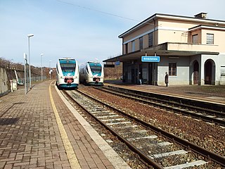
Rovasenda railway station is one of two train stations, serving the comune of Rovasenda, in the Piedmont region, northwestern Italy. It is the junction of the Biella–Novara. It also plays a role interchange with station Rovasenda Alta of line Santhià–Arona.

Rovasenda railway station is one of two train stations, serving the comune of Rovasenda, in the Piedmont region, northwestern Italy. The name "Alta" (High) has been assigned to distinguish by the station low. It is the junction of the Santhià–Arona. It also plays a role interchange with station Rovasenda (low) of line Biella–Novara.


