
Hawick is a town in the Scottish Borders council area and historic county of Roxburghshire in the east Southern Uplands of Scotland. It is 10 miles (16.1 km) south-west of Jedburgh and 8.9 miles (14.3 km) south-south-east of Selkirk. It is one of the furthest towns from the sea in Scotland, in the heart of Teviotdale, and is the biggest town in Roxburghshire. The town is at the confluence of the Slitrig Water with the River Teviot.
West Lothian is one of the 32 council areas of Scotland, and was one of its historic counties. The county was called Linlithgowshire until 1925. The historic county was bounded geographically by the Avon to the west and the Almond to the east. The modern council area occupies a larger area than the historic county. It was reshaped following local government reforms in 1975: some areas in the west were transferred to Falkirk; some areas in the east were transferred to Edinburgh; and some areas that had formerly been part of Midlothian were added to West Lothian.

The River Forth is a major river in central Scotland, 47 km (29 mi) long, which drains into the North Sea on the east coast of the country. Its drainage basin covers much of Stirlingshire in Scotland's Central Belt. The Gaelic name for the upper reach of the river, above Stirling, is Abhainn Dubh, meaning "black river". The name for the river below the tidal reach is Uisge For.

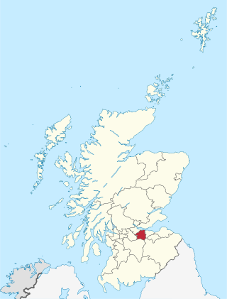
Dumfriesshire or the County of Dumfries or Shire of Dumfries is a historic county and registration county in southern Scotland. The Dumfries lieutenancy area covers a similar area to the historic county.

The Glenfinnan Viaduct is a railway viaduct on the West Highland Line in Glenfinnan, Inverness-shire, Scotland, built from 1897 to 1901. Located at the top of Loch Shiel in the West Scottish Highlands, the viaduct overlooks the Glenfinnan Monument and the waters of Loch Shiel.

Loanhead is a town in Midlothian, Scotland, in a commuter belt to the south of Edinburgh, and close to Roslin, Bonnyrigg and Dalkeith. The town was built on coal and oil shale mining, and the paper industries.

Falls of Cruachan railway station is a railway station located at the foot of Ben Cruachan in Scotland. This station is on the Oban branch of the West Highland Line, originally part of the Callander and Oban Railway. It is sited between Taynuilt and Loch Awe, sited 52 miles 69 chains (85.1 km) from Callander via Glen Ogle. ScotRail manage the station and operate all services.
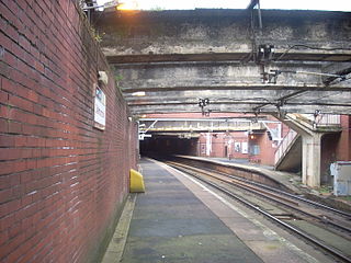
Dalmarnock railway station, serving the Dalmarnock area of Glasgow, Scotland, lies on the Argyle Line, two and a quarter miles (3.6 km) southeast of Glasgow Central. The northern ends of the side platforms are within a tunnel. Revamped for the 2014 Commonwealth Games, the station is a 15-minute walk from the Commonwealth Arena and Sir Chris Hoy Velodrome, and Celtic football club's Celtic Park stadium at Parkhead. Due to this, The station is busy on matchdays and a queueing system takes place on Swanson Street
Stoneyburn is a village in West Lothian, Scotland. The village was the site of a large coalmine, since discontinued. Nearby towns include Bathgate, Whitburn, Addiewell and Blackburn. Around two thousand people inhabit the village (2022), which is around 1.5 miles in length, clustered around the B7015 to Fauldhouse and Livingston.

The Edinburgh and Dalkeith Railway was an early railway built to convey coal from pits in the vicinity of Dalkeith into the capital. It was a horse-operated line, with a terminus at St Leonards on the south side of Arthur's Seat.
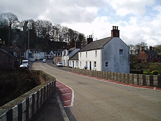
Carronbridge is a village in the parish of Morton in Dumfries and Galloway, Scotland. The village is at the junction of the A76 and A702 roads approximately 1 mile (2 km) north of Thornhill. The hamlet of Enterkinfoot lies slightly to the north. To the west of the village the Carron Water flows into the River Nith. Carronbridge Sawmill is in the village and is a Category B listed building built in the 1850s for the Duke of Buccleuch's Drumlanrig estate.
Canonbie is a small village in Dumfriesshire within the local authority area of Dumfries and Galloway in Scotland, 6 miles south of Langholm and 2 miles north of the Anglo-Scottish border. It is on the A7 road from Carlisle to Edinburgh, and the River Esk flows through it. There are frequent references in older documents to it as Canobie.
The village or hamlet of Gatehead is in East Ayrshire, Kilmaurs, Scotland. It is one and a quarter miles from Crosshouse and one and a half miles from Kilmarnock. In the 18th and 19th centuries the locality was a busy coal mining district. The settlement runs down to the River Irvine where a ford and later a bridge was located.

Middlebie is a hamlet and parish in the historic county of Dumfriesshire in Dumfries and Galloway, south-west Scotland. It is approximately 2 miles (3.2 km) east of Ecclefechan, and 6 miles (9.7 km) north-east of Annan, on the banks of the Middlebie Burn.

Blairhall is a village in West Fife, Scotland. It is situated 1.1 miles (1.77 km) west of Comrie, and 6.7 miles (10.783 km) west of Dunfermline. The village was originally a small hamlet but was expanded in 1911 to house the miners from a nearby colliery. Today Blairhall has a primary school and a community leisure centre. The village has a population of around 1000 people.
The North British, Arbroath and Montrose Railway was a company established by Act of Parliament in 1871 to construct and operate a railway line from north of Arbroath via Montrose to Kinnaber Junction, 38 miles (61 km) south of Aberdeen. The company was originally a subsidiary of the North British Railway but was absorbed into its parent in 1880.

The Glenmuir Water is a river in Ayrshire, Scotland.The river rises high in the hills south of Muirkirk. On reaching Lugar the Glenmuir is joined by the Bellow Water and is renamed the Lugar Water. Ayrshire Rivers TrustArchived 7 March 2021 at the Wayback Machine monitor water quality for the river and visit annually.

Riddings Junction Viaduct is a disused cross-border railway bridge over Liddel Water between Kirkandrews, in Cumbria, north-western England, and Canonbie in Dumfries and Galloway, south-western Scotland. It is a listed building in both countries; the Scottish section is category A listed, and the English section is Grade II*.
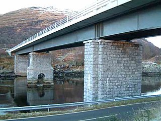
Creagan Bridge is a bridge that crosses Loch Creran at Creagan in Scotland. It is a road bridge that uses the supporting columns of a former railway viaduct.

The Cullen Viaduct is a former single-track railway viaduct at the Moray Firth in Cullen, Moray, Scotland. Containing eight arches, it formerly carried the Great North of Scotland Railway line between Portsoy in Aberdeenshire and Elgin in Moray. Crossing the Burn of Cullen and the A98, it was built as a result of a refusal by Seafield Estate, to the south, to have the line encroach on its land.
