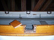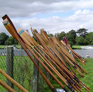
An oar is an implement used for water-borne propulsion. Oars have a flat blade at one end. Rowers grasp the oar at the other end.

Ruokolahti is a municipality of Finland, situated in south-eastern Finland, in the region of South Karelia. Neighbouring municipalities are Imatra, Lappeenranta, Taipalsaari, Puumala, Sulkava, Punkaharju, Parikkala and Rautjärvi. Ruokolahti covers an area of 1,219.85 square kilometres (470.99 sq mi) of which 23% is water.

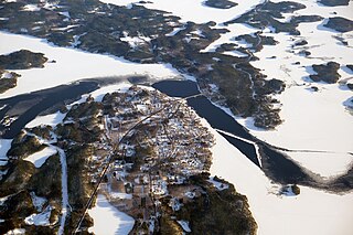
Hailuoto is a Finnish island in the northern Baltic Sea and a municipality in Northern Ostrobothnia region. The population of Hailuoto is 948, making it the smallest municipality in Northern Ostrobothnia and the former Oulu Province in terms of population. The municipality covers an area of 205.65 km2 (79.40 sq mi) of which 1.70 km2 (0.66 sq mi) is inland water. The population density is 4.61/km2 (11.9/sq mi). Of all the Finnish sea islands, Hailuoto is the third largest after Fasta Åland and Kimitoön.
Eno is a former municipality of Finland, now part of Joensuu. It is located in the province of Eastern Finland and is part of the North Karelia region. The municipality had a population of 6,764 and covered an area of 1,088.25 km² of which 149.30 km² was water. The population density was 6.2 inhabitants per km².

Kärsämäki is a municipality of Finland. It is located in the province of Oulu and is part of the Northern Ostrobothnia region. The municipality has a population of 2,441 and covers an area of 700.91 square kilometres (270.62 sq mi) of which 6.06 km2 (2.34 sq mi) is water. The population density is 3.5 inhabitants per square kilometre (9.1/sq mi). Kärsämäki is a significant road junction where Highway 4 (Helsinki–Oulu–Utsjoki) and Highway 28 (Kokkola–Kajaani) intersect and where Highway 58 leading to Kangasala begins. The distance to the regional capital Oulu is 123 kilometres (76 mi).

Nivala is a town and municipality of Finland. It is located in the Northern Ostrobothnia region. The town has a population of 10,450 (31 December 2023) and covers an area of 536.88 square kilometres (207.29 sq mi) of which 8.92 km2 (3.44 sq mi) is water. The population density is 19.82 inhabitants per square kilometre (51.3/sq mi). The municipality is unilingually Finnish.

Perho is a municipality of Finland. It is located in the province of Western Finland and is part of the Central Ostrobothnia region. The distance between Perho and the regional center Kokkola is about 100 kilometres (62 mi). The municipality has a population of 2,578 and covers an area of 775.19 square kilometres (299.30 sq mi) of which 27.25 km2 (10.52 sq mi) is water. The population density is 3.45 inhabitants per square kilometre (8.9/sq mi).
Pertunmaa is a municipality of Finland located in the Southern Savonia region. The municipality has a population of 1,575 and covers an area of 454.20 square kilometres (175.37 sq mi) of which 79.7 km2 (30.8 sq mi) is water. The population density is 4.21 inhabitants per square kilometre (10.9/sq mi).
Pudasjärvi is a town and a municipality of Finland. It is located in the province of Oulu and is part of the Northern Ostrobothnia region, 87 kilometres (54 mi) northeast of the city of Oulu and 130 kilometres (81 mi) southwest of the town of Kuusamo. The town has a population of 7,483 and covers an area of 5,867.23 square kilometres (2,265.35 sq mi) of which 228.67 km2 (88.29 sq mi) is water. The population density is 1.33 inhabitants per square kilometre (3.4/sq mi). In terms of area in square kilometres, Pudasjärvi is the second largest township in Finland and one of the largest in the world. It's also one of the most sparsely inhabited.
Puumala is a municipality of Finland. It is located in the Southern Savonia region. The municipality has a population of 2,110 and covers an area of 1,237.75 square kilometres (477.90 sq mi) of which 443.17 km2 (171.11 sq mi) is water. The population density is 2.66 inhabitants per square kilometre (6.9/sq mi).
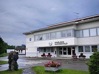
Pyhäjoki is a municipality of Finland. It is located in the defunct province of Oulu, which was split in two regions; Pyhäjoki is part of the Northern Ostrobothnia region. It is located 102 kilometres (63 mi) southwest of the city of Oulu.
Savitaipale is a municipality of Finland. It is located in the South Karelia region. The municipality has a population of 3,215 and covers an area of 690.56 square kilometres (266.63 sq mi) of which 150.81 km2 (58.23 sq mi) is water. The population density is 5.96 inhabitants per square kilometre (15.4/sq mi).
Sonkajärvi is a municipality of Finland. It is located in Northern Savonia region, 105 kilometres (65 mi) north of Kuopio. The municipality has a population of 3,635 and covers an area of 1,576.78 square kilometres (608.80 sq mi) of which 110.86 km2 (42.80 sq mi) is water. The population density is 2.48 inhabitants per square kilometre (6.4/sq mi). The municipality is unilingually Finnish.

Taivassalo is a municipality of Finland, about 50 kilometres (31 mi) from the city of Turku. It is located in the Southwest Finland region. The municipality has a population of 1,701 and covers an area of 217.68 square kilometres (84.05 sq mi) of which 77.23 km2 (29.82 sq mi) is water. The population density is 12.12 inhabitants per square kilometre (31.4/sq mi).

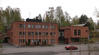
Toivakka is a municipality of Finland. It is located in the Central Finland region, near Jyväskylä. The municipality has a population of 2,369 (31 December 2023) and covers an area of 413.94 square kilometres (159.82 sq mi) of which 52.44 km2 (20.25 sq mi) is water. The population density is 6.55 inhabitants per square kilometre (17.0/sq mi). The municipality is unilingually Finnish.

Rowing is the act of propelling a human-powered watercraft using the sweeping motions of oars to displace water and generate reactional propulsion. Rowing is functionally similar to paddling, but rowing requires oars to be mechanically attached to the boat, and the rower drives the oar like a lever, exerting force in the same direction as the boat's travel; while paddles are completely hand-held and have no attachment to the boat, and are driven like a cantilever, exerting force opposite to the intended direction of the boat.
In competitive rowing, the following specialized terms are important in the corresponding aspects of the sport:

The coat of arms of Jakobstad, a town in Finland, was drawn in its current form by Gustaf von Numers. It portrays a red-crowned, sword-holding a blue lion with a split tail. The lion is standing in a red tower in blue water. The background is gold-colored. The shield is crowned by a baronial coronet.

The coat of arms of Lappajärvi in Finland was drawn by Ahti Hammar and adopted in 1957. The arms refer to Lake Lappajärvi, which gives its name to the municipality and is a meteor crater.

Teisko is a village and former municipality in Pirkanmaa region, Finland. It was consolidated in 1972 with Tampere, and at the same time Tampere got new districts: Kämmenniemi, Polso, Terälahti and Velaatta. Teisko's neighboring municipalities were Kangasala, Kuru, Orivesi, Ruovesi, Aitolahti and Ylöjärvi. Initially, the municipality comprised areas on both sides of Lake Näsijärvi, but in 1954, the areas west of Lake Näsijärvi were connected to Ylöjärvi and Kuru.