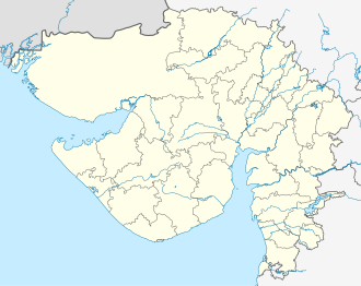
Royal is a village near Talaja in Bhavnagar district in the Indian state of Gujarat. As of [update] the 2011 Census of India, it had a population of 2,955 across 540 households. [1]
Royal is a village near Talaja in Bhavnagar district in the Indian state of Gujarat. As of [update] the 2011 Census of India, it had a population of 2,955 across 540 households. [1]

India is the second most populated country in the world with a sixth of the world's population. According to the 2019 revision of the World Population Prospects the population stood at 1,352,642,280. In January 2022, India's population crossed 1.41 billion.

The Kingdom of Travancore (/ˈtrævənkɔːr/), also known as the Kingdom of Thiruvithamkoor, was an Indian kingdom from c. 1729 until 1949. It was ruled by the Travancore Royal Family from Padmanabhapuram, and later Thiruvananthapuram. At its zenith, the kingdom covered most of the south of modern-day Kerala, and the southernmost part of modern-day Tamil Nadu with the Thachudaya Kaimal's enclave of Irinjalakuda Koodalmanikyam temple in the neighbouring Kingdom of Cochin. However Tangasseri area of Kollam city and Anchuthengu near Attingal in Thiruvananthapuram district, were British colonies and were part of the Malabar District until 30 June 1927, and Tirunelveli district from 1 July 1927 onwards. Travancore merged with the erstwhile princely state of Cochin to form Travancore-Cochin in 1950. The five Tamil-majority Taluks of Vilavancode, Kalkulam, Thovalai, Agastheeswaram, and Sengottai were transferred from Travancore-Cochin to Madras State in 1956. The Malayalam-speaking regions of Travancore-Cochin merged with the Malabar District and the Kasaragod taluk of the South Canara district in Madras State to form the modern Malayalam-state of Kerala on 1 November 1956, according to the States Reorganisation Act, 1956 passed by the Government of India.

Seraikela-Kharsawan district or Saraikella and Kharaswan district is one of the twenty-four districts of Jharkhand state in eastern India. Seraikela town is the district headquarters of Saraikela Kharsawan district. The district is well known for Seraikela Chhau, one of the three distinctive styles of the chhau dance. This district was carved out from West Singhbhum district in 2001. The district was formed from the Odia princely states of Seraikela and Kharaswan, after the independence of India.

Tinsukia is an industrial town. It is situated 480 kilometres (298 mi) north-east of Guwahati and 84 kilometres (52 mi) away from the border with Arunachal Pradesh.
Dang is a district in the southeastern part of the state of Gujarat in western India. The administrative headquarters of the district are located in Ahwa. Dang has an area of 1,764 km² and a population of 228,291. As of 2011, it is the least populous district of Gujarat. As per the Planning Commission, Dang is one of the most economically distressed district out of 640 districts in India. 94% of the population belongs to one of the scheduled tribes. The five Kings of Dangs are the only hereditary royals in India whose titles are currently recognized by the government owing to an agreement made during the British Raj in 1842.

Mumbai City District is a district of Maharashtra in Konkan Division. As a city district, it has no headquarters or subdivisions. It, along with the Mumbai Suburban District, makes up the metropolis of Mumbai. The city area is called the "island city" or South Mumbai or Old Mumbai. It extends from Colaba in the south to Mahim and Sion in the north. The city has an area of 157 km2 (61 sq mi) and a population of 3,085,411.

Raisen District is a district of Madhya Pradesh state of India. The town of Raisen is the district headquarters. The district is part of Bhopal Division. Sanchi University of Buddhist-Indic Studies is the first international university located at Sanchi Town.

Vellore district is one of the 38 districts in the Tamil Nadu state of India. It is one of the eleven districts that form the north region of Tamil Nadu. Vellore city is the headquarters of this district. As of 2011, the district had a population of 1,614,242 with a sex ratio of 1,007 females for every 1,000 males. In 2017 Vellore district ranked eleventh in list of districts in Tamil Nadu by Human Development Index.

Bharuch in India, is a district in the southern part of the Gujarat peninsula on the west coast of state of Gujarat with a size and population comparable to that of Greater Boston. The Narmada River outlets into the Gulf of Khambat through its lands and that shipping artery gave inland access to the kingdoms and empires located in the central and northern parts of the sub-continent of India.

Kottayam-Malabar is a census town near Kuthuparamba in Kannur district of Kerala state in India. It is different from the city of Kottayam in Kottayam district of the same state.

Shopian or Shupiyan, known as Shupyan in Kashmiri, is an administrative division of the Shopian district, located in southern part of Kashmir Valley, of Jammu and Kashmir, India. Shopian is called the ''Apple town of Kashmir'' as majority of the population engages in apple growing practices which also provides employment to more than 60% of the population. Apple town of kashmir

Tiruvottriyur is a neighbourhood in North Chennai, administered by the Greater Chennai Corporation. It is part of the Tondiarpet division, located to the north of Chennai city. It is one of the 15 administrative zones in Greater Chennai Corporation. The zone is named to be Zone 1 (Tiruvottriyur).
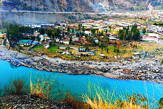
Ramban is a town in Ramban district of Jammu and Kashmir, India, which is the district headquarters of Ramban district. It lies on the banks of the Chenab river in Chenab Valley on the National Highway-1A at about 150 km from Jammu and about 150 km from Srinagar, making it almost the central point on the Jammu-Srinagar National Highway.
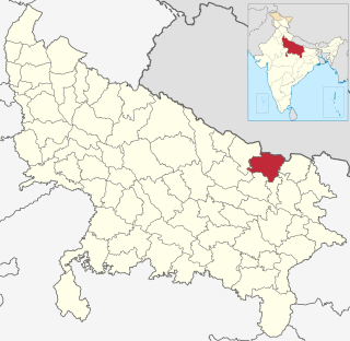
Siddharthnagar district is one of the 75 districts of the Indian state of Uttar Pradesh also known as the birthplace of Gautama Buddha.Siddharthnagar is the district headquarters. Siddharthnagar district is a part of Basti division.

The 2011 Census of India or the 15th Indian Census was conducted in two phases, house listing and population enumeration. The House listing phase began on 1 April 2010 and involved the collection of information about all buildings. Information for National Population Register (NPR) was also collected in the first phase, which will be used to issue a 12-digit unique identification number to all registered Indian residents by Unique Identification Authority of India. The second population enumeration phase was conducted between 9 and 28 February 2011. Census has been conducted in India since 1872 and 2011 marks the first time biometric information was collected. According to the provisional reports released on 31 March 2011, the Indian population increased to 1.21 billion with a decadal growth of 17.70%. Adult literacy rate increased to 74.04% with a decadal growth of 9.21%. The motto of the census was 'Our Census, Our future'.

Mangalgarh is a panchayat village in the Berasia tehsil of Bhopal district, Madhya Pradesh, India.

Registrar General and Census Commissioner of India, founded in 1961 by Government of India Ministry of Home Affairs, for arranging, conducting and analysing the results of the demographic surveys of India including Census of India and Linguistic Survey of India. The position of Registrar is usually held by a civil servant holding the rank of Joint Secretary.

Jammu and Kashmir is a region administered by India as a union territory and consisting of the southern portion of the larger Kashmir region, which has been the subject of a dispute between India and Pakistan since 1947, and between India and China since 1962. The Line of Control separates Jammu and Kashmir from the Pakistani-administered territories of Azad Kashmir and Gilgit-Baltistan in the west and north. It lies to the north of the Indian states of Himachal Pradesh and Punjab and to the west of Ladakh, which is also subject to the dispute as a part of Kashmir, and administered by India as a union territory.
| | This article about a location in Bhavnagar district, Gujarat, India is a stub. You can help Wikipedia by expanding it. |