Kanayi is a village in Kannur district, Kerala, in South India. It is at a distance of 12 km from Payyannur. Vannathi Puzha and Meenkuzhi Dam are very important for its agriculture and fishing. It is the birthplace of the noted sculptor Kanayi Kunhiraman.

Ayer Tawar is a town in Manjung District, Perak, Malaysia. Its name came from Air Tawar, which literally means "fresh water" in the Malay language.
Adavad, also spelt Adawad or Adwad, is a village in the Chopda Tehsil of Jalgaon District, Maharashtra, India. It is situated at the southern base of the Satpura Hills, about 30 kilometres northwest of the district seat Jalgaon, and 13 kilometres east of the subdistrict seat Chopda. As of the year 2011, it has a total population of 24,357.
Nitte is a village in Karkala Taluk, Udupi District, Karnataka, India. It is located on the way from Padubidri to Karkala, about 26 kilometres southeast of the district capital Udupi, and 7 kilometres southwest of the taluka capital Karkala. In the year 2011, the village is home to 12,354 inhabitants.

Wandoor is a town in Nilambur Taluk, Malappuram District, Kerala, India. It is located on the southeast of Chaliyar River, about 24 kilometres northeast of the district seat Malappuram, and 8 km south of the taluk seat Nilambur. In the year 2011, the town has a population of 50,973.
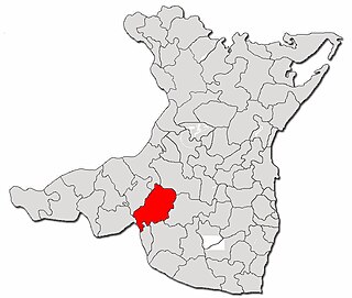
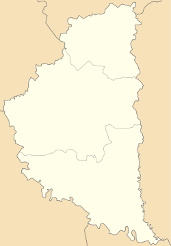
Deleni is a commune in Constanța County, Northern Dobruja, Romania. It is situated in the southern part of the county, 59 km (37 mi) west of Constanța.

Lorcha, or L'Orxa, is a municipality in the comarca of Comtat in the Valencian Community, Spain. As of the year 2021, it has a total population of 581.
Liaquatpur is a city and capital of Liaquatpur Tehsil in Rahim Yar Khan District, Punjab, Pakistan. It is located on the north of Liaquatpur Tehsil, about 90 kilometres to the northeast of Rahim Yar Khan. As of 2017, it has a total population of 51,888. Liaquat Pur is the Biggest Market of Jaggery (Gor) in South Asia.
Chinchali is a village in Raybag Taluk, Belagavi District, Karnataka, India. It is located near the state boundary with Maharashtra, approximately 84 kilometres north of the district seat Belgaum, and 10 kilometres northeast of the taluk seat Raibag. In the year 2011, the village has a population of 18,986.
Nazarezinho is a municipality in the state of Paraíba in the Northeast Region of Brazil. As of the year 2021, its total population is 7,271.
Cedral is a town and municipality in the Mexican state of San Luis Potosí in central Mexico. As of the year 2020, it has a total population of 19,840.
Mohare is a village in Bailhongal Taluk, Belagavi District of Karnataka, India. It is located near the state border with Maharashtra, about 26 kilometres east of the district seat Belgaum, and 16 kilometres northwest of the taluk seat Bailhongal. As of 2011, it has a total population of 2,365.

Pryazovskyi National Nature Park is the second largest national park of Ukraine, covering the estuaries, coastal plains seaside landforms around the Molochna River estuary the Utlyuksky estuary, on the northwest coast of the Sea of Azov. The area is one of high biodiversity, protecting both steppe and aquatic habitats, and the unique transition zones in between. The wetlands support very large populations of nesting and migratory waterfowl. The park is crosses several administrative districts, including Pryazovske Raion, Melitopol Raion, Berdiansk Raion, and Yakymivka Raion in Zaporizhzhia Oblast.

Ichnia National Nature Park is a national park of Ukraine that covers forest-steppe terrain in the Uday basin, about 120 km northeast of Kyiv. The park is administratively in Pryluky Raion in Chernihiv Oblast.
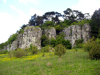
Medobory Nature Reserve is a protected nature reserve of Ukraine located in the Podolian Upland in the western part of the country. It protects a representative portion of the "Tovtry" region, known for rocky limestone ridges. The reserve is in Chortkiv and Ternopil Raions of Ternopil Oblast.

Pujut is a district of Central Lombok Regency, West Nusa Tenggara, Indonesia. Its administrative center is in the village of Sengkol. It borders Central Praya District to the north, East Praya District to the east, the Indian Ocean to the south, and the West Praya District to the west. In the year 2022, there were 120,538 inhabitants within the district.
Dhamdaha is a town and the administrative Block in Purnia District, Bihar, India. It is situated in the Eastern part of Bihar, about 26 kilometres southwest of Purnia. In the year 2011, the village has a total population of 37,987.

Tinta is the capital town of Tinta District, Canchis Province, Department of Cuzco, Peru. It is located at an altitude of 3,836 meters above the sea level. As of the year 2017, it had a total population of 2,910.

Mali Chornokintsi is a village in Kolydinay rural hromada, Chortkiv Raion, Ternopil Oblast, Ukraine. As of 2018, the village has a population of 411.
Dos Ríos is a locality in the municipality of Emiliano Zapata, Veracruz, Mexico. It is located on the southeastern part of the country, about 77 kilometers northwest of the city of Veracruz. As of the year 2020, it had a total population of 1,698.